40 acres in Apache County, Arizona
Survey has been completed and is Photo #2, so now is the time to place your deposit to reserve this 40 acre parcel. Only 6 miles to Sanders just off Hwy 191, this Northern Arizona property has unlimited possibilities with panoramic views and great access. BONUS: New road just cut in! **Up to 255 acres available.
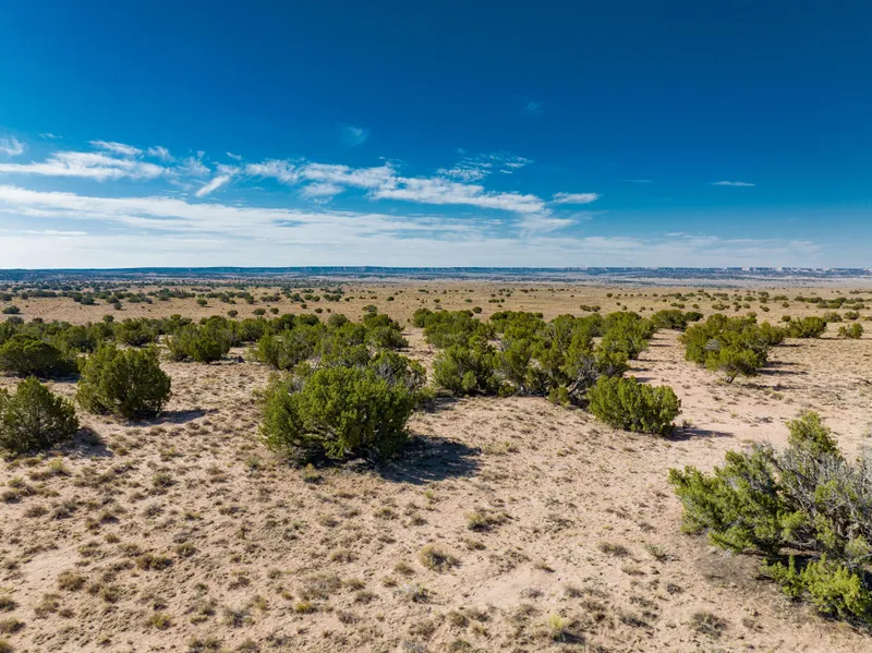
This rare property gives you gorgeous acreage with stunning mountain and canyon views along with level stretches of pasture and rolling hills of grass, sage and Juniper. Ideal for your dream ranch, whether it is horses, cows, goats, llamas or all of them. Plenty of room to build, have barns, corrals, garages, guest quarters, and so much more. The terrain is beautifully varied with rolling hills and trees, giving you your pick of ideal building sites. There is a small wash that spans across the property from the southeast to southwestern border that could make for great water source during monsoon season. As youll see in the photos and video, this land has a lot of character and plenty of privacy. The views are absolutely outstanding! With great access, you can easily get to Highway 191 (AZ 61) and I-40 (historic Route 66). Head out and spend your day fishing at Lyman Lake or exploring the natural wonder of the Petrified Forest. Witch Well Store is just south of you or head north to Sanders for a little small town charm and local eats. Surrounded by landscape views and vibrant Junipers, you have everything you need to live your off-grid dream!
This property has NO owners association nor covenants.
-No restrictions on dwelling size
-You can build anything for residential purposes such as Single Family, Mobile or Manufactured home
-Camping & RVs are okay as well (permits required for long-term stay, more than 30 days)
Visiting the Property: We are not real estate agents and we actually own the properties we have for sale. We run a self-service setup which means you are welcome to go view the property on your schedule and at your leisure. We only ask that you do so during daylight hours. Weve provided everything you need in the listing, including GPS coordinates of the four corners of the property and a Google Maps link so you can plug in directions to take you right to the property. Land id (formerly MapRight) is a great tool we provide to help you locate and walk the property. Its free to download and you dont need to register. When youre ready to visit the property, contact us and we will share the property map with you directly.
Access to the property is right off Highway 191. Coming from Sanders, head south for 6 miles until you reach a turnoff to a frontage road where youll turn Right and keep going south. Take that about .2 miles and take a Right at the first road on an unnamed easement road. From there you will drive another .2 miles and take a Left turn at the second dirt road. Go south for about .25 miles until you reach a T and take a Right, follow this newly cut in easement road that leads directly to the northeastern border of the property. See the map photos for details on directions.
I have included ACTUAL property photos as well as a video tour of the property. I have not visited this property yet but I have put everything I know about it in the details below.
WHATS CLOSE?
6 miles to Dollar General, Gas & Post Office in Sanders
18 miles to Witch Well Store
36 miles to Petrified Forest National Park
1 hour to Lyman Lake State Park
1.5 hours to Walmart Supercenter in Taylor/Snowflake
2 hours to Flagstaff
3 hours to Albuquerque
4 hours to Phoenix
PROPERTY DETAILS
Size (Acres): 40.00 +/-
General Location: US Highway 191/N7372, Sanders, AZ 86512
APN or Other ID: APN To Be Determined, Parcel 3 in Photo
Subdivision: N/A
Legal Description: Parcel 3, A Portion of land being located in the S 1/2 of Section 23, Township 20 North, Range 28 East, Apache County, Arizona
Approx. GPS:
35.118124, -109.337018
35.118125, -109.333732
35.113306, -109.333655
35.113296, -109.336913
Property Type: Rural Land
Land Use: Houses, tiny homes, THOWs, RVs, travel trailers, vanlife, camping, recreational uses, agricultural uses
Zoning: General Agricultural, For more information, contact Apache County 928-337-7526 or visit their website
POA: No
Terrain: Varied
General Elevation: Approx. 6,100
Power: Would be by generator, solar or wind.
Phone: Mobile/Satellite/Alternative
Water: Would need to drill well or use alternative system
Sewer: Would need septic or alternative system
Roads: Dirt, 4WD Recommended
Title Info: Free & Clear Title, Conveyed from LG Solutions LLC
Annual Property Taxes: Approx. $50
Doc Fee: Terms $499, Cash Responsibility of Buyer (To be closed through Pioneer Title)
From elevation to risk assessment
Search for detailed parcel information including; Elevation & Vegetation Maps, Ownership Information, Detailed Parcel Information, Crop History Map, Soil Survey Productivity Data, and more.
Research Parcel InformationDirections
Access to the property is right off Highway 191. Coming from Sanders, head south for 6 miles until you reach a turnoff to a frontage road where youll turn Right and keep going south. Take that about .2 miles and take a Right at the first road on an unnamed easement road. From there you will drive another .2 miles and take a Left turn at the second dirt road. Go south for about .25 miles until you reach a T and take a Right, follow this newly cut in easement road that leads directly to the northeastern border of the property. See the map photos for details on directions.
Visiting the Property: We are not real estate agents and we actually own the properties we have for sale. We run a self-service setup which means you are welcome to go view the property on your schedule and at your leisure. We only ask that you do so during daylight hours. Weve provided everything you need in the listing, including GPS coordinates of the four corners of the property and a Google Maps link so you can plug in directions to take you right to the property. Land id (formerly MapRight) is a great tool we provide to help you locate and walk the property. Its free to download and you dont need to register. When youre ready to visit the property, contact us and we will share the property map with you directly.
About Dave Ayres
My name is Dave Ayres. Since 2005, my wife (Christy) and I have been providing affordable housing and land. We are now investing in land at higher volumes to offer EXTREMELY affordable land investing opportunities to everyday people like ourselves. Circle7Land.com is all about making land ownership easy and affordable. We specialize in beautiful rural raw land and we have been expanding to serve the public through offering 1/4 acre to 160 acre properties at wholesale prices. Our dream is that everyone can enjoy land in a way that celebrates their unique life so they can build memories and create legacy. As a small family-owned property investment company, we pride ourselves on quick, professional and easy transactions guaranteeing seller satisfaction. So, whether youre looking to establish a wide-ranging portfolio of properties or simply acquire one or two as investments for future generations, we welcome you to contact us at Circle7Land.com 720-807-7778.
Land for Sale by Dave Ayres
Previously Sold by Dave Ayres
Apache County Properties By Type
- Undeveloped Land for Sale in Apache County, Arizona
- Ranches for Sale in Apache County, Arizona
- Farms for Sale in Apache County, Arizona
- Residential Property for Sale in Apache County, Arizona
- Recreational Property for Sale in Apache County, Arizona
- Lakefront Property for Sale in Apache County, Arizona
- Hunting Land for Sale in Apache County, Arizona
- Horse Property for Sale in Apache County, Arizona
- Riverfront Property for Sale in Apache County, Arizona
- Timberland for Sale in Apache County, Arizona
- Beachfront Property for Sale in Apache County, Arizona
- Commercial Property for Sale in Apache County, Arizona
Properties for Sale Nearby Counties
- Catron County, Arizona Land for Sale
- Cibola County, Arizona Land for Sale
- Graham County, Arizona Land for Sale
- Greenlee County, Arizona Land for Sale
- McKinley County, Arizona Land for Sale
- Montezuma County, Arizona Land for Sale
- Navajo County, Arizona Land for Sale
- San Juan County, Arizona Land for Sale
- San Juan County, Arizona Land for Sale
Apache County Properties By City
- Alpine, Arizona Land for Sale
- Chambers, Arizona Land for Sale
- Chinle, Arizona Land for Sale
- Concho, Arizona Land for Sale
- Dennehotso, Arizona Land for Sale
- Eagar, Arizona Land for Sale
- Fort Defiance, Arizona Land for Sale
- Ganado, Arizona Land for Sale
- Greer, Arizona Land for Sale
- Houck, Arizona Land for Sale
- Lukachukai, Arizona Land for Sale
- Lupton, Arizona Land for Sale
- More
- Many Farms, Arizona Land for Sale
- Mcnary, Arizona Land for Sale
- Nazlini, Arizona Land for Sale
- Nutrioso, Arizona Land for Sale
- Rock Point, Arizona Land for Sale
- Round Rock, Arizona Land for Sale
- Saint Johns, Arizona Land for Sale
- Saint Michaels, Arizona Land for Sale
- Sanders, Arizona Land for Sale
- Springerville, Arizona Land for Sale
- Teec Nos Pos, Arizona Land for Sale
- Vernon, Arizona Land for Sale
- Window Rock, Arizona Land for Sale
- Concho Valley, Arizona Land for Sale
- Cornfields, Arizona Land for Sale
- Greasewood, Arizona Land for Sale
- Klagetoh, Arizona Land for Sale
- Mexican Water, Arizona Land for Sale
- Red Mesa, Arizona Land for Sale
- Richville, Arizona Land for Sale
- Rough Rock, Arizona Land for Sale
- Salado, Arizona Land for Sale
- Salina, Arizona Land for Sale
- Steamboat Canyon, Arizona Land for Sale
- Sunrise Springs, Arizona Land for Sale
- Tahchee, Arizona Land for Sale
- Toyei, Arizona Land for Sale
- Adamana, Arizona Land for Sale
- Allentown, Arizona Land for Sale
- Boneyard, Arizona Land for Sale
- Bonita Trading Post, Arizona Land for Sale
- Burnside, Arizona Land for Sale
- Chetco, Arizona Land for Sale
- Correjo Crossing, Arizona Land for Sale
- Cove, Arizona Land for Sale
- Coyote Springs, Arizona Land for Sale
- Crosby Crossing, Arizona Land for Sale
- Del Muerto, Arizona Land for Sale
- Diamond Fields, Arizona Land for Sale
- El Tule, Arizona Land for Sale
- Emmanuel Mission, Arizona Land for Sale
- Feaster, Arizona Land for Sale
- Flat Rock, Arizona Land for Sale
- Green Spot, Arizona Land for Sale
- Greer Place, Arizona Land for Sale
- Hawley Lake, Arizona Land for Sale
- Heap Place, Arizona Land for Sale
- Hunt, Arizona Land for Sale
- Hunters Point, Arizona Land for Sale
- Junction Overlook, Arizona Land for Sale
- Kinlichee, Arizona Land for Sale
- Kinney Junction, Arizona Land for Sale
- Los Burros, Arizona Land for Sale
- Lower Wheatfields, Arizona Land for Sale
- Maverick, Arizona Land for Sale
- Mexican Water Trading Post, Arizona Land for Sale
- Milkwater, Arizona Land for Sale
- Navajo, Arizona Land for Sale
- Northwoods, Arizona Land for Sale
- Oak Springs, Arizona Land for Sale
- Paulcell Place, Arizona Land for Sale
- Pine Springs, Arizona Land for Sale
- Pinta, Arizona Land for Sale
- Potter Place, Arizona Land for Sale
- Rosebud, Arizona Land for Sale
- Sand Springs, Arizona Land for Sale
- Sehili, Arizona Land for Sale
- Steamboat, Arizona Land for Sale
- Tanner Springs, Arizona Land for Sale
- Tes Nez Iah, Arizona Land for Sale
- Three Forks, Arizona Land for Sale
- Totacon, Arizona Land for Sale
- Troweek, Arizona Land for Sale
- Tsintaa Yiti Ii, Arizona Land for Sale
- Twin Falls, Arizona Land for Sale
- Upper Wheatfields, Arizona Land for Sale
- Wheatfields, Arizona Land for Sale
- White Clay, Arizona Land for Sale
- Wide Ruins, Arizona Land for Sale
- Wood Springs, Arizona Land for Sale
- Woodspring Trading Post, Arizona Land for Sale
- Yazzi, Arizona Land for Sale
