One Acre North Kenai Peninsula - Adjacent Lot May Be Available
***See all of our listings by visiting us at governmentlandsales.us***
-Adjacent lot may also be available - Please inquire-
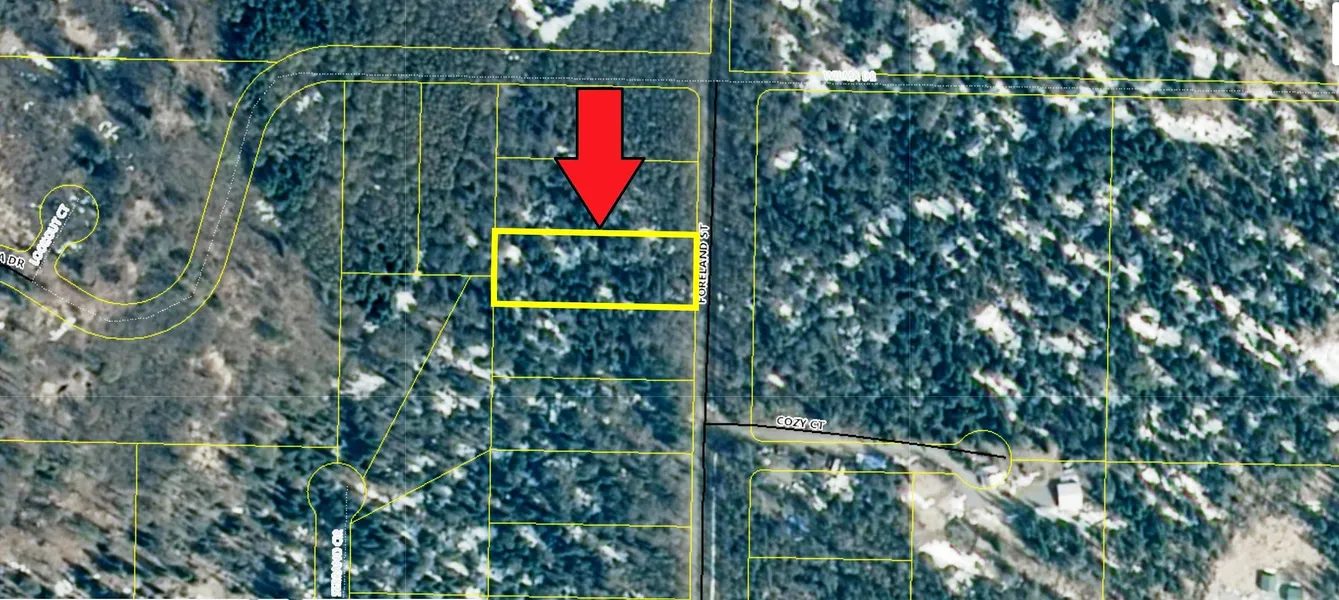
This lot is located in Nikiski on Foreland Road between mile posts 24 and 25 off of the Kenai Spur Highway. In the northern area of the Kenai Peninsula, this one acre parcel is perfect for building your getaway cabin or a permanent residence. The property can also be used as your recreational base camp.
Nikiski
Nikiski is an oil and gas town, with on-shore production facilities and offshore drilling platforms in Cook Inlet. Captain Cook State Recreation Area, a 3,460-acre state park nine miles north of Nikiski along Kenai Spur Highway, is the main draw for visitors to the area. This quiet state recreation area encompasses forests, lakes, rivers and wide beaches along Cook Inlet and features incredible views of the Alaska Range volcanoes.
Kenai Peninsula
The Kenai Peninsula is world renowned for its fishing, and the Kenai River is the centerpiece. There is no place in the world to fish like the rivers of the peninsula. In addition to the salmon fishing in the rivers, the Cook Inlet is also well known for crabbing and halibut fishing. Homer, on the south end of the peninsula, is known as the halibut capital of the world. The Kenai Peninsula is also well known for its hunting opportunities. It has a high density of black bears and offers big game hunters the opportunity to harvest moose, caribou, mountain goat, sheep, brown bear, and black bear.
The Kenai Peninsula offers limitless outdoor recreation opportunities including hiking, mountain biking, horseback riding, camping, wildlife viewing, backpacking, boating, snowshoeing, ATVing and snowmobiling.
Land Information:
Legal: Lot H, Subdivision of Lots 2 and 7, Opportunity Acres #1
APN: 01227013
Size: 1.00 Acres
Dimensions: 125.5' X 347.1'
GPS: Approximate GPS Coordinates
60.72173, -151.35294 (NW Corner)
60.72173, -151.35100 (NE Corner)
60.72139, -151.35100 (SE Corner)
60.72139, -151.35294 (SW Corner)
60.72156, -151.35194 (Center)
Owner financing available, please inquire. No credit checks, everyone qualifies. We accept all major credit cards. All cash offers are considered.
Document preparation fee: $299
Property ID: C-2021065-HFTT
From elevation to risk assessment
Search for detailed parcel information including; Elevation & Vegetation Maps, Ownership Information, Detailed Parcel Information, Crop History Map, Soil Survey Productivity Data, and more.
Research Parcel InformationEnvironmental Factors
Boise, ID
Land for Sale by Government Land Sales
Kenai Peninsula Borough Properties By Type
- Undeveloped Land for Sale in Kenai Peninsula Borough, Alaska
- Lakefront Property for Sale in Kenai Peninsula Borough, Alaska
- Riverfront Property for Sale in Kenai Peninsula Borough, Alaska
- Residential Property for Sale in Kenai Peninsula Borough, Alaska
- Commercial Property for Sale in Kenai Peninsula Borough, Alaska
- Beachfront Property for Sale in Kenai Peninsula Borough, Alaska
- Ranches for Sale in Kenai Peninsula Borough, Alaska
- Farms for Sale in Kenai Peninsula Borough, Alaska
- Hunting Land for Sale in Kenai Peninsula Borough, Alaska
- Recreational Property for Sale in Kenai Peninsula Borough, Alaska
- Horse Property for Sale in Kenai Peninsula Borough, Alaska
- Timberland for Sale in Kenai Peninsula Borough, Alaska
Properties for Sale Nearby Boroughs
Kenai Peninsula Borough Properties By City
- Anchor Point, Alaska Land for Sale
- Clam Gulch, Alaska Land for Sale
- Cooper Landing, Alaska Land for Sale
- Homer, Alaska Land for Sale
- Hope, Alaska Land for Sale
- Kasilof, Alaska Land for Sale
- Kenai, Alaska Land for Sale
- Moose Pass, Alaska Land for Sale
- Nikiski, Alaska Land for Sale
- Ninilchik, Alaska Land for Sale
- Seldovia, Alaska Land for Sale
- Seward, Alaska Land for Sale
- More
- Soldotna, Alaska Land for Sale
- Sterling, Alaska Land for Sale
- Tyonek, Alaska Land for Sale
- Fritz Creek, Alaska Land for Sale
- Halibut Cove, Alaska Land for Sale
- Nanwalek, Alaska Land for Sale
- Nikolaevsk, Alaska Land for Sale
- Port Graham, Alaska Land for Sale
- Bear Creek, Alaska Land for Sale
- Beluga, Alaska Land for Sale
- Chenik, Alaska Land for Sale
- Cohoe, Alaska Land for Sale
- Crown Point, Alaska Land for Sale
- Dahl, Alaska Land for Sale
- Diamond Ridge, Alaska Land for Sale
- Drift River, Alaska Land for Sale
- Falls, Alaska Land for Sale
- Fox River, Alaska Land for Sale
- Funny River, Alaska Land for Sale
- Gilpatricks, Alaska Land for Sale
- Happy Valley, Alaska Land for Sale
- Iniskin, Alaska Land for Sale
- Jakolof Bay, Alaska Land for Sale
- Kachemak City, Alaska Land for Sale
- Kachemak Silo, Alaska Land for Sale
- Kalifornsky, Alaska Land for Sale
- Kluchevaya, Alaska Land for Sale
- Klutchevya, Alaska Land for Sale
- Kustatan, Alaska Land for Sale
- Lawing, Alaska Land for Sale
- Lowell Point, Alaska Land for Sale
- Millers Landing, Alaska Land for Sale
- Muskwa Village, Alaska Land for Sale
- Nahodka, Alaska Land for Sale
- Nahotka, Alaska Land for Sale
- Naptowne, Alaska Land for Sale
- Nikishka, Alaska Land for Sale
- Old Tyonek, Alaska Land for Sale
- Point Possession, Alaska Land for Sale
- Port Nikiski, Alaska Land for Sale
- Primrose, Alaska Land for Sale
- Ridgeway, Alaska Land for Sale
- Salamatof, Alaska Land for Sale
- Seldovia Village, Alaska Land for Sale
- Shirleyville, Alaska Land for Sale
- Silvertip, Alaska Land for Sale
- Snug Harbor, Alaska Land for Sale
- Sunrise, Alaska Land for Sale
- Woodrow, Alaska Land for Sale