12.4-Acre Building Lot Near Lake Bomoseen, 4 Minutes to Beach
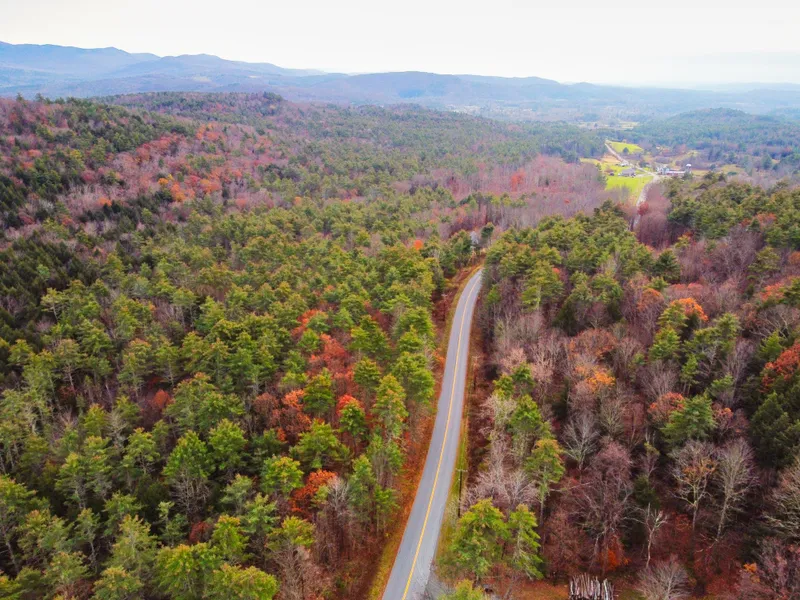
Over 12 acres in desirable Castleton, VT, known for Lake Bomoseen, one of the largest and cleanest in the state. This location is a 3 or 4 minute drive to Crystal Beach, which offers kayak rentals and passes for both residents and non-residents.
The parcel includes more than 600 feet of frontage on North Road, a quiet but important road that connects Crystal Beach to downtown Castleton. There are relatively flat areas near the roadside that would make the most convenient spots to build. Further in, the topography slopes down to an intermittent stream, then rises up once again to meet the rear boundary.
Castleton itself is a vibrant community, the most populous in the county, with restaurants, cafes, farm stands, and Vermont State University. There's easy access to countless hikes and recreational activities, not to mention skiing at either Killington or Okemo each 45 minutes away.
Asking Price: $78,000
Size: 12.43 acres
Address: North Road
Town: Castleton, VT 05735
SPAN: 129-040-12369
Property Tax (2023-2024 Calculated): $1,056.41
Coordinates: 43.64035, -73.17590
Perc Test: A past perc test showed viable soil on a flat area halfway between the roadside and the creek, however the written records are no longer available.
Water Supply: Well needed
Survey: No recent survey available.
RV Potential: Landowner may seek a trailer camp permit from the Development Review Board. Otherwise, landowner may park travel trailer on their own property in the rear or side yards, behind the front face of the principle building and no closer than six feet to any lot line. Trailer may not be used as living quarters or connected to any utilities.
Access: 645 feet of frontage on town-maintained paved road.
Association Dues: n/a
Terrain: Relatively flat near the road with some areas partially clear of trees. After that, topography dips to a low area with an intermittent stream which bisects the property north to south. Beyond that, topography rises up again before meeting the rear boundary.
Disclosure: Listing presented by contract-holder of the parcel described. Said contract is advertised herein.
From elevation to risk assessment
Search for detailed parcel information including; Elevation & Vegetation Maps, Ownership Information, Detailed Parcel Information, Crop History Map, Soil Survey Productivity Data, and more.
Research Parcel InformationLand for Sale by Christopher Snow
Rutland County Properties By Type
- Lakefront Property for Sale in Rutland County, Vermont
- Undeveloped Land for Sale in Rutland County, Vermont
- Beachfront Property for Sale in Rutland County, Vermont
- Riverfront Property for Sale in Rutland County, Vermont
- Farms for Sale in Rutland County, Vermont
- Commercial Property for Sale in Rutland County, Vermont
- Residential Property for Sale in Rutland County, Vermont
- Recreational Property for Sale in Rutland County, Vermont
- Hunting Land for Sale in Rutland County, Vermont
- Ranches for Sale in Rutland County, Vermont
- Timberland for Sale in Rutland County, Vermont
- Horse Property for Sale in Rutland County, Vermont
Properties for Sale Nearby Counties
Rutland County Properties By City
- Belmont, Vermont Land for Sale
- Benson, Vermont Land for Sale
- Bomoseen, Vermont Land for Sale
- Brandon, Vermont Land for Sale
- Castleton, Vermont Land for Sale
- Center Rutland, Vermont Land for Sale
- Chittenden, Vermont Land for Sale
- Cuttingsville, Vermont Land for Sale
- Danby, Vermont Land for Sale
- East Poultney, Vermont Land for Sale
- East Wallingford, Vermont Land for Sale
- Fair Haven, Vermont Land for Sale
- More
- Florence, Vermont Land for Sale
- Forest Dale, Vermont Land for Sale
- Hydeville, Vermont Land for Sale
- Killington, Vermont Land for Sale
- Middletown Springs, Vermont Land for Sale
- Mount Holly, Vermont Land for Sale
- North Clarendon, Vermont Land for Sale
- Pawlet, Vermont Land for Sale
- Pittsfield, Vermont Land for Sale
- Pittsford, Vermont Land for Sale
- Poultney, Vermont Land for Sale
- Proctor, Vermont Land for Sale
- Rutland, Vermont Land for Sale
- Wallingford, Vermont Land for Sale
- Wells, Vermont Land for Sale
- West Pawlet, Vermont Land for Sale
- West Rutland, Vermont Land for Sale
- Benson Landing, Vermont Land for Sale
- Blissville, Vermont Land for Sale
- Bowlsville, Vermont Land for Sale
- Chippenhook, Vermont Land for Sale
- Clarendon, Vermont Land for Sale
- Clarendon Springs, Vermont Land for Sale
- Crystal Beach, Vermont Land for Sale
- East Hubbardton, Vermont Land for Sale
- East Pittsford, Vermont Land for Sale
- East Rupert, Vermont Land for Sale
- Goshen, Vermont Land for Sale
- Healdville, Vermont Land for Sale
- Hortonville, Vermont Land for Sale
- Hubbardton, Vermont Land for Sale
- Leicester, Vermont Land for Sale
- Mendon, Vermont Land for Sale
- Mount Tabor, Vermont Land for Sale
- Neshobe Beach, Vermont Land for Sale
- North Chittenden, Vermont Land for Sale
- North Pawlet, Vermont Land for Sale
- North Rupert, Vermont Land for Sale
- North Shrewsbury, Vermont Land for Sale
- Russellville, Vermont Land for Sale
- Scottsville, Vermont Land for Sale
- Shrewsbury, Vermont Land for Sale
- South End, Vermont Land for Sale
- South Poultney, Vermont Land for Sale
- South Wallingford, Vermont Land for Sale
- Sudbury, Vermont Land for Sale
- Tinmouth, Vermont Land for Sale
- West Castleton, Vermont Land for Sale
- West Haven, Vermont Land for Sale
- Alfrecha, Vermont Land for Sale
- Avalon Beach, Vermont Land for Sale
- Blue Ridge Acres, Vermont Land for Sale
- Brewers Corner, Vermont Land for Sale
- Burnham Hollow, Vermont Land for Sale
- Butternut, Vermont Land for Sale
- Castleton Corners, Vermont Land for Sale
- Chasanna Acres, Vermont Land for Sale
- Cold River, Vermont Land for Sale
- Cold Spring, Vermont Land for Sale
- Danby Four Corners, Vermont Land for Sale
- Durgy Hill Heights, Vermont Land for Sale
- East Clarendon, Vermont Land for Sale
- East Wells, Vermont Land for Sale
- Eastridge Acres, Vermont Land for Sale
- Gorhamtown, Vermont Land for Sale
- Grandview Acres, Vermont Land for Sale
- Grangerville, Vermont Land for Sale
- Green Acres, Vermont Land for Sale
- Hortonia, Vermont Land for Sale
- Hyde Manor, Vermont Land for Sale
- Ira, Vermont Land for Sale
- Killington Heights, Vermont Land for Sale
- Killington Village, Vermont Land for Sale
- Marolin Acres, Vermont Land for Sale
- Michigan, Vermont Land for Sale
- Mount Holly Heights, Vermont Land for Sale
- Mount Pleasant, Vermont Land for Sale
- North Sherburne, Vermont Land for Sale
- Pierces Corner, Vermont Land for Sale
- Pinecrest Acres, Vermont Land for Sale
- Pinnacle Ridge, Vermont Land for Sale
- Point of Pines, Vermont Land for Sale
- Prospect Hill, Vermont Land for Sale
- Ransomvale, Vermont Land for Sale
- Sherburne Center, Vermont Land for Sale
- South Sherburne, Vermont Land for Sale
- Stacy Crossroads, Vermont Land for Sale
- Sugar Hollow, Vermont Land for Sale
- Sugarwood Hill, Vermont Land for Sale
- Tarbellville, Vermont Land for Sale
- Telemark Village, Vermont Land for Sale
- The Woods, Vermont Land for Sale
- West Tinmouth, Vermont Land for Sale