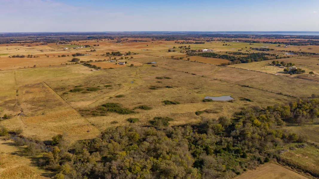
80 acres- Farm Land in Nowata, OK
80 acres with 95% usable pasture. Has 2 ponds and a year round creek. Excellent candidate for FSA 50/50 loan. Additional 20 acres within 2 miles of this property.
Legal: The S/2 OF THE NW/4 OF THE SW/4 AND THE SW/4 OF THE NE/4 OF THE SW/4 AND THE N/2 OF THE NW/4 OF THE SE/4 OF THE SW/4 AND THE E/2 OF THE SE/4 OF THE SW/4 AND THE SW/4 OF THE SW/4 OF THE SE/4 AND THE S/2 OF THE NW/4 OF THE SW/4 OF THE SE/4 ALL IN SECTION 20, T26N, R16E, NOWATA COUNTY, OKLAHOMA.
Improvements: None
Water: Available- Rural
Utilities: Electric Available
Land:
Minerals: None
Production: Grazing
Soils:
44- Ac ScB Shidler-Claremore complex 1% to 3% slopes Class 4
19 Ac AeB Apperson silty clay loam 1% to 3% slopes Class 3
Alternative Uses/ Resources:
Leases: None
Hunting/Recreation: Whitetail deer & wild turkey hunting along the western branch of the Verdigris River.
Conservation Easements (CRP/WAP): None
Development Potential: (3) 10 acre home sites along county road 21.
Tax Advantage: Discount farm tag for truck & no sales tax on purchased farm supplies.
Climate History: The average annual temperature is 60 .
Days of 90 or higher: 66 days
Days of 20 or lower: 25 days
Precipitation: Average annual: 43.5 inches Days with precipitation: 87 days.
Winter Weather: Average annual snowfall: 8.8 inches Days with snow on ground: 8 days
First Freeze: October 30
Last Freeze: April 4
Growing Season: 208 days
Other Facts: Average wind speed 4 mph. Sunshine: 50-75% Average humidity: 72% Thunderstorm days: 51
Farm History: Grazing
Broker comments: 80 acres with 95% usable pasture. Has 2 ponds and a year round creek. Excellent candidate for FSA 50/50 loan. Additional 20 acres within 2 miles of this property.
Showing Instructions: Shown by appointment only. The seller requests that all interested parties have a pre-qual letter from their lending institution.
From elevation to risk assessment
Search for detailed parcel information including; Elevation & Vegetation Maps, Ownership Information, Detailed Parcel Information, Crop History Map, Soil Survey Productivity Data, and more.
Research Parcel InformationMore Land for Sale in Nowata County
Nowata County Properties By Type
- Residential Property for Sale in Nowata County, Oklahoma
- Farms for Sale in Nowata County, Oklahoma
- Undeveloped Land for Sale in Nowata County, Oklahoma
- Lakefront Property for Sale in Nowata County, Oklahoma
- Ranches for Sale in Nowata County, Oklahoma
- Hunting Land for Sale in Nowata County, Oklahoma
- Timberland for Sale in Nowata County, Oklahoma
- Recreational Property for Sale in Nowata County, Oklahoma
- Riverfront Property for Sale in Nowata County, Oklahoma
- Commercial Property for Sale in Nowata County, Oklahoma
- Horse Property for Sale in Nowata County, Oklahoma
- Beachfront Property for Sale in Nowata County, Oklahoma
Properties for Sale Nearby Counties
Nowata County Properties By City
- Delaware, Oklahoma Land for Sale
- Lenapah, Oklahoma Land for Sale
- Nowata, Oklahoma Land for Sale
- Wann, Oklahoma Land for Sale
- Coodys Bluff, Oklahoma Land for Sale
- Glenoak, Oklahoma Land for Sale
- Noxie, Oklahoma Land for Sale
- South Coffeyville, Oklahoma Land for Sale
- Watova, Oklahoma Land for Sale
- Alluwe, Oklahoma Land for Sale
- Childers, Oklahoma Land for Sale
- Elliott, Oklahoma Land for Sale
- More