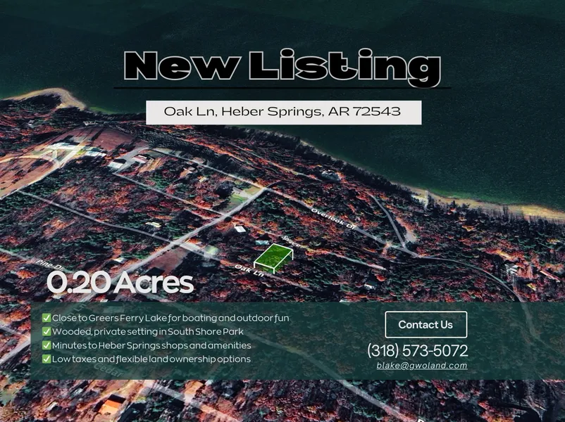
Wooded 0.20-Acre Lot in Heber Springs’ South Shore Park
Escape to the serene beauty of Heber Springs, Arkansas, with this 0.20-acre lot in the South Shore Park subdivision. Nestled on Oak Ln, this wooded property offers a steep, private setting with elevations ranging from 630 to 670 feet, providing a quiet retreat in a natural forested environment. Whether you dream of building a cozy cabin, weekend getaway, or simply holding it as an investment, this lot offers the peace and flexibility you’re looking for.
The property is conveniently located near the charming town of Heber Springs, providing easy access to shopping, dining, and local amenities. Outdoor enthusiasts will love being just minutes from Greers Ferry Lake, a popular destination for boating, fishing, and lakeside recreation, as well as nearby hiking trails, parks, and scenic viewpoints. Little Rock sits roughly 80 miles south, making it an easy drive for weekend trips to the city while still enjoying the tranquility of rural Arkansas.
This lot offers a chance to enjoy the natural landscape of Cleburne County, with mature trees, rolling hills, and a quiet, community-focused neighborhood. With gravel road access and residential zoning under county regulations, you have the freedom to build your dream retreat or vacation cabin. Low property taxes and a desirable location near major attractions make this lot both an appealing lifestyle choice and a smart investment in the Heber Springs area.
Property Details:
Assessor's Parcel Number: Parcel id 002-08988-000 (208988000)
Property Address: Oak Ln, Heber Springs, AR 72543
County, State: Cleburne, AR
Subdivision: South Shore Park
Lot Number: 200
Legal Description: South Shore Park Lot 200
TRS: T10N R11W SEC 25
Parcel Size: 0.20 acres
Terrain Type: Steep Slope, Wooded
Lot Dimensions: 75 ft x 120 ft
Elevation: 630 ft - 670 ft
Access To Property: Oak Ln
Road Type: Gravel
Zoning / Property Use Code: Per County, No Zoning / Per CC&R's, Residential
GPS Coordinates (Center): 35.46631, -92.11448
GPS Coordinates (4 corners):
35.4665, -92.1144 NE
35.4661, -92.1144 SE
35.4661, -92.1146 SW
35.4665, -92.1146 NW
From elevation to risk assessment
Search for detailed parcel information including; Elevation & Vegetation Maps, Ownership Information, Detailed Parcel Information, Crop History Map, Soil Survey Productivity Data, and more.
Research Parcel InformationDirections
Follow Pearson Rd west, take a right at the T onto Lake Ln. Follow Lake Lane to Pine Dr, and take a left. Take a right on Lynn Ln, then another right onto Oak Ln.
Land for Sale by Laurie Halter
Cleburne County Properties By Type
- Hunting Land for Sale in Cleburne County, Arkansas
- Farms for Sale in Cleburne County, Arkansas
- Undeveloped Land for Sale in Cleburne County, Arkansas
- Riverfront Property for Sale in Cleburne County, Arkansas
- Lakefront Property for Sale in Cleburne County, Arkansas
- Ranches for Sale in Cleburne County, Arkansas
- Residential Property for Sale in Cleburne County, Arkansas
- Timberland for Sale in Cleburne County, Arkansas
- Recreational Property for Sale in Cleburne County, Arkansas
- Horse Property for Sale in Cleburne County, Arkansas
- Commercial Property for Sale in Cleburne County, Arkansas
- Beachfront Property for Sale in Cleburne County, Arkansas
Properties for Sale Nearby Counties
Cleburne County Properties By City
- Concord, Arkansas Land for Sale
- Drasco, Arkansas Land for Sale
- Edgemont, Arkansas Land for Sale
- Heber Springs, Arkansas Land for Sale
- Higden, Arkansas Land for Sale
- Ida, Arkansas Land for Sale
- Prim, Arkansas Land for Sale
- Quitman, Arkansas Land for Sale
- Tumbling Shoals, Arkansas Land for Sale
- Wilburn, Arkansas Land for Sale
- Brewer, Arkansas Land for Sale
- Greers Ferry, Arkansas Land for Sale
- More
- Hiram, Arkansas Land for Sale
- Mcjester, Arkansas Land for Sale
- Pearson, Arkansas Land for Sale
- Wolf Bayou, Arkansas Land for Sale
- Woodrow, Arkansas Land for Sale
- Almond, Arkansas Land for Sale
- Banner, Arkansas Land for Sale
- Brownsville, Arkansas Land for Sale
- Budd Creek, Arkansas Land for Sale
- Driftwood Shores, Arkansas Land for Sale
- Fivemile, Arkansas Land for Sale
- Lake Ridge, Arkansas Land for Sale
- Partain, Arkansas Land for Sale
- Post Oak, Arkansas Land for Sale
- Rainbow Island, Arkansas Land for Sale
- Sandiff, Arkansas Land for Sale
- Snell, Arkansas Land for Sale
- South Shore Park, Arkansas Land for Sale
- Sunny Slope, Arkansas Land for Sale
- Tannenbaum, Arkansas Land for Sale
- West Pangburn, Arkansas Land for Sale
- Whispering Springs, Arkansas Land for Sale
