Invest in this 80-Acre Rough Diamond in Botetourt County, VA!
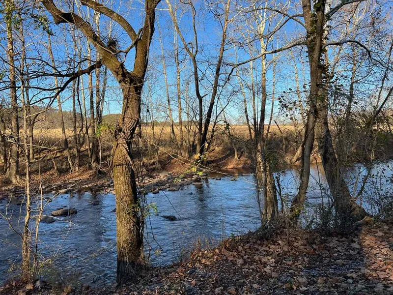
This property checks so many boxes with 80 acres of mature woods, springs, access to Craig Creek and James River, and an open canvas for all your ideas and aspirations! Country living has become a popular choice for those looking for a spot to vacation or for those who are simply tired of the noise and turmoil of life in the city. If you are one of those people, this pristine 80-Acre gem is perfect for your next investment scheme! Build a getaway cabin, keep a bank of land ready for a retreat at any time, or build a home, all while the timber investment grows and you enjoy the rolling mountains of Virginia and the blue waterways cutting through them.
A timber cruise done in 2017 showed $90,000 of timber value. This property is not in a Conservation Easement, so that would be an option for a savvy investor. Also comes with deeded access to Craig Creek just above where it meets the James River, setting you up for all kinds of water adventures, including tubing, canoeing, and other boat opportunities on the James River.
This hidden paradise offers a blank canvas of opportunity for your next investment and the road access makes downtown Roanoke just minutes away. Invest in this 80-acre lot surrounded by the raw wilderness of Botetourt County. Your quiet seclusion shouldnt come pricey and restocking for daily supplies should be easy. This lot is sure to attract a number of homeowners and savvy investors in no time! Whether it's for a long-term investment or for your weekend getaways/stay-cation, this lot definitely delivers!
Call now before it's gone!
Better Land Co Listing Attributes:
Cash Price: $189,900
County, State: Botetourt County, VA
Acres: 80.28 Acres
GPS Coordinates: 37.642668, -79.814157
GPS Coordinates (36 Corners):
37.6433, -79.8095
37.6434, -79.8104
37.6438, -79.8114
37.6441, -79.8135
37.644, -79.8146
37.6444, -79.8152
37.6444, -79.8159
37.6448, -79.8159
37.6448, -79.8161
37.6449, -79.8166
37.6449, -79.8169
37.645, -79.817
37.6449, -79.8174
37.6445, -79.8177
37.6446, -79.8175
37.6443, -79.8173
37.6441, -79.8173
37.644, -79.8179
37.644, -79.8182
37.6444, -79.8183
37.6443, -79.819
37.6442, -79.8188
37.644, -79.8187
37.644, -79.8197
37.6451, -79.8202
37.645, -79.8204
37.645, -79.8208
37.6379, -79.8187
37.6379, -79.8184
37.6382, -79.8179
37.6385, -79.8171
37.6391, -79.8163
37.6396, -79.8149
37.6401, -79.8139
37.6409, -79.8123
37.6413, -79.8116
Parcel Number: 27-18
Legal Description: James River
Elevation: 1299.2 FT
Information and photos are deemed reliable, but not guaranteed. Photos may be of the area and not the exact property. No representations as to fitness for a particular purpose have been made. No verbal claims or promises have been made to Buyer. Buyer is not relying on Seller as to the condition of the property. Buyer acknowledges that the Property is acceptable to them in its presently existing condition. Buyer to rely on its own due diligence. All sales are final.
From elevation to risk assessment
Search for detailed parcel information including; Elevation & Vegetation Maps, Ownership Information, Detailed Parcel Information, Crop History Map, Soil Survey Productivity Data, and more.
Research Parcel InformationResources
Land for Sale by Benjamin Harris
Botetourt County Properties By Type
- Farms for Sale in Botetourt County, Virginia
- Undeveloped Land for Sale in Botetourt County, Virginia
- Residential Property for Sale in Botetourt County, Virginia
- Hunting Land for Sale in Botetourt County, Virginia
- Riverfront Property for Sale in Botetourt County, Virginia
- Lakefront Property for Sale in Botetourt County, Virginia
- Ranches for Sale in Botetourt County, Virginia
- Commercial Property for Sale in Botetourt County, Virginia
- Recreational Property for Sale in Botetourt County, Virginia
- Timberland for Sale in Botetourt County, Virginia
- Horse Property for Sale in Botetourt County, Virginia
- Beachfront Property for Sale in Botetourt County, Virginia
Properties for Sale Nearby Counties
Botetourt County Properties By City
- Blue Ridge, Virginia Land for Sale
- Buchanan, Virginia Land for Sale
- Cloverdale, Virginia Land for Sale
- Daleville, Virginia Land for Sale
- Eagle Rock, Virginia Land for Sale
- Fincastle, Virginia Land for Sale
- Glen Wilton, Virginia Land for Sale
- Oriskany, Virginia Land for Sale
- Troutville, Virginia Land for Sale
- Haymakertown, Virginia Land for Sale
- Hollins, Virginia Land for Sale
- Lithia, Virginia Land for Sale
- More
- Amsterdam, Virginia Land for Sale
- Apple Tree Village, Virginia Land for Sale
- Arcadia, Virginia Land for Sale
- Baldwin, Virginia Land for Sale
- Bessemer, Virginia Land for Sale
- Botetourt East, Virginia Land for Sale
- British Woods, Virginia Land for Sale
- Coyner Mountain Overlook, Virginia Land for Sale
- Coyner Springs, Virginia Land for Sale
- Daggers Springs, Virginia Land for Sale
- Dillon, Virginia Land for Sale
- Fork Mountain, Virginia Land for Sale
- Gala, Virginia Land for Sale
- Glebe Mills, Virginia Land for Sale
- Greyledge, Virginia Land for Sale
- Haden, Virginia Land for Sale
- Harvey, Virginia Land for Sale
- Heatherstone, Virginia Land for Sale
- Hipes, Virginia Land for Sale
- Howell Mills, Virginia Land for Sale
- Kyles Mills, Virginia Land for Sale
- Laymantown, Virginia Land for Sale
- Lignite, Virginia Land for Sale
- Mount Union, Virginia Land for Sale
- Munford, Virginia Land for Sale
- Nace, Virginia Land for Sale
- Oldfields, Virginia Land for Sale
- Parr, Virginia Land for Sale
- Pico, Virginia Land for Sale
- Rocky Point, Virginia Land for Sale
- Runaway Village, Virginia Land for Sale
- Salisbury, Virginia Land for Sale
- Solitude, Virginia Land for Sale
- Spec, Virginia Land for Sale
- Springwood, Virginia Land for Sale
- Stepping Stone, Virginia Land for Sale
- Strom, Virginia Land for Sale
- Surber, Virginia Land for Sale
- Trinity, Virginia Land for Sale
- Webster, Virginia Land for Sale