LAUREL CREEK FARM
Laurel Creek Farm 109 +/- acres has it all - field, wood, and water in the heart of the New River Gorge recreation area.
Agent Contact:Richard Grist, (304) 6457674
OVERVIEW
Laurel Creek Farm is located in the heart of white water rafting country the New River Gorge, which is considered the gateway to water recreation.
HIGHLIGHTS
A mixture of mature hardwood forest and old fields create excellent wildlife habitat
Long views of distant mountains and valleys below
Numerous recreational opportunities exist in this area
The mighty New River is just a 10 minute drive for all water recreational opportunities
Easy access via I-64 and I-77
Access to airports in nearby Beckley, Charleston and Lewisburg
Dark skies for star gazing and planet observation
All mineral rights the seller has will convey
Over mile of Laurel Creek runs through the farm
Ancient heritage trees scattered across the property, some dating to the 1800s
Miles of interior trails for ATVing, horseback riding, and hiking.
Surrounded by timber tracts and cattle farms in a nice rural neighborhood.
Superior access adjoining paved state road on school bus route, FedEx delivery
Boone and Crocket country with exceptional resident wildlife populations
Electric and phone on site
Well and septic
Excellent timber value with beautiful oaks, walnuts, poplars, maples and hickories
All mineral rights the seller owns will convey
Winged wildlife includes eagles, hawks, owls, ravens, and Neotropical songbirds
Diverse topography of forest, bogs and meadows create an interesting natural setting.
Elevations run from 1558 to 2368.
DESCRIPTION
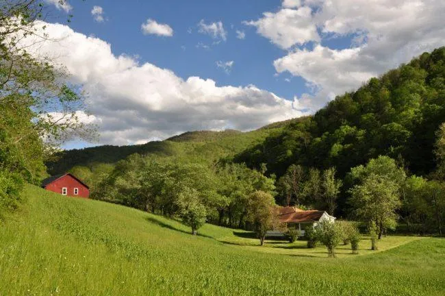
Laurel Creek Farm and attendant 109 +/- acres offers an excellent hiking, hunting and other recreational opportunities within a mature mountain forest setting. This property is located near the small farming community of Ramp, in the shadows of Keeny Mountain in the ever popular Summers County WV.
There is a 1,298 sq. ft. home and large barn located on the property. The land around the house is level to rolling and suitable for additional buildings and large garden spots. A well and septic are in place as well as power. There is an abundant deer, grouse, squirrel and turkey population.
Laurel Creek Farm is an easy 10 minute drive on paved roads to Interstate 64 at the Sandstone interchange. Beckley and Lewisburg offer shopping, schools, theaters, modern medical facilities and airports within a 30-40 minute drive. A well-stocked country store is a 10 minute drive located at Sandstone on the New River.
Within an hour are located some of the finest recreational facilities in West Virginia. Winterplace Ski Resort, whitewater rafting/fishing on the New River and Gauley River, 2000 acre Bluestone Lake, Pipestem State Park and Resort and the 80,000 acre New River National Gorge National Park. Five other area state parks and state forests offer unlimited hiking, horseback riding, ATV riding and rock climbing opportunities.
AREA
The Gorge cradles the New River, one of the worlds oldest. It offers every level of whitewater sports, from jet boats to rafting, kayaking and SUPs. The Gorge is known for its world class rock climbing, fishing, hiking, camping, mountain biking and ziplines. There are 3 National Parks here, plus 10 State Parks in this, the 3rd most forested state in the US and is home to more than 1,400 species of plants and diverse wildlife.
HOME INFORMATION
Home Dimensions:
Total square feet living area 1,298+/-
Covered front porch 6x40
Side porch 6x16
Back porch 6x12
Room Dimensions:
Kitchen 11x13
Dining 11x13
Bedroom #1 11x13
Bedroom #2 11x13
Bedroom #3 13x13
Den 13x13
Mud room 4x7
Bath 8x8
Powder room 5x5
Bathroom 5x10
Outbuildings:
Barn 28x40
Loft 9x40
THE FOREST
There is about 19 acres of open land with the balance in forest. There are some nice trails in place to enjoy a quite walk on. Some of the forest was in fields prior to WWII and large piles of field stone and split rail fence are found along the old field edges. These stone piles and fences are a lasting testament of the backbreaking work the early mountaineers put in to create a homestead.
Beechnuts, Hickory nuts, sweet White Oak and Red Oak Acorns provide a sustainable food source for the squirrels, chipmunks, whitetail deer and wild turkey that live in abundance in the forest.
Many species of songbirds and woodpeckers thrive in the special habitat that large older trees and younger emerging stands and make their home in this special forest environ. It is exciting to see and hear the large and very vocal Pileated Woodpecker, with its bright red crest dressed in a black and white tuxedo, sweep through the tall canopy in search of a morning snack.
LOCATION
Google Coordinates: 37.7586083(N), -80.8536917(W)
(374530.99N, 805113.29W)
Address: Ramp Road, Hinton, WV 25951
Elevation Range: 1558 ft. to 2368 ft. +/-
WATER
Over mile of Laurel Creek runs through the farm.
MINERAL RESOURCES
All rights the owner has will convey with the property.
BOUNDARIES AND SURVEY
A property boundary survey was performed in 2009, and a survey plat was recorded in the county courthouse. Portions of the property boundaries run with state roads and Laurel Creek. The property is being sold by the boundary and not by the acre.
ACCESS/FRONTAGE
The farm has over a mile of combined frontage on Ramp Road WV RT 7 and Wingfield Mtn. Road WV RT 7/4, providing direct access to the public road system.
UTILITIES
Water: Well
Sewer: Septic
Electricity: On site
Telephone: On site
Cellphone Coverage: Good
ZONING
Summers County currently has no known zoning or subdivision regulations. However, all prospective buyers should consult the County Government and also the Health Department for any changes and details regarding zoning, building codes, and installation of septic systems.
PROPERTY TYPE/USE SUMMARY
The property is devoted to pasture fields, forestland, and the home area. A breakdown as determined from aerial is as follows:
Home Area and Pasture fields: 19 acres +/-
Forestland: 87 acres +/-
Roads and Laurel Creek: 3 acres +/-
(This summary is only an estimation of current property use as determined from aerial photography. It is made subject to the estimation of property boundaries and any errors in the interpretation of land use type from the aerial photography utilized.)
DEED AND TAX INFORMATION
Deed Information: Deed Book 232, Page 609; Survey Plat recorded as Plat File B-154A
Summers County, West Virginia
Deed Acreage: 109.367 acres +/-
Real Estate Tax ID/Acreage/Taxes:
Summers County (45), West Virginia
Green Sulphur District (3)
TM 13 Parcel 23; 80 ACRES 25 POLES LAUREL CREEK; Class 2; 2016 Taxes $513.53
TM 13 Parcel 55; 40 ACRES LAUREL CREEK; Class 2; 2016 Taxes $126.36
2016 Real Estate Taxes: $639.89
SCHOOLS
Summers County School District:
Hinton Area Elementary School
Summers County Middle School
Summers County High School
DIRECTIONS
From Lewisburg: 36 Miles +/-
From Lewisburg Ronceverte I-64 interchange No. 169, travel I-64 West for approximately 30.7 miles to Sandstone/Hinton Exit 139; at the end of the exit ramp turn left towards RT 20, at the intersection with RT 20, continue straight to travel RT 20 South towards Hinton for 6/10 mile, turn left onto Ramp Road RT 7; travel Ramp Road for 2.7 miles to the intersection with Wingfield Mtn. Rd. RT 7/4; the farm is on the right.
From Beckley: 21 Miles +/-
From Beckley Eisenhower Dr. I-64 interchange No. 124, travel I-64 East for approximately 14.3 mi. to Sandstone/Hinton Exit 139; at the end of the exit ramp turn left towards RT 20, at the intersection with RT 20, continue straight to travel RT 20 South towards Hinton for 6/10 mile, turn left onto Ramp Road RT 7; travel Ramp Road for 2.7 miles to the intersection with Wingfield Mtn. Rd. RT 7/4; the farm is on the right.
From Hinton: 12 Miles +/-
From Hinton, travel RT 20 North for approximately 9.5 mi. to the community of Sandstone, turn right onto Ramp Road RT 7; travel Ramp Road for 2.7 miles to the intersection with Wingfield Mtn. Rd. RT 7/4; the farm is on the right.
From elevation to risk assessment
Search for detailed parcel information including; Elevation & Vegetation Maps, Ownership Information, Detailed Parcel Information, Crop History Map, Soil Survey Productivity Data, and more.
Research Parcel InformationDirections
From Lewisburg: 36 Miles +/-
From Lewisburg Ronceverte I-64 interchange No. 169, travel I-64 West for approximately 30.7 miles to Sandstone/Hinton Exit 139; at the end of the exit ramp turn left towards RT 20, at the intersection with RT 20, continue straight to travel RT 20 South towards Hinton for 6/10 mile, turn left onto Ramp Road RT 7; travel Ramp Road for 2.7 miles to the intersection with Wingfield Mtn. Rd. RT 7/4; the farm is on the right.
From Beckley: 21 Miles +/-
From Beckley Eisenhower Dr. I-64 interchange No. 124, travel I-64 East for approximately 14.3 mi. to Sandstone/Hinton Exit 139; at the end of the exit ramp turn left towards RT 20, at the intersection with RT 20, continue straight to travel RT 20 South towards Hinton for 6/10 mile, turn left onto Ramp Road RT 7; travel Ramp Road for 2.7 miles to the intersection with Wingfield Mtn. Rd. RT 7/4; the farm is on the right.
From Hinton: 12 Miles +/-
From Hinton, travel RT 20 North for approximately 9.5 mi. to the community of Sandstone, turn right onto Ramp Road RT 7; travel Ramp Road for 2.7 miles to the intersection with Wingfield Mtn. Rd. RT 7/4; the farm is on the right.
Land for Sale by Richard Grist
Summers County Properties By Type
- Hunting Land for Sale in Summers County, West Virginia
- Riverfront Property for Sale in Summers County, West Virginia
- Farms for Sale in Summers County, West Virginia
- Lakefront Property for Sale in Summers County, West Virginia
- Commercial Property for Sale in Summers County, West Virginia
- Recreational Property for Sale in Summers County, West Virginia
- Undeveloped Land for Sale in Summers County, West Virginia
- Residential Property for Sale in Summers County, West Virginia
- Timberland for Sale in Summers County, West Virginia
- Ranches for Sale in Summers County, West Virginia
- Horse Property for Sale in Summers County, West Virginia
- Beachfront Property for Sale in Summers County, West Virginia
Properties for Sale Nearby Counties
Summers County Properties By City
- Forest Hill, West Virginia Land for Sale
- Green Sulphur Springs, West Virginia Land for Sale
- Hinton, West Virginia Land for Sale
- Jumping Branch, West Virginia Land for Sale
- Meadow Creek, West Virginia Land for Sale
- Nimitz, West Virginia Land for Sale
- Pence Springs, West Virginia Land for Sale
- Pipestem, West Virginia Land for Sale
- Sandstone, West Virginia Land for Sale
- Talcott, West Virginia Land for Sale
- Ballengee, West Virginia Land for Sale
- Brooks, West Virginia Land for Sale
- More
- Indian Mills, West Virginia Land for Sale
- Lovern, West Virginia Land for Sale
- Streeter, West Virginia Land for Sale
- True, West Virginia Land for Sale
- Avis, West Virginia Land for Sale
- Bargers Springs, West Virginia Land for Sale
- Barksdale, West Virginia Land for Sale
- Barnettown, West Virginia Land for Sale
- Bellepoint, West Virginia Land for Sale
- Bertha, West Virginia Land for Sale
- Beurytown, West Virginia Land for Sale
- Brooklin, West Virginia Land for Sale
- Browning, West Virginia Land for Sale
- Buck, West Virginia Land for Sale
- Carew, West Virginia Land for Sale
- Clayton, West Virginia Land for Sale
- Crumps Bottom, West Virginia Land for Sale
- Ellison, West Virginia Land for Sale
- Ellison Ridge, West Virginia Land for Sale
- Farley, West Virginia Land for Sale
- Glenray, West Virginia Land for Sale
- Griffith Creek, West Virginia Land for Sale
- Hill Top, West Virginia Land for Sale
- Hilldale, West Virginia Land for Sale
- Hix, West Virginia Land for Sale
- Judson, West Virginia Land for Sale
- Lick Creek, West Virginia Land for Sale
- Lowell, West Virginia Land for Sale
- Mandeville, West Virginia Land for Sale
- Marie, West Virginia Land for Sale
- Neponset, West Virginia Land for Sale
- Ramp, West Virginia Land for Sale
- Riffe, West Virginia Land for Sale
- Santafee, West Virginia Land for Sale
- Suck Creek, West Virginia Land for Sale
- Tempa, West Virginia Land for Sale
- Valley Heights, West Virginia Land for Sale
- Wiggins, West Virginia Land for Sale