RED ROCK
RED ROCK at Forest Hill 2 Acres with drilled well, septic and electric in place. Deeded access to the Greenbrier River just a few feet from the lot! Ready to build or enjoy right away. Includes 33 Foot 1987 Citation Travel Trailer. Also includes a separate Slide in Camper. Nice level lot part clear, part wooded. Many flowering ornamentals, evergreens and walnut trees.
Enjoy the description below, and be sure to catch the photos and maps. To follow-up on your interest, call Agent Contact: Joyce L. Surbaugh, 304.660.8000 or 304.645.7674.
LOCATION
Google Coordinates: 37.612676(N), -80.776576(W)
Address: Red Rock Drive, Forest Hill, WV 24935
Elevation: 1443 ft. +/-
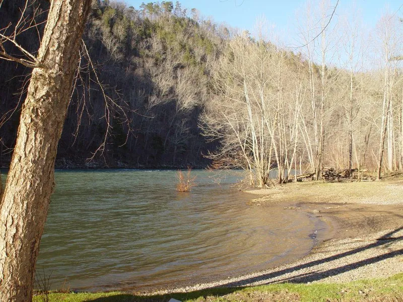
WATER
Red Rock has deeded access to the Greenbrier River for enjoyment of the river recreational benefits.
MINERAL RESOURCES
West Virginia is one of the states in the US that has two ownership titles, those being SURFACE RIGHTS and MINERAL RIGHTS. A title search for mineral rights ownership has not been conducted. All rights the owner has will convey with the property. A mineral title search could be conducted by a title attorney at the same time when the surface title search is being conducted.
BOUNDARIES AND SURVEY
This property was created as part of a subdivision, and a metes and bounds description were created by boundary survey. Those metes and bounds have been used in the owners deed. The property is being sold by the boundary and not by the acre.
ACCESS/FRONTAGE
The property is accessed by subdivision roads, which provide access to the public road system.
ZONING
Summers County currently has no known zoning or subdivision regulations. However, all prospective buyers should consult the County Government and also the Health Department for any changes and details regarding zoning, building codes, and installation of water wells and septic systems.
DEED AND TAX INFORMATION
Deed Information: DB 178 Pg. 409
Summers County, West Virginia
Acreage: 2.00 acres +/-
Real Estate Tax ID/Acreage/Taxes:
Summers County (45), West Virginia
Forest Hill District (1)
Tax Map 4 Parcel 1.35; 2.00 ACRES LOT A-10 RED ROCK MEADOW SECTION; Class 3; 2018 Real Estate Taxes: $78.22
2018 Total Real Estate Taxes: $78.22
PUBLIC SCHOOLS
Summers County School District
Public Elementary Schools:
Hinton Area Elementary School
Talcott Elementary School
Public Middle School:
Summers County Middle School
Public High School:
Summers County High School
DIRECTIONS
From Alderson Drive 12 miles to Talcott go left on Rt 17 across the river. Drive 3.5 miles on rt. 17 pass Doc Fox Rd. At Co Rt. 29 Bear Right. Drive about 1 mile to Red Rock Drive on the right. Drive 200 yards. Turn Right look For Foxfire sign and lot on the left just before the campground.
From elevation to risk assessment
Search for detailed parcel information including; Elevation & Vegetation Maps, Ownership Information, Detailed Parcel Information, Crop History Map, Soil Survey Productivity Data, and more.
Research Parcel InformationDirections
From Alderson Drive 12 miles to Talcott go left on Rt 17 across the river. Drive 3.5 miles on rt. 17 pass Doc Fox Rd. At Co Rt. 29 Bear Right. Drive about 1 mile to Red Rock Drive on the right. Drive 200 yards. Turn Right look For Foxfire sign and lot on the left just before the campground.
Land for Sale by Richard Grist
Summers County Properties By Type
- Hunting Land for Sale in Summers County, West Virginia
- Riverfront Property for Sale in Summers County, West Virginia
- Farms for Sale in Summers County, West Virginia
- Lakefront Property for Sale in Summers County, West Virginia
- Commercial Property for Sale in Summers County, West Virginia
- Recreational Property for Sale in Summers County, West Virginia
- Undeveloped Land for Sale in Summers County, West Virginia
- Residential Property for Sale in Summers County, West Virginia
- Timberland for Sale in Summers County, West Virginia
- Horse Property for Sale in Summers County, West Virginia
- Ranches for Sale in Summers County, West Virginia
- Beachfront Property for Sale in Summers County, West Virginia
Properties for Sale Nearby Counties
Summers County Properties By City
- Forest Hill, West Virginia Land for Sale
- Green Sulphur Springs, West Virginia Land for Sale
- Hinton, West Virginia Land for Sale
- Jumping Branch, West Virginia Land for Sale
- Meadow Creek, West Virginia Land for Sale
- Nimitz, West Virginia Land for Sale
- Pence Springs, West Virginia Land for Sale
- Pipestem, West Virginia Land for Sale
- Sandstone, West Virginia Land for Sale
- Talcott, West Virginia Land for Sale
- Ballengee, West Virginia Land for Sale
- Brooks, West Virginia Land for Sale
- More
- Indian Mills, West Virginia Land for Sale
- Lovern, West Virginia Land for Sale
- Streeter, West Virginia Land for Sale
- True, West Virginia Land for Sale
- Avis, West Virginia Land for Sale
- Bargers Springs, West Virginia Land for Sale
- Barksdale, West Virginia Land for Sale
- Barnettown, West Virginia Land for Sale
- Bellepoint, West Virginia Land for Sale
- Bertha, West Virginia Land for Sale
- Beurytown, West Virginia Land for Sale
- Brooklin, West Virginia Land for Sale
- Browning, West Virginia Land for Sale
- Buck, West Virginia Land for Sale
- Carew, West Virginia Land for Sale
- Clayton, West Virginia Land for Sale
- Crumps Bottom, West Virginia Land for Sale
- Ellison, West Virginia Land for Sale
- Ellison Ridge, West Virginia Land for Sale
- Farley, West Virginia Land for Sale
- Glenray, West Virginia Land for Sale
- Griffith Creek, West Virginia Land for Sale
- Hill Top, West Virginia Land for Sale
- Hilldale, West Virginia Land for Sale
- Hix, West Virginia Land for Sale
- Judson, West Virginia Land for Sale
- Lick Creek, West Virginia Land for Sale
- Lowell, West Virginia Land for Sale
- Mandeville, West Virginia Land for Sale
- Marie, West Virginia Land for Sale
- Neponset, West Virginia Land for Sale
- Ramp, West Virginia Land for Sale
- Riffe, West Virginia Land for Sale
- Santafee, West Virginia Land for Sale
- Suck Creek, West Virginia Land for Sale
- Tempa, West Virginia Land for Sale
- Valley Heights, West Virginia Land for Sale
- Wiggins, West Virginia Land for Sale