40 Acres in Montana
Amazing opportunity to own a huge 40-Acre property in the great state of Montana!
Located in Fergus County, Montana, this land is located about 35 miles northeast of Grass Range, MT and 60 miles north of Roundup.
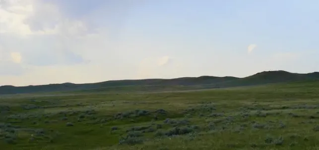
The property consists of gently sloped ground with nice views of the hills in the area. The land is covered with grass and some sagebrush. There is a small seasonal wash on property that flows the spring thaw. There is a thin two track road that runs along the northern part of the property.
The land is in a very remote area far from any utilities or services. The land is located about 5 miles south of Wilder Trail Road which is the nearest maintained road. Four-wheel drive may be needed to reach the land. This is a very large piece of land. The land measures 1/4 mile by 1/4 mile. The perimeter of the property is about 1 mile around!
More Information:
Size: 40 ACRES
Dimensions: Approximately 1320 feet by 1320 feet.
Vegetation: Grasses and sagebrush.
Views: Views of the hills, open land, no development for miles.
Topography: Rolling hills to flat.
Elevation: Approximately 2900 feet
Taxes: $181 in 2024.
Parcel Number: 08-2920-05-4-03-01-0000
Mineral Rights: Seller to reserve 1/2 of any existing mineral/oil/gas rights.
Utilities: There are no utilities near the property.
Seller Financing: Available with 50% Down Payment.
Disclaimer: This property is being sold "As-is Where-is." Buyers should perform their own due-diligence and work with the county to determine what can and can not be built, as well as what is required if applicable to bring utilities to the property. All information shown herein was obtained through sources deemed reliable but without any guarantees.
From elevation to risk assessment
Search for detailed parcel information including; Elevation & Vegetation Maps, Ownership Information, Detailed Parcel Information, Crop History Map, Soil Survey Productivity Data, and more.
Research Parcel InformationDirections
GPS: 47.43264, -108.55764
Corners of Property:
NW 47.43444, -108.56031
NE: 47.43444, -108.55499
SW: 47.43084, -108.56031
SE: 47.43084, -108.55496
Resources
Land for Sale by Phil Fogliani
Fergus County Properties By Type
- Ranches for Sale in Fergus County, Montana
- Farms for Sale in Fergus County, Montana
- Hunting Land for Sale in Fergus County, Montana
- Commercial Property for Sale in Fergus County, Montana
- Undeveloped Land for Sale in Fergus County, Montana
- Residential Property for Sale in Fergus County, Montana
- Riverfront Property for Sale in Fergus County, Montana
- Horse Property for Sale in Fergus County, Montana
- Lakefront Property for Sale in Fergus County, Montana
- Recreational Property for Sale in Fergus County, Montana
- Timberland for Sale in Fergus County, Montana
- Beachfront Property for Sale in Fergus County, Montana
Properties for Sale Nearby Counties
- Blaine County, Montana Land for Sale
- Chouteau County, Montana Land for Sale
- Golden Valley County, Montana Land for Sale
- Judith Basin County, Montana Land for Sale
- Musselshell County, Montana Land for Sale
- Petroleum County, Montana Land for Sale
- Phillips County, Montana Land for Sale
- Wheatland County, Montana Land for Sale
Fergus County Properties By City
- Coffee Creek, Montana Land for Sale
- Denton, Montana Land for Sale
- Forest Grove, Montana Land for Sale
- Grass Range, Montana Land for Sale
- Hilger, Montana Land for Sale
- Lewistown, Montana Land for Sale
- Moore, Montana Land for Sale
- Roy, Montana Land for Sale
- Winifred, Montana Land for Sale
- Heath, Montana Land for Sale
- Straw, Montana Land for Sale
- Amherst, Montana Land for Sale
- More
- Ayers Ranch Colony, Montana Land for Sale
- Baxter, Montana Land for Sale
- Becket, Montana Land for Sale
- Bell Ranch Colony, Montana Land for Sale
- Brooks, Montana Land for Sale
- Christina, Montana Land for Sale
- Cottonwood, Montana Land for Sale
- Danvers, Montana Land for Sale
- Deerfield Colony, Montana Land for Sale
- Eddies Corner, Montana Land for Sale
- Fergus, Montana Land for Sale
- Forestgrove, Montana Land for Sale
- Giltedge, Montana Land for Sale
- Glengarry, Montana Land for Sale
- Hanover, Montana Land for Sale
- Hoosac, Montana Land for Sale
- King Colony Ranch, Montana Land for Sale
- Kingston, Montana Land for Sale
- Lewistown Heights, Montana Land for Sale
- Lewistown Junction, Montana Land for Sale
- Maiden, Montana Land for Sale
- McClave, Montana Land for Sale
- Moulton, Montana Land for Sale
- New Year, Montana Land for Sale
- Piper, Montana Land for Sale
- Pownal, Montana Land for Sale
- Ross Fork, Montana Land for Sale
- Roy-Winifred Junction, Montana Land for Sale
- Samples Crossing, Montana Land for Sale
- Spring Creek Junction, Montana Land for Sale
- Suffolk, Montana Land for Sale
- Valentine, Montana Land for Sale
- Ware, Montana Land for Sale
- West Lewistown, Montana Land for Sale
