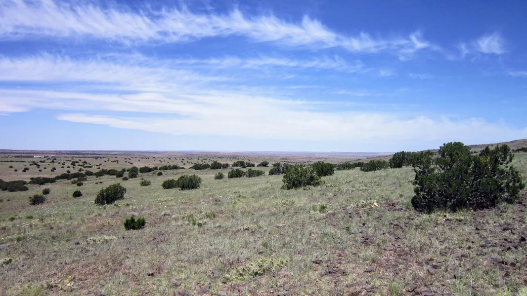
More Than 7 Acres of Incredible, Remote Land
This property, located in the Sun Meadow Ranches subdivision, is your chance to enjoy a remote piece of land in a gorgeous part of Northern Arizona. With varied terrain (mostly flat with a slight incline), natural landscapes, dirt-road access, and incredible weather year-round, the property would make an ideal place for a cabin, mobile home, RV getaway, or even your own private campsite.
You can reach the small community of Sanders, AZ in about 10 minutes. Other local towns & cities include:
Community of Chambers about 15 minutes
City of St. Johns less than an hour
City of Holbrook about an hour
The area is also known for its vast recreational opportunities for adventure including hiking, hunting, mountain biking, fishing, off-roading, and more! Nearby locations include:
Petrified Forest National Park about 30 minutes
Pueblo of Zuni about 45 minutes
Window Rock Tribal Park & Veterans Memorial about an hour
Painted Desert less than 1.5 hours
El Morro National Monument less than 1.5 hours
Apache-Sitgreaves National Forest about 2.5 hours
Priced to sell, this property offers a golden opportunity to own land in Arizona's Apache County! Contact us for more information and to make this piece of land your own.
Down Payment: $2000
Monthly Payment: varied based on term
Term Length: varies
County: Apache
Size: 7.603 Acres
Short Legal: Lot 64 Block 32 Sun Meadow Ranches
Zoning: General Agricultural: No time limit to build. No restrictions on dwelling size. You can build anything for residential purposes such as single-family, mobile, or manufactured home. Camping, RVs, and full-time RV living are okay as well.
HOA/POA: none
Terrain: both flat land, slight incline, lots of juniper trees
Elevation: 6076 ft.
Road Access: dirt road access from CR 7396
Electricity: none
Sewer: septic needed
Water: carried
Current Annual Taxes: $36.17 in 2020
Latitude: 35.1417916
Longitude: -109.3820937
Owner will carry; One member of the selling LLC is a licensed real estate agent in the state of Arizona
From elevation to risk assessment
Search for detailed parcel information including; Elevation & Vegetation Maps, Ownership Information, Detailed Parcel Information, Crop History Map, Soil Survey Productivity Data, and more.
Research Parcel InformationDirections
Driving Directions from Sanders:
Take US 191 south 2.8 miles
Turn right on Sand Sprinter Dr; follow .8 miles
Turn left on CR 7395; follow 2.2 miles
Turn right on CR 7396; follow .6 miles
Property will be on the right
Environmental Factors
Resources
Land for Sale by Jeff Fassett
Apache County Properties By Type
- Undeveloped Land for Sale in Apache County, Arizona
- Farms for Sale in Apache County, Arizona
- Residential Property for Sale in Apache County, Arizona
- Ranches for Sale in Apache County, Arizona
- Recreational Property for Sale in Apache County, Arizona
- Lakefront Property for Sale in Apache County, Arizona
- Riverfront Property for Sale in Apache County, Arizona
- Beachfront Property for Sale in Apache County, Arizona
- Timberland for Sale in Apache County, Arizona
- Hunting Land for Sale in Apache County, Arizona
- Commercial Property for Sale in Apache County, Arizona
- Horse Property for Sale in Apache County, Arizona
Properties for Sale Nearby Counties
- Catron County, Arizona Land for Sale
- Cibola County, Arizona Land for Sale
- Graham County, Arizona Land for Sale
- Greenlee County, Arizona Land for Sale
- McKinley County, Arizona Land for Sale
- Montezuma County, Arizona Land for Sale
- Navajo County, Arizona Land for Sale
- San Juan County, Arizona Land for Sale
- San Juan County, Arizona Land for Sale
Apache County Properties By City
- Alpine, Arizona Land for Sale
- Chambers, Arizona Land for Sale
- Chinle, Arizona Land for Sale
- Concho, Arizona Land for Sale
- Dennehotso, Arizona Land for Sale
- Eagar, Arizona Land for Sale
- Fort Defiance, Arizona Land for Sale
- Ganado, Arizona Land for Sale
- Greer, Arizona Land for Sale
- Houck, Arizona Land for Sale
- Lukachukai, Arizona Land for Sale
- Lupton, Arizona Land for Sale
- More
- Many Farms, Arizona Land for Sale
- Mcnary, Arizona Land for Sale
- Nazlini, Arizona Land for Sale
- Nutrioso, Arizona Land for Sale
- Rock Point, Arizona Land for Sale
- Round Rock, Arizona Land for Sale
- Saint Johns, Arizona Land for Sale
- Saint Michaels, Arizona Land for Sale
- Sanders, Arizona Land for Sale
- Springerville, Arizona Land for Sale
- Teec Nos Pos, Arizona Land for Sale
- Vernon, Arizona Land for Sale
- Window Rock, Arizona Land for Sale
- Concho Valley, Arizona Land for Sale
- Cornfields, Arizona Land for Sale
- Greasewood, Arizona Land for Sale
- Klagetoh, Arizona Land for Sale
- Mexican Water, Arizona Land for Sale
- Red Mesa, Arizona Land for Sale
- Richville, Arizona Land for Sale
- Rough Rock, Arizona Land for Sale
- Salado, Arizona Land for Sale
- Salina, Arizona Land for Sale
- Steamboat Canyon, Arizona Land for Sale
- Sunrise Springs, Arizona Land for Sale
- Tahchee, Arizona Land for Sale
- Toyei, Arizona Land for Sale
- Adamana, Arizona Land for Sale
- Allentown, Arizona Land for Sale
- Boneyard, Arizona Land for Sale
- Bonita Trading Post, Arizona Land for Sale
- Burnside, Arizona Land for Sale
- Chetco, Arizona Land for Sale
- Correjo Crossing, Arizona Land for Sale
- Cove, Arizona Land for Sale
- Coyote Springs, Arizona Land for Sale
- Crosby Crossing, Arizona Land for Sale
- Del Muerto, Arizona Land for Sale
- Diamond Fields, Arizona Land for Sale
- El Tule, Arizona Land for Sale
- Emmanuel Mission, Arizona Land for Sale
- Feaster, Arizona Land for Sale
- Flat Rock, Arizona Land for Sale
- Green Spot, Arizona Land for Sale
- Greer Place, Arizona Land for Sale
- Hawley Lake, Arizona Land for Sale
- Heap Place, Arizona Land for Sale
- Hunt, Arizona Land for Sale
- Hunters Point, Arizona Land for Sale
- Junction Overlook, Arizona Land for Sale
- Kinlichee, Arizona Land for Sale
- Kinney Junction, Arizona Land for Sale
- Los Burros, Arizona Land for Sale
- Lower Wheatfields, Arizona Land for Sale
- Maverick, Arizona Land for Sale
- Mexican Water Trading Post, Arizona Land for Sale
- Milkwater, Arizona Land for Sale
- Navajo, Arizona Land for Sale
- Northwoods, Arizona Land for Sale
- Oak Springs, Arizona Land for Sale
- Paulcell Place, Arizona Land for Sale
- Pine Springs, Arizona Land for Sale
- Pinta, Arizona Land for Sale
- Potter Place, Arizona Land for Sale
- Rosebud, Arizona Land for Sale
- Sand Springs, Arizona Land for Sale
- Sehili, Arizona Land for Sale
- Steamboat, Arizona Land for Sale
- Tanner Springs, Arizona Land for Sale
- Tes Nez Iah, Arizona Land for Sale
- Three Forks, Arizona Land for Sale
- Totacon, Arizona Land for Sale
- Troweek, Arizona Land for Sale
- Tsintaa Yiti Ii, Arizona Land for Sale
- Twin Falls, Arizona Land for Sale
- Upper Wheatfields, Arizona Land for Sale
- Wheatfields, Arizona Land for Sale
- White Clay, Arizona Land for Sale
- Wide Ruins, Arizona Land for Sale
- Wood Springs, Arizona Land for Sale
- Woodspring Trading Post, Arizona Land for Sale
- Yazzi, Arizona Land for Sale