Escape to the Mountains! 2.35 Acres in Ridges of Rabun, GA
Description
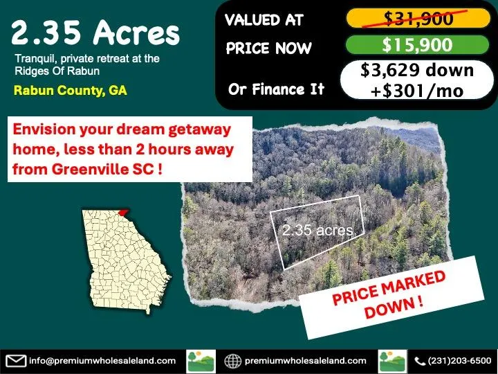
Nestled in the beautiful Ridges of Rabun Subdivision, this 2.35-acre wooded property offers the perfect opportunity for nature lovers and outdoor enthusiasts. Located just 13 minutes north of Clayton, GA, and 5 minutes from US-23, this land provides a tranquil, private retreat while still being close to town for shopping, dining, and amenities. With its slope and elevation ranging from 2360 to 2480 feet, this property is ideal for creating a mountain getaway, a custom home, or an investment in Georgia's stunning natural beauty. Rabun County, located in the northeastern part of Georgia, is known for its stunning mountain views, waterfalls, and outdoor adventures. Just minutes away from the property, you can explore the beautiful Chattahoochee National Forest, go hiking or fishing, and even visit nearby lakes. This area is a growing destination for those looking to escape the hustle and bustle of city life, with an ideal combination of seclusion and accessibility. This property is zoned R-1 for residential use, making it perfect for building your dream home or vacation cabin. Whether you are looking for a peaceful retreat or an investment in one of Georgia's most scenic regions, this land offers endless possibilities. Dont miss out on this chance to own a piece of Rabun Countys natural charm!
Note: Official website is below where you can see a virtual tour of the property.
Property Details:
Assessor's Parcel Number: 048-223 (48223)
Property Address: Smokey Hollow Dr., Rabun Gap, GA, 30568
County, State: Rabun County, GA
Subdivision: Ridges Of Rabun
Lot Number: 23
Legal Description: LOT 23 PHASE 2
Parcel Size: 2.35 acres
Terrain Type: Wooded, Steep Slope
Elevation: 2360 ft - 2480 ft
Access To Property: Smokey Hollow Dr
Road Type: Paved
Zoning / Property Use Code: R-1
GPS Coordinates (Center): 34.9668, -83.3607
GPS Coordinates (4 corners):
34.9672, -83.3602 NE
34.9664, -83.3600 SE
34.9663, -83.3612 SW
34.9669, -83.3614 NW 1
34.9670, -83.3613 NW 2
From elevation to risk assessment
Search for detailed parcel information including; Elevation & Vegetation Maps, Ownership Information, Detailed Parcel Information, Crop History Map, Soil Survey Productivity Data, and more.
Research Parcel InformationDirections
Property Directions (from the center of Clayton, GA):
Head north on S Main St toward E Savannah St (72 ft)
Follow US-23 N/US-441 N/Hwy 441 to Kelly's Creek Rd (5.9 mi)
Turn right at the 1st cross street onto E Savannah St (0.2 mi)
Turn left onto US-23 N/US-441 N/Hwy 441 (5.7 mi)
Turn right onto Kelly's Creek Rd (1.1 mi)
Turn right onto Mountain Ridge Dr (0.3 mi)
Turn right onto Shake Hollow Dr (0.2 mi)
Keep left to continue on Smokey Holw Dr (0.1 mi)
Turn left toward Smokey Holw Dr (348 ft)
Continue onto Smokey Holw Dr
(Destination will be on the right)
Environmental Factors
Resources
Rabun County Properties By Type
- Undeveloped Land for Sale in Rabun County, Georgia
- Residential Property for Sale in Rabun County, Georgia
- Farms for Sale in Rabun County, Georgia
- Lakefront Property for Sale in Rabun County, Georgia
- Riverfront Property for Sale in Rabun County, Georgia
- Commercial Property for Sale in Rabun County, Georgia
- Recreational Property for Sale in Rabun County, Georgia
- Ranches for Sale in Rabun County, Georgia
- Timberland for Sale in Rabun County, Georgia
- Hunting Land for Sale in Rabun County, Georgia
- Horse Property for Sale in Rabun County, Georgia
- Beachfront Property for Sale in Rabun County, Georgia
Properties for Sale Nearby Counties
Rabun County Properties By City
- Clayton, Georgia Land for Sale
- Dillard, Georgia Land for Sale
- Lakemont, Georgia Land for Sale
- Mountain City, Georgia Land for Sale
- Rabun Gap, Georgia Land for Sale
- Tallulah Falls, Georgia Land for Sale
- Tiger, Georgia Land for Sale
- Wiley, Georgia Land for Sale
- Sky Valley, Georgia Land for Sale
- Blalock, Georgia Land for Sale
- Dickerson Mill, Georgia Land for Sale
- Germany, Georgia Land for Sale
- More