Mountain View Acreage
High-Country Basecamp: Build Your Colorado Dream at 8,354 Feet
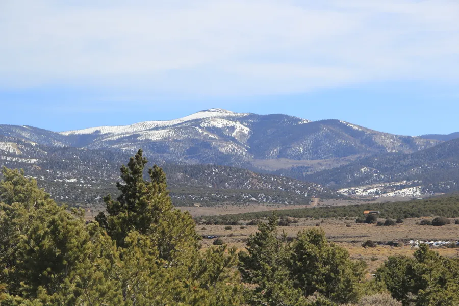
Trees, mountain views, maintained road access, mobile homes allowed: This Colorado property gives you the space and elevation to build something that's fully yours. Set on county-maintained Slegers Road in the prestigious Sangre de Cristo Ranches, it offers commanding views of Mount Blanca (Colorado's 4th highest peak) with both open buildable areas and natural tree cover for privacy.
The 5.24-acre parcel sits at 8,354 feet elevation, giving you that high-country feel with panoramic vistas of the Sangre de Cristo range and wide valley views. You've got neighbors in the subdivision, but plenty of space between properties. Whether you're thinking of a cabin, manufactured home, RV setup, or off-grid hunting basecamp, this land gives you the freedom to build your Colorado legacy without excessive restrictions.
Spend your time exploring Costilla County's legendary outdoor opportunities - from OTC elk hunting in GMU 83 to fishing at Smith Reservoir, plus easy access to Great Sand Dunes National Park (45 minutes) and endless hiking in the nearby 14ers. Whether you're building long-term or need an escape from city life, this land is ready when you are.
We are open to owner financing as well - here's what that would look like:
Total Money Down: $448 ($349 down payment + $99 doc fee)
Monthly: $248/month for 72 months
Cash Price: $12,499
100-Day Money-Back Guarantee
See info below!
Property Details:
Subdivision: Sangre de Cristo Ranches
State: CO
County: Costilla
Zip: 81133
Size: 5.24 acres
Parcel: 70236240
Legal Description: S.D.C.R. UNIT J BLK 114 LOT 1760 CONT. 5.243 AC
Approximate Lat/Long Coordinates: 37.3604 N, 105.3550 W
Elevation: 8,354 feet with panoramic mountain views
Annual Taxes: Approximately $338/year
Zoning: Estate Residential (ER)
Building & Use Options:
For a site-built home, you need a 600 sqft minimum footprint
Mobile homes are allowed (post-1976 manufactured homes)
RV/Camping: You can camp or use RVs for 14 days every 3 months (no septic required)
Temporary RV Occupancy permit available for up to 180 days with proper utilities
Contact Costilla County Zoning at (719) 672-9109 for questions
Utilities & Infrastructure:
HOA/POA: Optional Sangre de Cristo Ranches Community Association - $25/year voluntary dues
Improvements: Raw land ready for your vision
Access: County-maintained Slegers Road (year-round access)
Water: Well permit required or cistern system
Sewer: Septic system (county permit required)
Power: Solar recommended; Xcel Energy available in area
Gas: Propane delivery available locally
Recreation & Location Highlights:
Hunting: GMU Unit 83 - Over-the-counter elk tags available
Fishing: 45 minutes to Smith Reservoir & Great Sand Dunes area lakes
Hiking: 1 hour to Mount Blanca trailhead (14er climbing)
Wildlife: Regular sightings of deer, elk, bear, antelope, and various birds
Drive Times:
13 minutes to Fort Garland
45 minutes to Great Sand Dunes National Park
1 hour to Monte Vista Wildlife Refuge
1 hour 48 minutes to Pueblo
2.5 hours to Colorado Springs
3.5 hours to Denver
Why This Property Stands Out:
This isn't just raw land - it's your gateway to the high-country Colorado lifestyle. At over 8,300 feet elevation with maintained road access, you get the best of both worlds: remote mountain living with practical year-round accessibility. The Sangre de Cristo Ranches community offers minimal restrictions but maximum freedom to build your dreams.
Perfect for hunters (excellent access to elk country), outdoor enthusiasts, or anyone seeking a mountain retreat that can accommodate everything from a tiny cabin to a substantial home. The natural tree cover provides privacy while the open areas offer endless building possibilities.
Owner Financing Available - No Banks, No Credit Checks, No Hassle
Note: Information presented on this page is deemed accurate, but is not guaranteed. Buyer is advised to do their own due diligence.
From elevation to risk assessment
Search for detailed parcel information including; Elevation & Vegetation Maps, Ownership Information, Detailed Parcel Information, Crop History Map, Soil Survey Productivity Data, and more.
Research Parcel InformationDirections
Driving Directions to Property
APN: 70236240 | Slegers Rd, Fort Garland, CO 81133
From Fort Garland, CO (13 minutes):
From downtown Fort Garland, head east on 4th Avenue/US-160 E
Continue on US-160 E for approximately 2 miles
Turn LEFT (north) onto Trinchera Ranch Road N
Follow Trinchera Ranch Road N for approximately 6.7 miles
The road will continue as County Lane 6
Turn RIGHT (east) onto Slegers Road (county-maintained dirt road)
Continue on Slegers Road - property will be on your left side
Look for APN 70236240 markers or contact seller for specific landmark identification
From Alamosa, CO (1 hour):
Head south on US-160 W toward Fort Garland
Continue for approximately 45 miles to Fort Garland
In Fort Garland, continue east on US-160 E for 2 miles
Follow directions above from step 3
From Colorado Springs, CO (2.5 hours):
Take I-25 South to US-160 West (Exit 52 toward Walsenburg)
Continue on US-160 West through Walsenburg and La Veta
Continue on US-160 West for approximately 100 miles to Fort Garland
In Fort Garland, turn LEFT to continue east on US-160 E for 2 miles
Follow directions above from Fort Garland
GPS Coordinates:
Approximate Property Location: 37.3604 N, 105.3550 W
Important Notes:
Road Access: County-maintained Slegers Road provides year-round access
Road Type: Paved highways to dirt road - suitable for most vehicles
Cell Service: May be limited in the area - download offline maps recommended
Weather: Winter conditions may require 4WD or chains - check road conditions
Property Markers: Look for county parcel markers or contact seller for specific meeting point
Nearest Address: Use Fort Garland, CO for general GPS navigation, then follow detailed directions above
Landmarks Along the Route:
Fort Garland Museum (in town)
Trinchera Ranch Road (major turn)
County Lane 6 (road continues)
Slegers Road (final turn to property area)
For Additional Assistance:
Contact property seller at 435.500.6064 for:
Specific property boundary identification
Meeting arrangements for property showing
Current road conditions
Additional landmark information
Note: These directions are provided as a general guide. Road conditions and accessibility may vary seasonally. Buyers are advised to verify current road conditions and access before traveling.
Land for Sale by Collin Pettet
Costilla County Properties By Type
- Undeveloped Land for Sale in Costilla County, Colorado
- Riverfront Property for Sale in Costilla County, Colorado
- Residential Property for Sale in Costilla County, Colorado
- Lakefront Property for Sale in Costilla County, Colorado
- Ranches for Sale in Costilla County, Colorado
- Hunting Land for Sale in Costilla County, Colorado
- Recreational Property for Sale in Costilla County, Colorado
- Farms for Sale in Costilla County, Colorado
- Timberland for Sale in Costilla County, Colorado
- Horse Property for Sale in Costilla County, Colorado
- Commercial Property for Sale in Costilla County, Colorado
- Beachfront Property for Sale in Costilla County, Colorado
Properties for Sale Nearby Counties
Costilla County Properties By City
- Blanca, Colorado Land for Sale
- Chama, Colorado Land for Sale
- Fort Garland, Colorado Land for Sale
- Jaroso, Colorado Land for Sale
- San Luis, Colorado Land for Sale
- Garcia, Colorado Land for Sale
- Los Fuertes, Colorado Land for Sale
- Mesita, Colorado Land for Sale
- San Pablo, Colorado Land for Sale
- San Pedro, Colorado Land for Sale
- Eastdale, Colorado Land for Sale
- Fir, Colorado Land for Sale
- More