Montgomery 150: Tract 4
Description
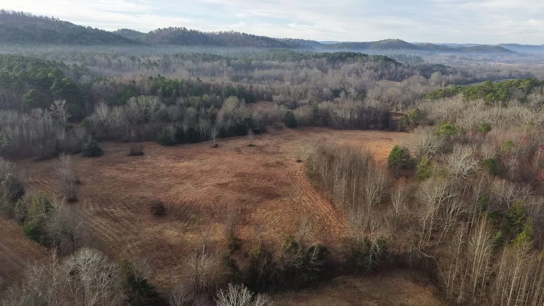
Welcome to the Montgomery 150, located near the Pine Ridge community in Montgomery County, AR. The 150 acre property consists of 13 individual tracts ranging from 5+ acres to 21+ acres. 11 of the 13 tracts have at least one boundary shared with the Ouachita National Forest. Tract #3 and #5 have two sides of forest frontage for easy access to millions of acres of public land for hunting and exploring right out your back door.
Each tract has at least one potential building site for views of the surrounding mountain range. Electricity is either in place or readily available to each tract. Multiple points of entry to each section of the subdivision will be provided for easy access to Southside Road, a paved county-maintained road.
The Montgomery 150 offers a variety of terrain for the person looking for a piece of land that is "far from ordinary." Enjoy lower lying areas for growing gardens, pasture for livestock, multiple ponds and wet weather creeks to high ridgetops for building homes/cabins to take in the views, which are in every direction you look.
This truly is an outdoor dream come true with the National Forest being feet away, access to the Ouachita River being a little over a mile away, and very light restrictions on each tract. NO HOA/POA!!
Take advantage of this rare opportunity and check out the Montgomery 150. Call Luke Alston today to experience #TheSmallTownWay!
Location:
Southside Road
Oden, AR 71961
Montgomery County
1.3 Miles S of the Ouachita River
3 Miles SE of Pine Ridge
8 Miles SW of Oden
18 Miles W of Mt Ida
22 Miles E of Mena
26 Miles W of Lake Ouachita
57 Miles W of Hot Springs
Coordinates:
34.56895, -93.87625
Property Use:
Potential Residential
Potential Second Home/Rental
Homestead
Hunting/Fishing/Recreation
Tax Information:
Parcel 001-04275-000 (00104275000): $122.96
Parcel 001-04273-000 (00104273000): $83.22
Parcel 001-04272-000 (00104272000): $15.93
Property Information:
150 Total Acres
13 Tracts
Paved County Road Frontage
Electricity Available
National Forest Boundaries on 11 of 13 Tracts
Mountain Views
Pond/Creeks
No HOA/POA
Acreage & Pricing:
Tract 1: $10k/Acre - 16.37 Acres
Tract 2: $15k/Acre - 9.86 Acres
Tract 3: $10k/Acre - 16.06 Acres
Tract 4: $12k/Acre - 12.93 Acres
Tract 5: $15k/Acre - 12.90 Acres
Tract 6: $10k/Acre - 13.93 Acres
Tract 7: $15k/Acre - 15.84 Acres
Tract 8: $8k/Acre - 21.02 Acres
Tract 9: $15k/Acre - 9.57 Acres
Tract 10: $8k/Acre - 7.50 Acres
Tract 11: $15k/Acre - 8.22 Acres
Tract 12: $15k/Acre - 5.79 Acres
Tract 13: $15k/Acre - 5.46Acres
From elevation to risk assessment
Search for detailed parcel information including; Elevation & Vegetation Maps, Ownership Information, Detailed Parcel Information, Crop History Map, Soil Survey Productivity Data, and more.
Research Parcel InformationDirections
Environmental Factors
Resources
Montgomery County Properties By Type
- Farms for Sale in Montgomery County, Arkansas
- Undeveloped Land for Sale in Montgomery County, Arkansas
- Riverfront Property for Sale in Montgomery County, Arkansas
- Ranches for Sale in Montgomery County, Arkansas
- Recreational Property for Sale in Montgomery County, Arkansas
- Residential Property for Sale in Montgomery County, Arkansas
- Lakefront Property for Sale in Montgomery County, Arkansas
- Timberland for Sale in Montgomery County, Arkansas
- Hunting Land for Sale in Montgomery County, Arkansas
- Horse Property for Sale in Montgomery County, Arkansas
- Commercial Property for Sale in Montgomery County, Arkansas
- Beachfront Property for Sale in Montgomery County, Arkansas
Properties for Sale Nearby Counties
Montgomery County Properties By City
- Caddo Gap, Arkansas Land for Sale
- Mount Ida, Arkansas Land for Sale
- Norman, Arkansas Land for Sale
- Oden, Arkansas Land for Sale
- Pencil Bluff, Arkansas Land for Sale
- Sims, Arkansas Land for Sale
- Story, Arkansas Land for Sale
- Gibbs, Arkansas Land for Sale
- Hopper, Arkansas Land for Sale
- Huddleston, Arkansas Land for Sale
- Manfred, Arkansas Land for Sale
- Mazarn, Arkansas Land for Sale
- More
- Pine Ridge, Arkansas Land for Sale
- Whitetown, Arkansas Land for Sale
- Alamo, Arkansas Land for Sale
- Albert, Arkansas Land for Sale
- Alf, Arkansas Land for Sale
- Black Springs, Arkansas Land for Sale
- Buddys Landing, Arkansas Land for Sale
- Chasewood Landing, Arkansas Land for Sale
- Cox Spring, Arkansas Land for Sale
- Fannie, Arkansas Land for Sale
- Gaston, Arkansas Land for Sale
- Hickory Station, Arkansas Land for Sale
- Hog Jaw, Arkansas Land for Sale
- Hurricane Grove, Arkansas Land for Sale
- Joplin, Arkansas Land for Sale
- Little Fir Landing, Arkansas Land for Sale
- Mauldin, Arkansas Land for Sale
- Mimosa, Arkansas Land for Sale
- Ophir, Arkansas Land for Sale
- Owley, Arkansas Land for Sale
- Plata, Arkansas Land for Sale
- Rubie, Arkansas Land for Sale
- Ruble, Arkansas Land for Sale
- Segur, Arkansas Land for Sale
- Silver, Arkansas Land for Sale
- Sweethome, Arkansas Land for Sale
- Washita, Arkansas Land for Sale
- Welsh, Arkansas Land for Sale