60 acres of World Class Bitterroot Valley Views in Stevensville, MT!
Description
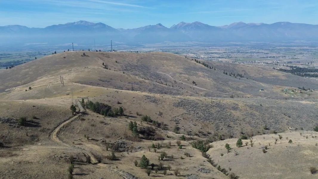
Picture this: 60 sweeping acres nestled in Montanas legendary Bitterroot Valleyrolling sagebrush hills drenched in golden light, meandering seasonal streams, and the rugged peaks of the Bitterroots as your silent backdrop. From a newly cut road carving its way across the land, youre elevated above the valley floor, offering breathtaking views in every direction and total, unfettered privacy.
Three separate recorded easements grant flexible access, so whether you arrive along a secluded driveway or choose a quiet trail through the hills, the journey is yours to map. Best of all, theres no zoning or covenants, meaning true freedombuild a rustic cabin, craft a mountaintop retreat, or preserve this wild canvas exactly as it is.
Nature takes center stage here: wildlife moves through regularlyelk, deer, sagebrush birds, even the call of distant raptorsimmersing you in Montanas untamed soul. Despite its secluded feel, towns like Stevensville, Hamilton, and even Missoula are just a short drive awayso amenities, culture, and community remain within reach.
Outdoor lovers, take note: this property places you in the heart of legendary accessworld-class fly fishing flows in the Bitterroot River below, Lost Trail Ski Area awaits each winters snow, and Idahos Lochsa and Montana wilderness trails are practically at your gateway.
Practical support? Wilco Land has partnered with local contractor Lolo Creek Excavation, ready to assist with roads, septic systems, homes, and infrastructuremaking development smoother and guided.
With annual taxes under $70, this isnt just landits a smart investment in beauty, adventure, and legacy.
PROPERTY DETAILS
Acreage: 61.23
County: Ravalli
State: Montana
Parcel ID: 13176527101110000
Google Maps: Click here
Zoning: Unzoned
Land Use / Zoning Summary: Unzoned.
Annual Taxes: $69.68
Access Notes: Use GPS coordinates to access. There is a gate code starting at the newly improved road on our property. Please contact our team to get the code for viewings.
LOCATION DETAILS
Center Coordinates: 46.510085, -113.965889
From elevation to risk assessment
Search for detailed parcel information including; Elevation & Vegetation Maps, Ownership Information, Detailed Parcel Information, Crop History Map, Soil Survey Productivity Data, and more.
Research Parcel InformationEnvironmental Factors
Resources
Ravalli County Properties By Type
- Undeveloped Land for Sale in Ravalli County, Montana
- Ranches for Sale in Ravalli County, Montana
- Riverfront Property for Sale in Ravalli County, Montana
- Residential Property for Sale in Ravalli County, Montana
- Lakefront Property for Sale in Ravalli County, Montana
- Commercial Property for Sale in Ravalli County, Montana
- Farms for Sale in Ravalli County, Montana
- Horse Property for Sale in Ravalli County, Montana
- Timberland for Sale in Ravalli County, Montana
- Recreational Property for Sale in Ravalli County, Montana
- Hunting Land for Sale in Ravalli County, Montana
- Beachfront Property for Sale in Ravalli County, Montana
Properties for Sale Nearby Counties
Ravalli County Properties By City
- Conner, Montana Land for Sale
- Corvallis, Montana Land for Sale
- Darby, Montana Land for Sale
- Florence, Montana Land for Sale
- Grantsdale, Montana Land for Sale
- Hamilton, Montana Land for Sale
- Pinesdale, Montana Land for Sale
- Stevensville, Montana Land for Sale
- Sula, Montana Land for Sale
- Victor, Montana Land for Sale
- Alta, Montana Land for Sale
- Apple Blossom Court, Montana Land for Sale
- More
- Bell Crossing, Montana Land for Sale
- Bing, Montana Land for Sale
- Bitterroot Court, Montana Land for Sale
- Bitterroot Pines, Montana Land for Sale
- Charlos Heights, Montana Land for Sale
- Cinnabar Court, Montana Land for Sale
- Cobb, Montana Land for Sale
- Como, Montana Land for Sale
- Curdys Cove, Montana Land for Sale
- Gird Point, Montana Land for Sale
- Gorus, Montana Land for Sale
- Holtet Court, Montana Land for Sale
- Kenspur, Montana Land for Sale
- Leisure Village, Montana Land for Sale
- Medicine Hot Springs, Montana Land for Sale
- Peaks and Pines Park, Montana Land for Sale
- Quast, Montana Land for Sale
- Tucker, Montana Land for Sale
- University Heights, Montana Land for Sale
- Victor Crossing, Montana Land for Sale
- Ward, Montana Land for Sale
- Woodside, Montana Land for Sale
- Woodside Crossing, Montana Land for Sale