140 Acres of Breathtaking Land for Sale in Stevensville, Montana
Description
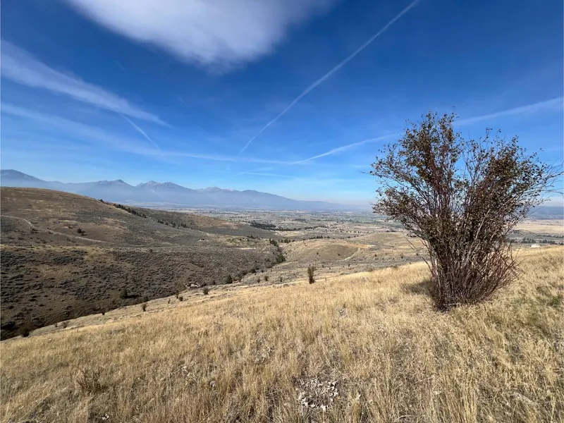
Discover your own slice of the legendary Bitterroot Valleya 140-acre sanctuary just beyond Stevensville, MT, where sweeping views and untamed landscapes unfold like a living wild invitation. Rolling hills draped in golden sagebrush, coursing seasonal streams, and open skies create a masterpiece of solitude and natural grandeur, with the ragged silhouette of the Rocky Mountains as your constant horizon.
A freshly carved road threads the length of the property, with three recorded easements offering flexible, secure accesswhether you picture stepping into a secluded cabin, planting a mountain ranch, or crafting an off-grid homestead, the groundwork is already laid.
Free from covenants, this is an artists canvas: build boldly, subdivide smartly, or preserve the silencethe choice is yours. Enjoy domestic peace just a short drive from Hamilton, Darby, and vibrant Missoulayet breathe deep the quiet of true Montana wilderness.
If adventure calls, the offering returns an echo: world-class fly-fishing on the Bitterroot River, fresh powder at Lost Trail ski area, and river runs on the Lochsa are within reach.
This tract also opens strategic opportunity: Wilco has laid the foundation for future flexibility by subdividing into 60- and 80-acre parcelsyet the full 140 acres remain available, for now, at a momentarily accessible value.
Annual taxes land around $485remarkable for such a vast footprint of Montanas frontier.
PROPERTY DETAILS
Acreage: 140.00
County: Ravalli
State: Montana
Parcel ID: 13176527101110000 and 13176527101150000
Google Maps: Click here
Zoning: Unzoned
Land Use / Zoning Summary: Unzoned.
Annual Taxes: $485.14
Access Notes: Use GPS coordinates to access. There is a gate code starting at the newly improved road on our property. Please contact our team to get the code for viewings.
LOCATION DETAILS
Center Coordinates: 46.510210, -113.969840
From elevation to risk assessment
Search for detailed parcel information including; Elevation & Vegetation Maps, Ownership Information, Detailed Parcel Information, Crop History Map, Soil Survey Productivity Data, and more.
Research Parcel InformationEnvironmental Factors
Resources
Ravalli County Properties By Type
- Undeveloped Land for Sale in Ravalli County, Montana
- Ranches for Sale in Ravalli County, Montana
- Riverfront Property for Sale in Ravalli County, Montana
- Residential Property for Sale in Ravalli County, Montana
- Lakefront Property for Sale in Ravalli County, Montana
- Commercial Property for Sale in Ravalli County, Montana
- Farms for Sale in Ravalli County, Montana
- Horse Property for Sale in Ravalli County, Montana
- Timberland for Sale in Ravalli County, Montana
- Recreational Property for Sale in Ravalli County, Montana
- Hunting Land for Sale in Ravalli County, Montana
- Beachfront Property for Sale in Ravalli County, Montana
Properties for Sale Nearby Counties
Ravalli County Properties By City
- Conner, Montana Land for Sale
- Corvallis, Montana Land for Sale
- Darby, Montana Land for Sale
- Florence, Montana Land for Sale
- Grantsdale, Montana Land for Sale
- Hamilton, Montana Land for Sale
- Pinesdale, Montana Land for Sale
- Stevensville, Montana Land for Sale
- Sula, Montana Land for Sale
- Victor, Montana Land for Sale
- Alta, Montana Land for Sale
- Apple Blossom Court, Montana Land for Sale
- More
- Bell Crossing, Montana Land for Sale
- Bing, Montana Land for Sale
- Bitterroot Court, Montana Land for Sale
- Bitterroot Pines, Montana Land for Sale
- Charlos Heights, Montana Land for Sale
- Cinnabar Court, Montana Land for Sale
- Cobb, Montana Land for Sale
- Como, Montana Land for Sale
- Curdys Cove, Montana Land for Sale
- Gird Point, Montana Land for Sale
- Gorus, Montana Land for Sale
- Holtet Court, Montana Land for Sale
- Kenspur, Montana Land for Sale
- Leisure Village, Montana Land for Sale
- Medicine Hot Springs, Montana Land for Sale
- Peaks and Pines Park, Montana Land for Sale
- Quast, Montana Land for Sale
- Tucker, Montana Land for Sale
- University Heights, Montana Land for Sale
- Victor Crossing, Montana Land for Sale
- Ward, Montana Land for Sale
- Woodside, Montana Land for Sale
- Woodside Crossing, Montana Land for Sale