2.5 Acres in NE Arizona Near Petrified Forest National Park
***See all of our listings by visiting us at governmentlandsales.us***
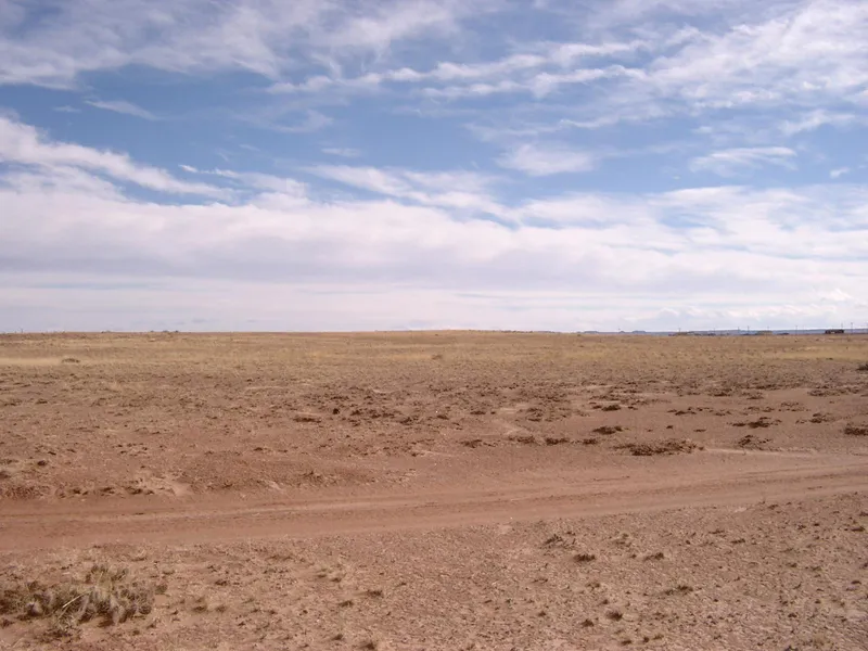
Spacious 2.5 acre lot located just south of I-40. It is undeveloped and has potential.
Sun Valley
Located just 6 miles east of Holbrook on Interstate 40 at exit 294 lies the bedroom community of Sun Valley. The area is made up of many subdivisions with varying parcel sizes, being located both north and south of the interstate. This subdivision is bordered by over 10,000 acres of state owned and BLM land. This is public land and will greatly add to your recreational opportunities and enjoyment. Aside from nearby Holbrook, you will be about an hour north of St Johns and Showlow, which is the center of the White Mountains, and 30 minutes from Snowflake. The entrance to the Petrified Forest National Park, and the Painted Desert are only minutes away.
Holbrook
World famous Route 66 rolls through the center of Holbrook, the county seat for Navajo County, Arizona. It has a population of around 5,000. You will find all services here including a restaurant for every taste. There is also plenty of lodging available.
Land Information:
Legal: Lot 3, Arizona Rancheros, Rancho 31, according to Book 4 of Plat Maps, Page 47, as recorded in the office of the County Recorder, Navajo County, Arizona.
APN: 105-24-048
Size: 2.5 Acres
Dimensions: 332.5' X 348.91'
GPS: Approximate GPS Coordinates
34.9749270, -110.0430468 (NW Corner)
34.9749336, -110.0418861 (NE Corner)
34.9740289, -110.0418754 (SE Corner)
34.9740245, -110.0436381 (SW Corner)
34.9744638, -110.0424576 (Center)
Owner financing available, please inquire. No credit checks, everyone qualifies. We accept all major credit cards. All cash offers are considered.
Document preparation fee: $299
C-2025017 ATCO
Disclaimer: All of the information in this listing is accurate to the best of our knowledge at the time of posting. Potential buyer(s) should do their own research and due diligence to verify all information provided and make a decision to purchase based on their own research.
From elevation to risk assessment
Search for detailed parcel information including; Elevation & Vegetation Maps, Ownership Information, Detailed Parcel Information, Crop History Map, Soil Survey Productivity Data, and more.
Research Parcel InformationDirections
Environmental Factors
Boise, ID
Land for Sale by Government Land Sales
Navajo County Properties By Type
- Undeveloped Land for Sale in Navajo County, Arizona
- Residential Property for Sale in Navajo County, Arizona
- Ranches for Sale in Navajo County, Arizona
- Farms for Sale in Navajo County, Arizona
- Recreational Property for Sale in Navajo County, Arizona
- Lakefront Property for Sale in Navajo County, Arizona
- Riverfront Property for Sale in Navajo County, Arizona
- Hunting Land for Sale in Navajo County, Arizona
- Horse Property for Sale in Navajo County, Arizona
- Timberland for Sale in Navajo County, Arizona
- Commercial Property for Sale in Navajo County, Arizona
- Beachfront Property for Sale in Navajo County, Arizona
Properties for Sale Nearby Counties
Navajo County Properties By City
- Blue Gap, Arizona Land for Sale
- Cibecue, Arizona Land for Sale
- Clay Springs, Arizona Land for Sale
- Fort Apache, Arizona Land for Sale
- Heber, Arizona Land for Sale
- Holbrook, Arizona Land for Sale
- Hotevilla, Arizona Land for Sale
- Indian Wells, Arizona Land for Sale
- Joseph City, Arizona Land for Sale
- Kayenta, Arizona Land for Sale
- Keams Canyon, Arizona Land for Sale
- Kykotsmovi Village, Arizona Land for Sale
- More
- Lakeside, Arizona Land for Sale
- Overgaard, Arizona Land for Sale
- Pinedale, Arizona Land for Sale
- Pinetop, Arizona Land for Sale
- Pinon, Arizona Land for Sale
- Polacca, Arizona Land for Sale
- Second Mesa, Arizona Land for Sale
- Shonto, Arizona Land for Sale
- Show Low, Arizona Land for Sale
- Snowflake, Arizona Land for Sale
- Sun Valley, Arizona Land for Sale
- Taylor, Arizona Land for Sale
- Whiteriver, Arizona Land for Sale
- Winslow, Arizona Land for Sale
- Woodruff, Arizona Land for Sale
- Dilkon, Arizona Land for Sale
- Kykotsmovi, Arizona Land for Sale
- Low Mountain, Arizona Land for Sale
- Shumway, Arizona Land for Sale
- Smoke Signal, Arizona Land for Sale
- Aponi-vi, Arizona Land for Sale
- Aripine, Arizona Land for Sale
- Arntz, Arizona Land for Sale
- Baby Rocks, Arizona Land for Sale
- Bacavi, Arizona Land for Sale
- Bell, Arizona Land for Sale
- Betatakin Overlook, Arizona Land for Sale
- Bidahochi, Arizona Land for Sale
- Burton, Arizona Land for Sale
- Bushman Acres, Arizona Land for Sale
- Carrizo, Arizona Land for Sale
- Castle Butte, Arizona Land for Sale
- Cedar Springs, Arizona Land for Sale
- Chakpahu, Arizona Land for Sale
- Chilchinbito, Arizona Land for Sale
- Cibecue Creek, Arizona Land for Sale
- Clearview Heights, Arizona Land for Sale
- East Fork, Arizona Land for Sale
- First Mesa, Arizona Land for Sale
- Goodwater, Arizona Land for Sale
- Grasshopper, Arizona Land for Sale
- Hano, Arizona Land for Sale
- Hard Rocks, Arizona Land for Sale
- Headquarters, Arizona Land for Sale
- Hibbard, Arizona Land for Sale
- Hotevilla-Bacavi, Arizona Land for Sale
- Huk Ovi, Arizona Land for Sale
- Indian Pine, Arizona Land for Sale
- Jeddito, Arizona Land for Sale
- Kawaika-A, Arizona Land for Sale
- Kokopnyama, Arizona Land for Sale
- Lake of the Woods, Arizona Land for Sale
- Linden, Arizona Land for Sale
- Mahtson-pi, Arizona Land for Sale
- Manila, Arizona Land for Sale
- Mishongnovi, Arizona Land for Sale
- Mumurva, Arizona Land for Sale
- Na Ah Tee, Arizona Land for Sale
- Navajo Gospel Mission, Arizona Land for Sale
- Nesuftanga, Arizona Land for Sale
- Oraibi, Arizona Land for Sale
- Penzance, Arizona Land for Sale
- Pinetop-Lakeside, Arizona Land for Sale
- Pink Arrow, Arizona Land for Sale
- Pivahn-hon-kya-pi, Arizona Land for Sale
- Robinson Trail Crossing, Arizona Land for Sale
- Rosedale Heights, Arizona Land for Sale
- Roundy Crossing, Arizona Land for Sale
- Schoens Crossing, Arizona Land for Sale
- Seba Dalkai, Arizona Land for Sale
- Sevenmile, Arizona Land for Sale
- Shongopovi, Arizona Land for Sale
- Shungopavi, Arizona Land for Sale
- Sichomovi, Arizona Land for Sale
- Silver Creek, Arizona Land for Sale
- Sipaulovi, Arizona Land for Sale
- Sponseller, Arizona Land for Sale
- Tees Toh, Arizona Land for Sale
- Tewa, Arizona Land for Sale
- Toreva, Arizona Land for Sale
- Tsegi, Arizona Land for Sale
- Twin Buttes, Arizona Land for Sale
- Ubank Place, Arizona Land for Sale
- Walpi, Arizona Land for Sale
- Wepo Village, Arizona Land for Sale
- West Winslow, Arizona Land for Sale
- White Cone, Arizona Land for Sale
- Zeniff, Arizona Land for Sale
