10 Acres Terlingua Ranch
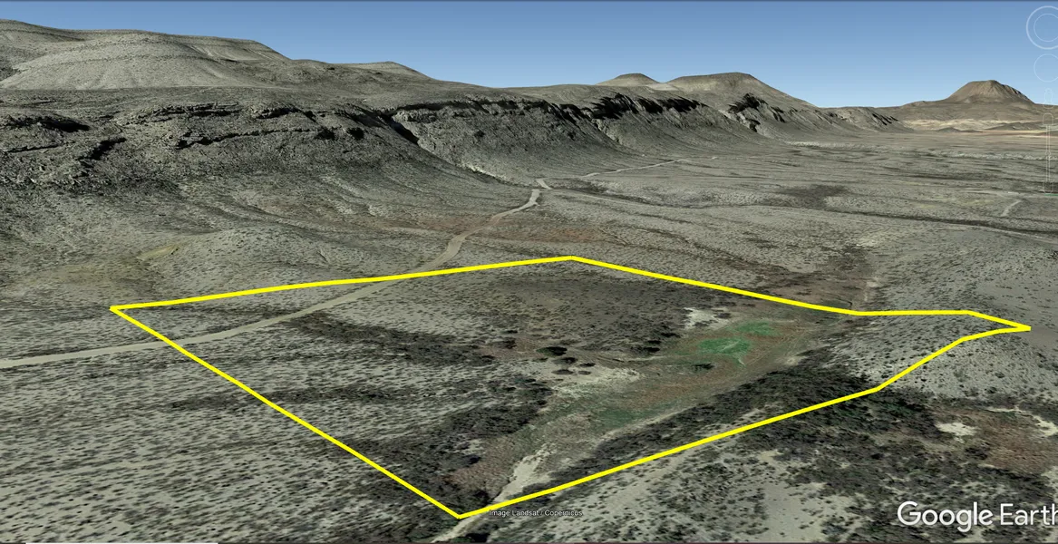
10 Acres in Terlingua Ranch in Brewster County Texas. This property has something thats extremely rare in Terlingua Ranch and that is a seasonal/rainy weather pond. Come out and enjoy the amazing mountain views, the world-famous chili cookoff, Big Bend National Park and some of the best stargazing in the country.
Zero percent owner financing offered, no credit check, and no pre-payment penalties, everyone qualifies. Just pay the doc fee and sign the contract online to get started. Monthly automated payments will start one month later.
Cash: $14,500
or
Owner Finance: $14,850 $300 doc fee/$250 down & 73 payments of $225.78 ($200 Loan Payment, $7.00 Service Fee,$15.34 POA, $3.44 property tax)
Down Payment Link:
Note: Down Payment & Doc Fee can be paid using credit or debit card. Monthly payments must be paid using ACH checking account/routing number.
Acres: 10
Property Id: 22441
Legal Description: Northwest Quarter (1/4) of the Southeast Quarter (1/4) of the Southwest Quarter (1/4) of Section (Survey) 17, Block 233, T & ST L RR Original Grantee, being 10 acres more or less.
Elevation: 3,155 ft.
Topography: Slightly sloping
Roads: Dirt Road Maintained by POATRI
Utilities: Off-Grid
Access: Dirt Road
This is off-grid land. There are no city utilities here. You can use batteries, a generator, solar panels, or a windmill for electricity.
For access to water, you can bring it with you, drill a well, have water trucked in and delivered, or set up a rain catchment system.
At the POATRI Headquarters Our office sells non-potable water for 3 cents a gallon every day from 9 am to 3 pm. Potable water is free up to 25 gallons per week for property owners.
State: Texas
County: Brewster
Property Tax: $41.21
HOA/POA: POATRI dues $183 per year for road maintenance and other amenities.
Nearest Town: Alpine, TX
Google Map Link:
GPS Coordinates:
NW: 29.668352-103.319238
SW: 29.666583-103.319183
SE: 29.666635-103.317089
NE: 29.668405-103.317148
From elevation to risk assessment
Search for detailed parcel information including; Elevation & Vegetation Maps, Ownership Information, Detailed Parcel Information, Crop History Map, Soil Survey Productivity Data, and more.
Research Parcel InformationResources
Land for Sale by Billy Rogers
Brewster County Properties By Type
- Ranches for Sale in Brewster County, Texas
- Undeveloped Land for Sale in Brewster County, Texas
- Residential Property for Sale in Brewster County, Texas
- Hunting Land for Sale in Brewster County, Texas
- Commercial Property for Sale in Brewster County, Texas
- Riverfront Property for Sale in Brewster County, Texas
- Recreational Property for Sale in Brewster County, Texas
- Farms for Sale in Brewster County, Texas
- Lakefront Property for Sale in Brewster County, Texas
- Horse Property for Sale in Brewster County, Texas
- Timberland for Sale in Brewster County, Texas
- Beachfront Property for Sale in Brewster County, Texas
Properties for Sale Nearby Counties
Brewster County Properties By City
- Alpine, Texas Land for Sale
- Marathon, Texas Land for Sale
- Terlingua, Texas Land for Sale
- Lajitas, Texas Land for Sale
- Stuart Place, Texas Land for Sale
- Altuda, Texas Land for Sale
- Ansley Place, Texas Land for Sale
- Basin Junction, Texas Land for Sale
- Beatty Place, Texas Land for Sale
- Boquillas Crossing, Texas Land for Sale
- Buenos Aires, Texas Land for Sale
- Casa de Piedra, Texas Land for Sale
- More
- Castolon, Texas Land for Sale
- Causey Place, Texas Land for Sale
- Comptons, Texas Land for Sale
- Edwards Place, Texas Land for Sale
- Haymond, Texas Land for Sale
- Hot Springs, Texas Land for Sale
- Hovey, Texas Land for Sale
- Kriebaum Place, Texas Land for Sale
- Lenox, Texas Land for Sale
- Louis Granger Place, Texas Land for Sale
- Loy Place, Texas Land for Sale
- Lunas, Texas Land for Sale
- Matthews Place, Texas Land for Sale
- McFarland Place, Texas Land for Sale
- McKinney Springs, Texas Land for Sale
- Millers, Texas Land for Sale
- Mitchell Place, Texas Land for Sale
- Old Beekley Place, Texas Land for Sale
- Old Corbett Place, Texas Land for Sale
- Old Edith Lochausen Place, Texas Land for Sale
- Old Oscar Nance Place, Texas Land for Sale
- Old Parker Place, Texas Land for Sale
- Old Reed Place, Texas Land for Sale
- Onion Spring, Texas Land for Sale
- Pantera, Texas Land for Sale
- Panther Junction, Texas Land for Sale
- Pettits, Texas Land for Sale
- Rio Grande Village, Texas Land for Sale
- Rooneys Place, Texas Land for Sale
- Rosenfeld, Texas Land for Sale
- San Francisco, Texas Land for Sale
- Shoemaker Place, Texas Land for Sale
- Sid Place, Texas Land for Sale
- Sierra Chino, Texas Land for Sale
- Solis Landing, Texas Land for Sale
- Study Butte, Texas Land for Sale
- Talley, Texas Land for Sale
- Terlingua Abaja, Texas Land for Sale
- Tesnus, Texas Land for Sale
- Titley, Texas Land for Sale
- Toronto, Texas Land for Sale
- Tres Papalotes, Texas Land for Sale
- Walker Place, Texas Land for Sale
- Woodsons, Texas Land for Sale
- Youngblood Place, Texas Land for Sale