RVs/Camping Allowed on this .44 Acre Lot Near Tierra Amarilla, NM
Year round camping and RVing allowed on this nicely wooded lot. On the other hand, it would make a great location for a cabin or tiny home. There are no HOA dues and very little restrictions with no minimum lot size to build. Electricity is nearby which buyer should verify distance before committing to any building plans.
The property is roughly a 20 minute drive to Tierra Amarilla, Ensenada, Brazos, and Los Ojos. Heron Lake is 30 minutes away while El Vado Reservoir is 37 minutes.
There are fantastic views in the Brazos Lodge Estates Subdivision which you will be sure to see when going to visit the property.
To learn more about the area and subdivision, visit ubpoa.org
County: Rio Arriba
City: Tierra Amarilla
State: New Mexico
Zip: 87575
APN: R005129
Acreage: .44 Acres
Price: $5,900
Property Type: Residential escape
Zoning: Residential
Terrain: Hilly, winding roads
Elevation: 8,210
Best Attribute: Location
Legal Description: Subdivision: Brazos Lodge Estates Lot 41, Unit 6,
Power: In the area, buyer verify
Phone: Alternative
Water: In the area, buyer verify
Sewer: Alternative
Roads: Paved
Time to Build: None
Title Information: Clear title
Annual Property Taxes (approx.): $82.24
HOA/ Misc Fees: None
GPS Coordinates: 36.747132431696, -106.438761596991
Copy and paste the above set of coordinates into the search engine of choice or your smartphone map app. This will show you the exact location of the property and how to navigate to it.
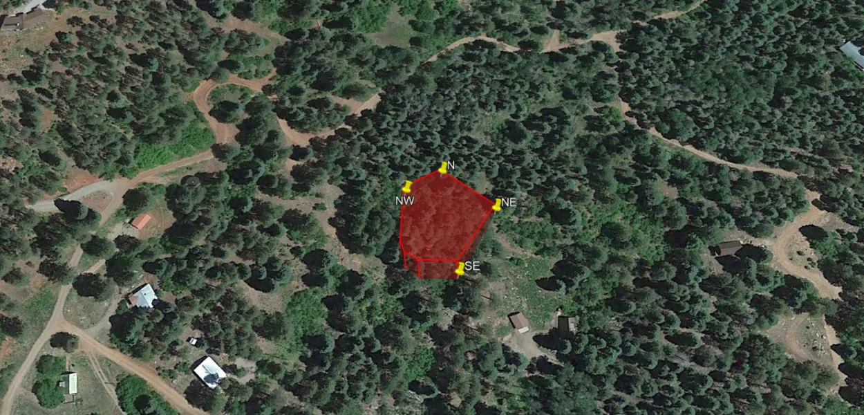
Property Corner Points (refer to reference picture):
NE 36.747099, -106.438803
SE 36.746799, -106.438998
NW 36.747204, -106.439301
N 36.747302, -106.439100
Document Fee: $100 (covers everything needed to get the property into your name). If buyer chooses to close through title, they are responsible for all closing and title fees.
Terms: Cash only
From elevation to risk assessment
Search for detailed parcel information including; Elevation & Vegetation Maps, Ownership Information, Detailed Parcel Information, Crop History Map, Soil Survey Productivity Data, and more.
Research Parcel InformationDirections
36.747132431696, -106.438761596991
Copy and paste the above set of coordinates into the search engine of choice or your smartphone map app. This will show you the exact location of the property and how to navigate to it.
Environmental Factors
Resources
Land for Sale by Christian Stahlberg
Rio Arriba County Properties By Type
- Ranches for Sale in Rio Arriba County, New Mexico
- Undeveloped Land for Sale in Rio Arriba County, New Mexico
- Residential Property for Sale in Rio Arriba County, New Mexico
- Riverfront Property for Sale in Rio Arriba County, New Mexico
- Lakefront Property for Sale in Rio Arriba County, New Mexico
- Farms for Sale in Rio Arriba County, New Mexico
- Hunting Land for Sale in Rio Arriba County, New Mexico
- Recreational Property for Sale in Rio Arriba County, New Mexico
- Timberland for Sale in Rio Arriba County, New Mexico
- Commercial Property for Sale in Rio Arriba County, New Mexico
- Horse Property for Sale in Rio Arriba County, New Mexico
- Beachfront Property for Sale in Rio Arriba County, New Mexico
Properties for Sale Nearby Counties
- Archuleta County, New Mexico Land for Sale
- Conejos County, New Mexico Land for Sale
- Los Alamos County, New Mexico Land for Sale
- Mora County, New Mexico Land for Sale
- San Juan County, New Mexico Land for Sale
- Sandoval County, New Mexico Land for Sale
- Santa Fe County, New Mexico Land for Sale
- Taos County, New Mexico Land for Sale
Rio Arriba County Properties By City
- Abiquiu, New Mexico Land for Sale
- Alcalde, New Mexico Land for Sale
- Canjilon, New Mexico Land for Sale
- Cebolla, New Mexico Land for Sale
- Chama, New Mexico Land for Sale
- Chimayo, New Mexico Land for Sale
- Cordova, New Mexico Land for Sale
- Coyote, New Mexico Land for Sale
- Dixon, New Mexico Land for Sale
- Dulce, New Mexico Land for Sale
- El Rito, New Mexico Land for Sale
- Embudo, New Mexico Land for Sale
- More
- Espanola, New Mexico Land for Sale
- Hernandez, New Mexico Land for Sale
- La Madera, New Mexico Land for Sale
- Lindrith, New Mexico Land for Sale
- Los Ojos, New Mexico Land for Sale
- Medanales, New Mexico Land for Sale
- Petaca, New Mexico Land for Sale
- San Juan Pueblo, New Mexico Land for Sale
- Tierra Amarilla, New Mexico Land for Sale
- Truchas, New Mexico Land for Sale
- Vallecitos, New Mexico Land for Sale
- Velarde, New Mexico Land for Sale
- Youngsville, New Mexico Land for Sale
- Barranca, New Mexico Land for Sale
- Brazos, New Mexico Land for Sale
- Chamita, New Mexico Land for Sale
- Chili, New Mexico Land for Sale
- Cundiyo, New Mexico Land for Sale
- El Duende, New Mexico Land for Sale
- El Llano, New Mexico Land for Sale
- El Rancho, New Mexico Land for Sale
- El Vado, New Mexico Land for Sale
- Ensenada, New Mexico Land for Sale
- Estaca, New Mexico Land for Sale
- Fairview, New Mexico Land for Sale
- Guachupangue, New Mexico Land for Sale
- Guique, New Mexico Land for Sale
- La Bolsa, New Mexico Land for Sale
- La Junta, New Mexico Land for Sale
- La Mesilla, New Mexico Land for Sale
- La Puebla, New Mexico Land for Sale
- La Puente, New Mexico Land for Sale
- Las Placitas, New Mexico Land for Sale
- Las Tablas, New Mexico Land for Sale
- Lumberton, New Mexico Land for Sale
- Ojito, New Mexico Land for Sale
- Pajarito, New Mexico Land for Sale
- Pueblito, New Mexico Land for Sale
- Rio Chiquito, New Mexico Land for Sale
- Riverside, New Mexico Land for Sale
- Rutheron, New Mexico Land for Sale
- San Pedro, New Mexico Land for Sale
- Santa Clara Pueblo, New Mexico Land for Sale
- Sombrillo, New Mexico Land for Sale
- Alire, New Mexico Land for Sale
- Amargo, New Mexico Land for Sale
- Ancones, New Mexico Land for Sale
- Apodaca, New Mexico Land for Sale
- Arroyo del Agua, New Mexico Land for Sale
- Big Horn, New Mexico Land for Sale
- Cañones, New Mexico Land for Sale
- Canova, New Mexico Land for Sale
- Carracas, New Mexico Land for Sale
- Clara Peak, New Mexico Land for Sale
- Crowther Cow Camp, New Mexico Land for Sale
- Duranes, New Mexico Land for Sale
- El Curuco, New Mexico Land for Sale
- El Guacho, New Mexico Land for Sale
- El Monte Rojo, New Mexico Land for Sale
- Frijoles Spring, New Mexico Land for Sale
- Jarosa, New Mexico Land for Sale
- La Careda, New Mexico Land for Sale
- La Chuachia, New Mexico Land for Sale
- La Cienaga, New Mexico Land for Sale
- La Cuestecita, New Mexico Land for Sale
- La Villita, New Mexico Land for Sale
- LaMadera, New Mexico Land for Sale
- Lava, New Mexico Land for Sale
- Lobato, New Mexico Land for Sale
- Los Luceros, New Mexico Land for Sale
- Los Pinos, New Mexico Land for Sale
- Lower Cañones, New Mexico Land for Sale
- Lybrook, New Mexico Land for Sale
- Lyden, New Mexico Land for Sale
- Monero, New Mexico Land for Sale
- Montecito, New Mexico Land for Sale
- Navajo City, New Mexico Land for Sale
- Plaza Blanca, New Mexico Land for Sale
- Puye, New Mexico Land for Sale
- Recheulos, New Mexico Land for Sale
- Rio Puerco, New Mexico Land for Sale
- Santo Niño, New Mexico Land for Sale
- South Petaca, New Mexico Land for Sale
- Sublette, New Mexico Land for Sale
- Tapicitoes, New Mexico Land for Sale
- Tierra Azul, New Mexico Land for Sale
- Toltec, New Mexico Land for Sale
- Vallecitos Corrales, New Mexico Land for Sale
- Willow Creek, New Mexico Land for Sale
- Wright Place, New Mexico Land for Sale
- Gallina, New Mexico Land for Sale