Rancho Lake Conchas 5.25 Acres - Corner Lot - Road Accessible
***See all of our listings by visiting us at governmentlandsales.us***
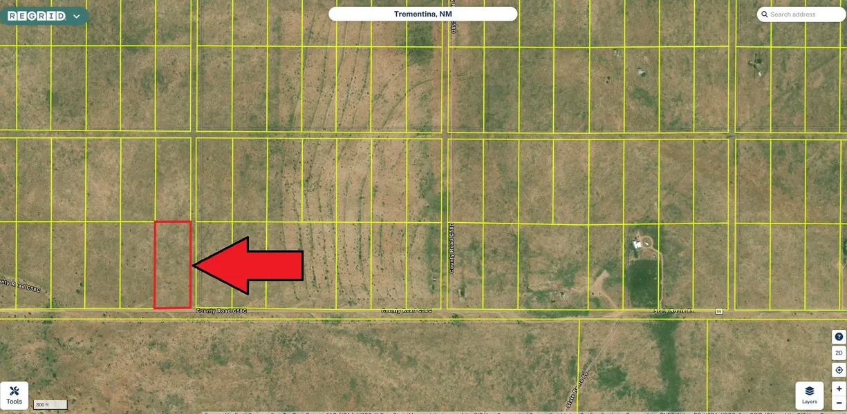
This remote corner lot is located in the Ranchos Lake Conchas Subdivision west of HWY 104 between Las Vegas and Tucumcari. There are roads in place for you to be able to drive right to the lot. There are no restrictions so you may use as you see fit.
Ranchos Lake Conchas Subdivision
There are no subdivision restrictions such as an HOA or POA, mobiles are allowed. The only restrictions are county and state regulations. Each property is a minimum of five acres and has legally platted access easements. There is no requirement to build. You can build if/when you want to. You can RV/camp on your property for up to 180 days per year. You should notify the planning and zoning department of your stays so that they know that you are not a squatter. Property zoning is A-2. Contact the planning and zoning department at 505-454-1074 with any questions about property usage.
General Area
The Rancho Lake Conchas subdivision is located southwest of Conchas Lake off HWY 104 in San Miguel County, New Mexico. Conchas Lake is about 30 miles northwest of Tucumcari. It features secluded coves, canyons, and sandy beaches, excellent for camping, boating, and fishing. One of New Mexicos largest lakes, you can explore the 11 miles of the Conchas River or 14 miles of the South Canadian River portions of the lake. With miles of shoreline, there is ample opportunity for hiking and birding too.
Land Information:
Legal: Rancho Lake Conchas Block 60 Lot 16
UPC: 1136043179049
ACC #: R0255200
Approximate Dimensions: 308' X 744'
Approximate Size: 5.25 Acres
GPS: Approximate GPS Coordinates
35.30553, -104.49020 (NW Corner)
35.30553, -104.48918 (NE Corner)
35.30347, -104.48918 (SE Corner)
35.30347, -104.49022 (SW Corner)
35.30451, -104.48970 (Center)
Owner financing available, please inquire. No credit checks, everyone qualifies. We accept all major credit cards. All cash offers are considered.
Document preparation fee: $299
C-2025064 BATT
Disclaimer: All of the information in this listing is accurate to the best of our knowledge at the time of posting. Potential buyer(s) should do their own research and due diligence to verify all information provided and make a decision to purchase based on their own research.
From elevation to risk assessment
Search for detailed parcel information including; Elevation & Vegetation Maps, Ownership Information, Detailed Parcel Information, Crop History Map, Soil Survey Productivity Data, and more.
Research Parcel InformationDirections
Boise, ID
Land for Sale by Government Land Sales
San Miguel County Properties By Type
- Ranches for Sale in San Miguel County, New Mexico
- Undeveloped Land for Sale in San Miguel County, New Mexico
- Hunting Land for Sale in San Miguel County, New Mexico
- Farms for Sale in San Miguel County, New Mexico
- Residential Property for Sale in San Miguel County, New Mexico
- Riverfront Property for Sale in San Miguel County, New Mexico
- Commercial Property for Sale in San Miguel County, New Mexico
- Lakefront Property for Sale in San Miguel County, New Mexico
- Recreational Property for Sale in San Miguel County, New Mexico
- Horse Property for Sale in San Miguel County, New Mexico
- Timberland for Sale in San Miguel County, New Mexico
- Beachfront Property for Sale in San Miguel County, New Mexico
Properties for Sale Nearby Counties
San Miguel County Properties By City
- Conchas Dam, New Mexico Land for Sale
- Ilfeld, New Mexico Land for Sale
- Las Vegas, New Mexico Land for Sale
- Montezuma, New Mexico Land for Sale
- Pecos, New Mexico Land for Sale
- Ribera, New Mexico Land for Sale
- Rociada, New Mexico Land for Sale
- Rowe, New Mexico Land for Sale
- San Jose, New Mexico Land for Sale
- Sapello, New Mexico Land for Sale
- Serafina, New Mexico Land for Sale
- Tererro, New Mexico Land for Sale
- More
- Trementina, New Mexico Land for Sale
- Villanueva, New Mexico Land for Sale
- Aurora, New Mexico Land for Sale
- Coruco, New Mexico Land for Sale
- Cowles, New Mexico Land for Sale
- East Pecos, New Mexico Land for Sale
- El Ancon, New Mexico Land for Sale
- El Porvenir, New Mexico Land for Sale
- Gallinas, New Mexico Land for Sale
- Gonzales Ranch, New Mexico Land for Sale
- Lagunita, New Mexico Land for Sale
- Los Pachecos, New Mexico Land for Sale
- North San Ysidro, New Mexico Land for Sale
- Romeroville, New Mexico Land for Sale
- Sena, New Mexico Land for Sale
- Soham, New Mexico Land for Sale
- South San Ysidro, New Mexico Land for Sale
- Adero Az, New Mexico Land for Sale
- Agua Zarca, New Mexico Land for Sale
- Alta Vista, New Mexico Land for Sale
- Ancon, New Mexico Land for Sale
- Apache Springs, New Mexico Land for Sale
- Arriba, New Mexico Land for Sale
- Barranco, New Mexico Land for Sale
- Bernal, New Mexico Land for Sale
- Blanchard, New Mexico Land for Sale
- Campana, New Mexico Land for Sale
- Chapelle, New Mexico Land for Sale
- Chaperito, New Mexico Land for Sale
- Conchas, New Mexico Land for Sale
- Douthit Place, New Mexico Land for Sale
- El Cerrito, New Mexico Land for Sale
- El Macho, New Mexico Land for Sale
- Emplazado, New Mexico Land for Sale
- Gabaldon, New Mexico Land for Sale
- Garanbuio, New Mexico Land for Sale
- Geronimo, New Mexico Land for Sale
- Gise, New Mexico Land for Sale
- Holy Ghost, New Mexico Land for Sale
- Hooverville, New Mexico Land for Sale
- Hot Springs, New Mexico Land for Sale
- Jack Canon Place, New Mexico Land for Sale
- Kroenigs, New Mexico Land for Sale
- La Fragua, New Mexico Land for Sale
- La Liendre, New Mexico Land for Sale
- La Manga, New Mexico Land for Sale
- Lagunas, New Mexico Land for Sale
- Las Dispensas, New Mexico Land for Sale
- Las Tusas, New Mexico Land for Sale
- Las Vegas Town, New Mexico Land for Sale
- Los Montoyas, New Mexico Land for Sale
- Los Vigiles, New Mexico Land for Sale
- Lovato, New Mexico Land for Sale
- Lower Colonias, New Mexico Land for Sale
- Lower La Posada, New Mexico Land for Sale
- Lower Pueblo, New Mexico Land for Sale
- Lucero, New Mexico Land for Sale
- Manuelitas, New Mexico Land for Sale
- Mineral Hill, New Mexico Land for Sale
- Montosa, New Mexico Land for Sale
- Myers, New Mexico Land for Sale
- New Trementina, New Mexico Land for Sale
- Ojita, New Mexico Land for Sale
- Ojitos Frios, New Mexico Land for Sale
- Onava, New Mexico Land for Sale
- Pajarita, New Mexico Land for Sale
- Park Springs, New Mexico Land for Sale
- Pendaries Village, New Mexico Land for Sale
- Rencona, New Mexico Land for Sale
- Romero, New Mexico Land for Sale
- Sabinoso, New Mexico Land for Sale
- Salitre, New Mexico Land for Sale
- San Augustin, New Mexico Land for Sale
- San Geronimo, New Mexico Land for Sale
- San Ignacio, New Mexico Land for Sale
- San Juan, New Mexico Land for Sale
- San Ramon, New Mexico Land for Sale
- Sanchez, New Mexico Land for Sale
- Sands, New Mexico Land for Sale
- Santa Ana, New Mexico Land for Sale
- Sheridan, New Mexico Land for Sale
- Tecolote, New Mexico Land for Sale
- Tecolotito, New Mexico Land for Sale
- Tres Lagunas, New Mexico Land for Sale
- Trout Springs, New Mexico Land for Sale
- Trujillo, New Mexico Land for Sale
- Upper Colonias, New Mexico Land for Sale
- Upper La Posada, New Mexico Land for Sale
- Upper Pueblo, New Mexico Land for Sale
- Upper Rociada, New Mexico Land for Sale
- Variadero, New Mexico Land for Sale
- Winsor Creek Summer Home, New Mexico Land for Sale
