Peaceful Living outside the Quiet Town of Tres Piedras
Off-Grid Living Outside the Quiet Town of Tres Piedras.
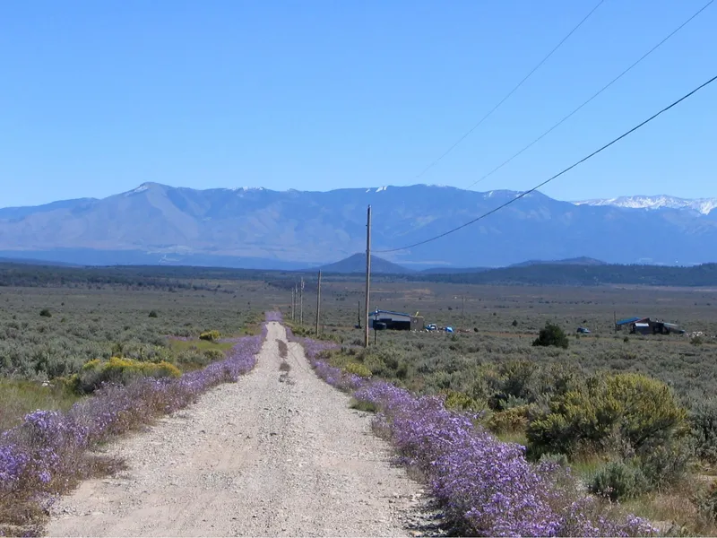
Beautiful Views in Every Direction. Tres Piedras is a small rural community located at the intersection of Highway 64 and Highway 285 in Taos County. It was settled in 1879 as a small ranching and timber village and from 1880 - 1941 it was a railroad stop. Today there is a population of around 1,000 and the town has a Post Office, Gas Station, Restaurant, Fire Department, Rangers District, a few Churches and a Public School. Ranching is very popular here and many families make a living raising livestock. The land is lightly rolling and is covered in sagebrush and scattered ponderosa pines.
PROPERTY: Tres Piedras Unit 2, Block 107, Lot I. This 0.5 acre property sits in the Southwest part of Unit 2. It has 127.95 foot Western road frontage and is 170.22 foot deep.
Power: along US 64, but not to the property yet. Solar is by far the best method for power.
Water: is deep in this area, so for now using refillable tanks or catchment would be the best methods, which is very common.
Sewage: would be by a septic system (when you build). Zoned: Agricultural / Residential / Recreational. There are very few restrictions on the property.
No association fees or dues, No time limits to build, and No requirement to make you build.
You can build a home, cabin, or mobile home or you can RV or camp on the property while visiting the area.
Taxes: less than $20 per year per lot.
FINANCING AVAILABLE! Start payments with a $294 down payment which includes a $195 document fee and puts the other $99 towards the property. We can finance the balance for as little as $78.41 per month for 4 years.
FOR MORE INFORMATION ABOUT THE AREA, THE PROPERTY OR TO PURCHASE PLEASE CLICK THE 'WEBSITE' BUTTON ON THIS PAGE.
From elevation to risk assessment
Search for detailed parcel information including; Elevation & Vegetation Maps, Ownership Information, Detailed Parcel Information, Crop History Map, Soil Survey Productivity Data, and more.
Research Parcel InformationDirections
Approximate GPS coordinates of the property corners:
Approximate GPS coordinates for the Northwest corner of the property: 3639'24.62"N, 10554'18.07"W
Approximate GPS coordinates for the Northeast corner of the property: 3639'24.62"N, 10554'15.94"W
Approximate GPS coordinates for the Southwest corner of the property: 3639'23.36"N, 10554'18.07"W
Approximate GPS coordinates for the Southeast corner of the property: 3639'23.36"N, 10554'15.94"W
Environmental Factors
Resources
Land for Sale by YourCheapLand.com
Taos County Properties By Type
- Undeveloped Land for Sale in Taos County, New Mexico
- Riverfront Property for Sale in Taos County, New Mexico
- Lakefront Property for Sale in Taos County, New Mexico
- Residential Property for Sale in Taos County, New Mexico
- Ranches for Sale in Taos County, New Mexico
- Commercial Property for Sale in Taos County, New Mexico
- Farms for Sale in Taos County, New Mexico
- Hunting Land for Sale in Taos County, New Mexico
- Recreational Property for Sale in Taos County, New Mexico
- Horse Property for Sale in Taos County, New Mexico
- Timberland for Sale in Taos County, New Mexico
- Beachfront Property for Sale in Taos County, New Mexico
Properties for Sale Nearby Counties
Taos County Properties By City
- Amalia, New Mexico Land for Sale
- Arroyo Hondo, New Mexico Land for Sale
- Arroyo Seco, New Mexico Land for Sale
- Carson, New Mexico Land for Sale
- Cerro, New Mexico Land for Sale
- Chamisal, New Mexico Land for Sale
- Costilla, New Mexico Land for Sale
- El Prado, New Mexico Land for Sale
- Llano, New Mexico Land for Sale
- Ojo Caliente, New Mexico Land for Sale
- Questa, New Mexico Land for Sale
- Ranchos De Taos, New Mexico Land for Sale
- More
- Red River, New Mexico Land for Sale
- San Cristobal, New Mexico Land for Sale
- Taos, New Mexico Land for Sale
- Taos Ski Valley, New Mexico Land for Sale
- Trampas, New Mexico Land for Sale
- Tres Piedras, New Mexico Land for Sale
- Vadito, New Mexico Land for Sale
- Valdez, New Mexico Land for Sale
- Angostura, New Mexico Land for Sale
- El Valle, New Mexico Land for Sale
- Lama, New Mexico Land for Sale
- Llano Quemado, New Mexico Land for Sale
- Ojo Sarco, New Mexico Land for Sale
- Pilar, New Mexico Land for Sale
- Pot Creek, New Mexico Land for Sale
- Ranchito, New Mexico Land for Sale
- Rio Lucio, New Mexico Land for Sale
- Rodarte, New Mexico Land for Sale
- Sunshine, New Mexico Land for Sale
- Talpa, New Mexico Land for Sale
- Taos Pueblo, New Mexico Land for Sale
- Tres Ritos, New Mexico Land for Sale
- Valle Escondido, New Mexico Land for Sale
- Cañoncito, New Mexico Land for Sale
- El Padro, New Mexico Land for Sale
- Kiowa Village, New Mexico Land for Sale
- Las Mochas, New Mexico Land for Sale
- Llano Largo, New Mexico Land for Sale
- Los Cordovas, New Mexico Land for Sale
- McGreggor Place, New Mexico Land for Sale
- Moly, New Mexico Land for Sale
- No Agua, New Mexico Land for Sale
- Peñasco, New Mexico Land for Sale
- Picuris Pueblo, New Mexico Land for Sale
- Rinconada, New Mexico Land for Sale
- Rio Pueblo, New Mexico Land for Sale
- Rock Wall, New Mexico Land for Sale
- Servilleta, New Mexico Land for Sale
- Shady Brook, New Mexico Land for Sale
- Sipapu, New Mexico Land for Sale
- Solo, New Mexico Land for Sale
- Sunshine Valley, New Mexico Land for Sale
- Taos Junction, New Mexico Land for Sale
- Twining, New Mexico Land for Sale
- Vallecito, New Mexico Land for Sale
- Ventero, New Mexico Land for Sale