West of Trinidad, 40 Acres of Wooded Land With Power
Property Details:
Internal SKU#: LA-CO-007
Size (Acres): 40
General Location: 25 min. NW of Trinidad, CO
County: Las Animas
Best Attribute: Power On Lot/Woods
Activities: Hiking, Hunting
APN or Other ID: 14019720
Legal Description: TR#:78 36-31-65 NENE- CONT-40.00 ACRS M/L and SO TRINIDAD BLK-8- LTS-12-TO-23
GPS: 37.30646, -104.614153
Property Type: Residential Vacant Land
Zoning: Commercial
Terrain: Rolling Hills
General Elevation (in feet): 6704
Power: Available On Lot Line
Phone: Mobile/Satellite/Alternative
Water: Would be by well or alternative system
Sewer: Septic or alternative system
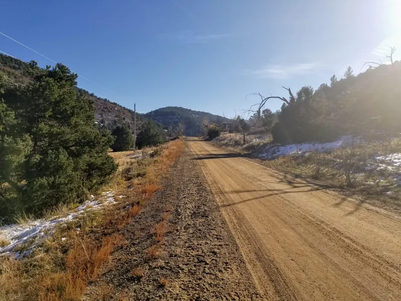
Roads: Dirt/Gravel
Time to Build: No Limit
Title Info: Clear Title
Annual Property Taxes (Approx): $10.44
Terms: Cash
Surrounding Destinations
3 h 18 min to Pike National Forest, CO
Walsenburg CO (30 min)
Gardner CO (56 min)
Lathrop State Park CO (38 min)
Spanish Peaks (1 h 10 min)
Silver Mountain (1 h 5 min)
Denver CO (3 h 9 min)
Description:
This property is located in the Ponderosa Hills subdivision, a highly valued subdivision with excellent attributes, woods, road access, and power right on the lot. This is North West of Trinidad where you will find hills, trees, and beautiful views all around. This would be an ideal location for building a home or investing in some quality Colorado land while the prices are still affordable. Youre just minutes from town where you can find shops and amenities to meet your needs.
Just 9 minutes from I-25, it is easy to travel to Pueblo, Colorado Springs, and Denver from this property. Best of all, there is power right at the lot line.
This property is in the Ponderosa Hills Subdivision.
Ponderosa Hills Ranch is a very large mountain ranch subdivision with four phases of development recorded in Las Animas County records. Some are irregular shaped 35-acre tracts while the majority of them are the typical mile square, 40-acre tracts, as is this property. Elevations are 6400-7400 feet with terrain varying from very gentle to extremely steep.
There's a nice blend of pinion, cedar, ponderosa, and Douglas fir plus some great rock out-croppings. The Ranch is located between Exits 23 and 27 of Interstate 25 approximately 9-13 miles North of Trinidad and approximately 3-4 miles West of the interstate.
The restrictions in this subdivision are lenient based on our research. You can put livestock on your property, hunt, camp, and build. Youre also permitted to install mobile or manufactured homes.
Build your own house and experience lots of enjoyable activities and beautiful places to go within this area.
Here are the GPS coordinates if you would like to look at the property using Google Maps/Earth or visit the property: 37.30646, -104.614153
From elevation to risk assessment
Search for detailed parcel information including; Elevation & Vegetation Maps, Ownership Information, Detailed Parcel Information, Crop History Map, Soil Survey Productivity Data, and more.
Research Parcel InformationLand for Sale by Luke Harris
Las Animas County Properties By Type
- Ranches for Sale in Las Animas County, Colorado
- Hunting Land for Sale in Las Animas County, Colorado
- Undeveloped Land for Sale in Las Animas County, Colorado
- Farms for Sale in Las Animas County, Colorado
- Residential Property for Sale in Las Animas County, Colorado
- Recreational Property for Sale in Las Animas County, Colorado
- Riverfront Property for Sale in Las Animas County, Colorado
- Lakefront Property for Sale in Las Animas County, Colorado
- Horse Property for Sale in Las Animas County, Colorado
- Commercial Property for Sale in Las Animas County, Colorado
- Timberland for Sale in Las Animas County, Colorado
- Beachfront Property for Sale in Las Animas County, Colorado
Properties for Sale Nearby Counties
Las Animas County Properties By City
- Aguilar, Colorado Land for Sale
- Boncarbo, Colorado Land for Sale
- Branson, Colorado Land for Sale
- Hoehne, Colorado Land for Sale
- Kim, Colorado Land for Sale
- Model, Colorado Land for Sale
- Trinchera, Colorado Land for Sale
- Trinidad, Colorado Land for Sale
- Weston, Colorado Land for Sale
- Cokedale, Colorado Land for Sale
- Delhi, Colorado Land for Sale
- El Moro, Colorado Land for Sale
- More
- Jansen, Colorado Land for Sale
- Ludlow, Colorado Land for Sale
- Monument Park, Colorado Land for Sale
- San Miguel, Colorado Land for Sale
- Segundo, Colorado Land for Sale
- Starkville, Colorado Land for Sale
- Stonewall, Colorado Land for Sale
- Tercio, Colorado Land for Sale
- Tyrone, Colorado Land for Sale
- Vigil, Colorado Land for Sale
- Villegreen, Colorado Land for Sale
- Abeyta, Colorado Land for Sale
- Andrix, Colorado Land for Sale
- Barela, Colorado Land for Sale
- Beshoar, Colorado Land for Sale
- Cordova Plaza, Colorado Land for Sale
- Earl, Colorado Land for Sale
- Engleville, Colorado Land for Sale
- Gulnare, Colorado Land for Sale
- Houghton, Colorado Land for Sale
- Lynn, Colorado Land for Sale
- Medina Plaza, Colorado Land for Sale
- Parras Plaza, Colorado Land for Sale
- Patterson Crossing, Colorado Land for Sale
- Reilly Canyon, Colorado Land for Sale
- Rugby, Colorado Land for Sale
- Sarcillo, Colorado Land for Sale
- Sequndo, Colorado Land for Sale
- Simpson, Colorado Land for Sale
- Stonewall Gap, Colorado Land for Sale
- Tijeras, Colorado Land for Sale
- Tobe, Colorado Land for Sale
- Torres, Colorado Land for Sale
- Valdez, Colorado Land for Sale
- Vallorso, Colorado Land for Sale
- Velasquez Plaza, Colorado Land for Sale
- Walts Corner, Colorado Land for Sale
- Zamara, Colorado Land for Sale