2.54 Acres Vann Ridge Rd, Westville, OK 74965
Owner financing available for all! Finance this property for as little as $400 down and $400 a month. Check our website for additional term options.
An amazing opportunity to own 2.54 Acres right next to the Illinois River. Enjoy owning land with almost no restrictions. This property is zoned residential and allows you to build the home of your dreams. Manufactured, modular, and mobile homes are also allowed.
Located conveniently 1.5 hours from Tulsa OK. The nearby city of Fayetteville AR is growing rapidly allowing you quick access to shopping. With the growth in the area, this property will continue to appreciate. Don't miss out on this exceptional opportunity, whether designing your new dream home, or looking for a weekend get away contact us today!
APN: 0480-00-001-088-0-000-00
Address: Vann Ridge Rd, Westville, OK 74965
County: Adair
State: Oklahoma
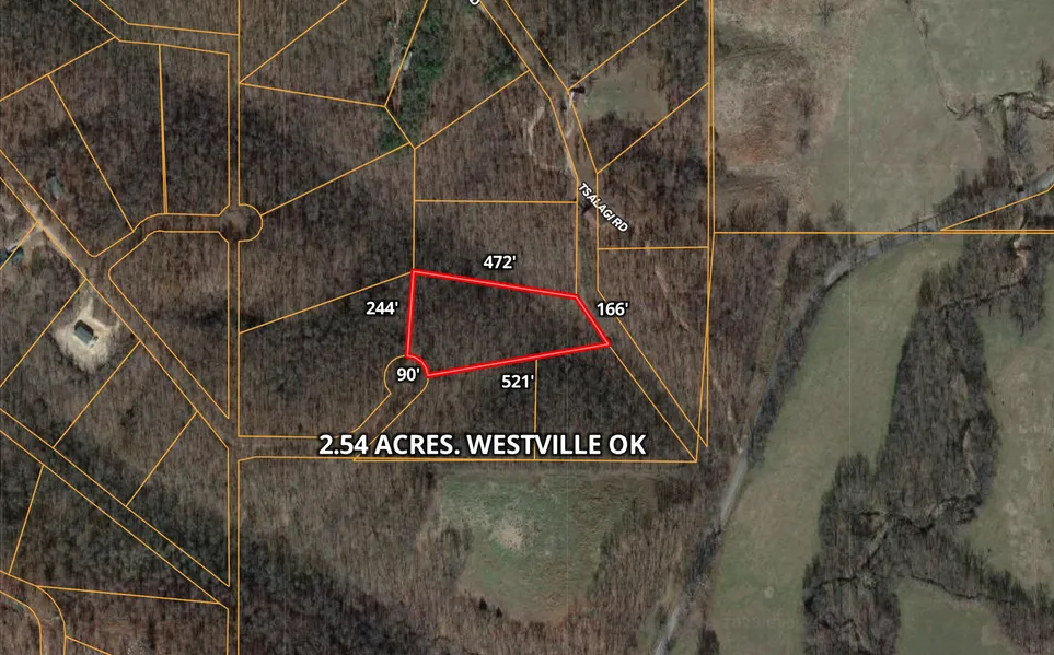
Size: 2.54 Acres
Dimensions: 90 x 244 x 472 x 166 x 521
Legal: LOT 88 1.00 Lots
Terrain: Uneven
Access: Dirt roads
Power: At the Property
Water: At the Property
Sewer: Septic Tank is Required
Taxes per Year: $24
HOA Fees per Year: $0
GPS Coordinates (center) at the road: 36.0809, -94.7777
Northwest Corner: 36.0816, -94.7778
Northeast Corner: 36.0814, -947762
Southwest Corner: 36.0808, -94.7776
Southeast Corner: 36.0811, -94.7759
Elevation: 1029
BUILDING INFORMATION
Zoning: Residential
Time Limit to Build: No time limit to build
Site Built Homes Allowed: Allowed
Modular Homes Allowed: Allowed
Manufactured Homes Allowed: Allowed
Mobile Homes Allowed: Allowed
Tiny Homes Friendly: Allowed
ALLOWABLE USES
Full-Time RV Living Allowed: Allowed
RV on the Property While you build: Allowed
Camping in a RV: Allowed
County Contact Information: Call Adair County (918) 696-7198
From elevation to risk assessment
Search for detailed parcel information including; Elevation & Vegetation Maps, Ownership Information, Detailed Parcel Information, Crop History Map, Soil Survey Productivity Data, and more.
Research Parcel InformationDirections
GPS Coordinates (center) at the road: 36.0809, -94.7777
Northwest Corner: 36.0816, -94.7778
Northeast Corner: 36.0814, -947762
Southwest Corner: 36.0808, -94.7776
Southeast Corner: 36.0811, -94.7759
Resources
Land for Sale by Bubba
Adair County Properties By Type
- Hunting Land for Sale in Adair County, Oklahoma
- Farms for Sale in Adair County, Oklahoma
- Ranches for Sale in Adair County, Oklahoma
- Undeveloped Land for Sale in Adair County, Oklahoma
- Lakefront Property for Sale in Adair County, Oklahoma
- Residential Property for Sale in Adair County, Oklahoma
- Riverfront Property for Sale in Adair County, Oklahoma
- Timberland for Sale in Adair County, Oklahoma
- Recreational Property for Sale in Adair County, Oklahoma
- Horse Property for Sale in Adair County, Oklahoma
- Commercial Property for Sale in Adair County, Oklahoma
- Beachfront Property for Sale in Adair County, Oklahoma
Properties for Sale Nearby Counties
Adair County Properties By City
- Bunch, Oklahoma Land for Sale
- Proctor, Oklahoma Land for Sale
- Stilwell, Oklahoma Land for Sale
- Watts, Oklahoma Land for Sale
- Westville, Oklahoma Land for Sale
- Salem, Oklahoma Land for Sale
- Addielee, Oklahoma Land for Sale
- Ballard, Oklahoma Land for Sale
- Baron, Oklahoma Land for Sale
- Bell, Oklahoma Land for Sale
- Blanch, Oklahoma Land for Sale
- Chance, Oklahoma Land for Sale
- More
- Cherry Tree, Oklahoma Land for Sale
- Chewey, Oklahoma Land for Sale
- Christie, Oklahoma Land for Sale
- England, Oklahoma Land for Sale
- Fairfield, Oklahoma Land for Sale
- Going Snake, Oklahoma Land for Sale
- Greasy, Oklahoma Land for Sale
- Lyons, Oklahoma Land for Sale
- Peavine, Oklahoma Land for Sale
- Piney, Oklahoma Land for Sale
- Rocky Mountain, Oklahoma Land for Sale
- Spade Mountain, Oklahoma Land for Sale
- Stony Point, Oklahoma Land for Sale
- Strawberry Spring, Oklahoma Land for Sale
- Titanic, Oklahoma Land for Sale
- Wauhillau, Oklahoma Land for Sale
- West Peavine, Oklahoma Land for Sale
- Whitmire, Oklahoma Land for Sale
- Zion, Oklahoma Land for Sale