17-Acre Lovely Subdivision or Private Estate Land, Near River
Description
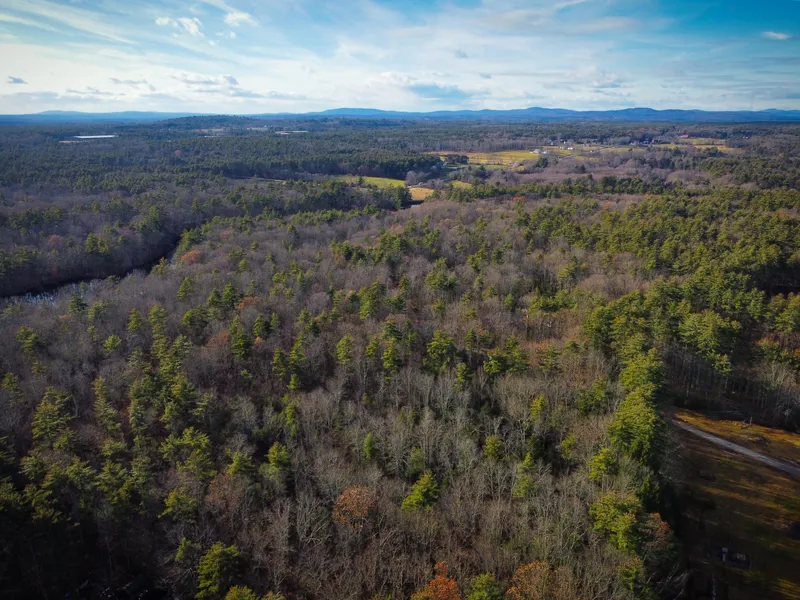
Exceptional wooded acreage in beautiful Berwick, Maine, very close to Salmon Falls River.
At more than 17 acres this could be a gorgeous private estate, but probably makes more sense as a small subdivision into 4-6 home sites to spread out road improvement costs. From the the corner of a mowed clearing, the land follows the southern side of West Meadows Lane, a private packed gravel road. The terrain is rolling but generally flat, and only moderately wooded, making it easy and pleasant to hike through. After more than 900 feet of frontage, the road changes to a paper road (little more than a rugged trail) for an additional 550+ feet.
The property is very nearly waterfront, and the paper road comes just to the edge of the Salmon Falls River (delineating the Maine / New Hampshire border), however General Electric owns a narrow strip of unused land in between.
Residents of Berwick enjoy a rural lifestyle, however attractions in Ogunquit, York, and Kittery are all less than 30 minutes away. Dover and Rochester, NH are each about 10 minutes away.
Asking Price: $168,000
Size: 17.4 acres
Address: West Meadows Lane
Town: Berwick, ME 03901
Parcel ID: Map R34 Lot 14 Sub 3
Property Tax (2024): $1795.36
Coordinates: 43.287560, -70.891685
Perc Test: Untested
Water Supply: Well needed
Survey: Survey available
RV Potential: No mobile home, trailer, or temporary dwelling unit may be used as a permanent residence. All homes must have permanent foundations.
Zoning District: R3 Rural Residential
Access: 913 feet of frontage on packed gravel private road. Additional 570 feet of frontage on paper road.
Association Dues: n/a
Terrain: Moderately wooded, rolling.
Disclosure: Listing presented by contract-holder of the parcel described. Said contract is advertised herein.
From elevation to risk assessment
Search for detailed parcel information including; Elevation & Vegetation Maps, Ownership Information, Detailed Parcel Information, Crop History Map, Soil Survey Productivity Data, and more.
Research Parcel InformationYork County Properties By Type
- Undeveloped Land for Sale in York County, Maine
- Residential Property for Sale in York County, Maine
- Farms for Sale in York County, Maine
- Ranches for Sale in York County, Maine
- Lakefront Property for Sale in York County, Maine
- Hunting Land for Sale in York County, Maine
- Commercial Property for Sale in York County, Maine
- Riverfront Property for Sale in York County, Maine
- Recreational Property for Sale in York County, Maine
- Horse Property for Sale in York County, Maine
- Timberland for Sale in York County, Maine
- Beachfront Property for Sale in York County, Maine
Properties for Sale Nearby Counties
York County Properties By City
- Acton, Maine Land for Sale
- Alfred, Maine Land for Sale
- Bar Mills, Maine Land for Sale
- Berwick, Maine Land for Sale
- Biddeford, Maine Land for Sale
- Biddeford Pool, Maine Land for Sale
- Buxton, Maine Land for Sale
- Cape Neddick, Maine Land for Sale
- Cape Porpoise, Maine Land for Sale
- Cornish, Maine Land for Sale
- East Parsonsfield, Maine Land for Sale
- East Waterboro, Maine Land for Sale
- More
- Eliot, Maine Land for Sale
- Hollis Center, Maine Land for Sale
- Kennebunk, Maine Land for Sale
- Kennebunkport, Maine Land for Sale
- Kittery, Maine Land for Sale
- Kittery Point, Maine Land for Sale
- Lebanon, Maine Land for Sale
- Limerick, Maine Land for Sale
- Limington, Maine Land for Sale
- Moody, Maine Land for Sale
- Newfield, Maine Land for Sale
- North Berwick, Maine Land for Sale
- North Waterboro, Maine Land for Sale
- Ocean Park, Maine Land for Sale
- Ogunquit, Maine Land for Sale
- Old Orchard Beach, Maine Land for Sale
- Parsonsfield, Maine Land for Sale
- Saco, Maine Land for Sale
- Sanford, Maine Land for Sale
- Shapleigh, Maine Land for Sale
- South Berwick, Maine Land for Sale
- Springvale, Maine Land for Sale
- Waterboro, Maine Land for Sale
- Wells, Maine Land for Sale
- West Kennebunk, Maine Land for Sale
- West Newfield, Maine Land for Sale
- York Beach, Maine Land for Sale
- York Harbor, Maine Land for Sale
- Arundel, Maine Land for Sale
- Dayton, Maine Land for Sale
- Kezar Falls, Maine Land for Sale
- Lyman, Maine Land for Sale
- Maplewood, Maine Land for Sale
- North Shapleigh, Maine Land for Sale
- West Buxton, Maine Land for Sale
- Adams Corner, Maine Land for Sale
- Admiralty Village, Maine Land for Sale
- Agamenticus Station, Maine Land for Sale
- Agamenticus Village, Maine Land for Sale
- Airport Village, Maine Land for Sale
- Alewife, Maine Land for Sale
- Alfred Mills, Maine Land for Sale
- Bald Head, Maine Land for Sale
- Bald Hill Crossing, Maine Land for Sale
- Bartlett Mills, Maine Land for Sale
- Bay View, Maine Land for Sale
- Beacon Corner, Maine Land for Sale
- Bedell Crossing, Maine Land for Sale
- Beech Ridge, Maine Land for Sale
- Blaisdell Corners, Maine Land for Sale
- Bonny Eagle, Maine Land for Sale
- Boothbay Park, Maine Land for Sale
- Boyd Corner, Maine Land for Sale
- Braeburn, Maine Land for Sale
- Briggs Corner, Maine Land for Sale
- Brixham, Maine Land for Sale
- Brixham Lower Corners, Maine Land for Sale
- Buffum Hill, Maine Land for Sale
- Buxton Center, Maine Land for Sale
- Camp Ellis, Maine Land for Sale
- Center Lebanon, Maine Land for Sale
- Chadbournes Mills, Maine Land for Sale
- Charles Chase Corner, Maine Land for Sale
- Chases Pond, Maine Land for Sale
- Chicopee, Maine Land for Sale
- Cider Hill, Maine Land for Sale
- Clarks Mills, Maine Land for Sale
- Clay Hill, Maine Land for Sale
- Clock Farm Corner, Maine Land for Sale
- Concordville, Maine Land for Sale
- Coopers Corner, Maine Land for Sale
- Cozy Corners, Maine Land for Sale
- Crams Corner, Maine Land for Sale
- Cummings, Maine Land for Sale
- Cutts Island, Maine Land for Sale
- Days Mill, Maine Land for Sale
- Drakes Island, Maine Land for Sale
- East Eliot, Maine Land for Sale
- East Lebanon, Maine Land for Sale
- East Limington, Maine Land for Sale
- Elms, Maine Land for Sale
- Emery Mills, Maine Land for Sale
- Emerys Bridge, Maine Land for Sale
- Emerys Corner, Maine Land for Sale
- Emory Corner, Maine Land for Sale
- Estes Hill, Maine Land for Sale
- Felch Corner, Maine Land for Sale
- Fernald Shore, Maine Land for Sale
- Ferry Beach, Maine Land for Sale
- Five Points, Maine Land for Sale
- Foristall Corners, Maine Land for Sale
- Fortunes Rocks, Maine Land for Sale
- Goodwins Mills, Maine Land for Sale
- Goose Rocks Beach, Maine Land for Sale
- Green Acre, Maine Land for Sale
- Groveville, Maine Land for Sale
- Guinea Corner, Maine Land for Sale
- High Pasture, Maine Land for Sale
- Highpine, Maine Land for Sale
- Hills Beach, Maine Land for Sale
- Hobbs Crossing, Maine Land for Sale
- Jewett, Maine Land for Sale
- Kennard Corner, Maine Land for Sale
- Kennebunk Beach, Maine Land for Sale
- Kennebunk Landing, Maine Land for Sale
- Kimbles Corner, Maine Land for Sale
- Kinney Shores, Maine Land for Sale
- Kittery Foreside, Maine Land for Sale
- Lake Arrowhead, Maine Land for Sale
- Limerick Mills, Maine Land for Sale
- Lower Landing, Maine Land for Sale
- Lower Village, Maine Land for Sale
- Mee Corners, Maine Land for Sale
- Millers Crossing, Maine Land for Sale
- Milliken Mills, Maine Land for Sale
- Moody Beach, Maine Land for Sale
- Moody Point, Maine Land for Sale
- Newtown, Maine Land for Sale
- North Alfred, Maine Land for Sale
- North Hollis, Maine Land for Sale
- North Lebanon, Maine Land for Sale
- North Limington, Maine Land for Sale
- North Parsonsfield, Maine Land for Sale
- Oak Ridge, Maine Land for Sale
- Oak Terrace, Maine Land for Sale
- Ocean View Village, Maine Land for Sale
- Oldfields, Maine Land for Sale
- Ossipee Mills, Maine Land for Sale
- Parsonage Corner, Maine Land for Sale
- Payneton, Maine Land for Sale
- Perkins Town, Maine Land for Sale
- Perrys Corner, Maine Land for Sale
- Pine Hill, Maine Land for Sale
- Pine Park, Maine Land for Sale
- Remick Corners, Maine Land for Sale
- Roberts Corner, Maine Land for Sale
- Rosemary, Maine Land for Sale
- Ross Corner, Maine Land for Sale
- Ruin Corner, Maine Land for Sale
- Salmon Falls, Maine Land for Sale
- Sandy Brook, Maine Land for Sale
- Saywards Corner, Maine Land for Sale
- Scituate, Maine Land for Sale
- Seabury, Maine Land for Sale
- Seavey Island, Maine Land for Sale
- Shady Nook, Maine Land for Sale
- Shepherds Hill, Maine Land for Sale
- South Acton, Maine Land for Sale
- South Buxton, Maine Land for Sale
- South Effingham, Maine Land for Sale
- South Eliot, Maine Land for Sale
- South Hollis, Maine Land for Sale
- South Lebanon, Maine Land for Sale
- South Limington, Maine Land for Sale
- South Parsonsfield, Maine Land for Sale
- South Sanford, Maine Land for Sale
- South Side, Maine Land for Sale
- Spang Mills, Maine Land for Sale
- Sprague City, Maine Land for Sale
- Surfside, Maine Land for Sale
- Tatnic, Maine Land for Sale
- Tattle Corner, Maine Land for Sale
- Tea Kettle Corner, Maine Land for Sale
- Tobeys Corner, Maine Land for Sale
- Tory Hill, Maine Land for Sale
- Town House Corners, Maine Land for Sale
- Turbats Creek, Maine Land for Sale
- Tylers Corner, Maine Land for Sale
- Union Falls, Maine Land for Sale
- Upper Landing, Maine Land for Sale
- Varney Crossing, Maine Land for Sale
- Waterboro Center, Maine Land for Sale
- Wells Beach, Maine Land for Sale
- Wells Beach Station, Maine Land for Sale
- Wells Branch, Maine Land for Sale
- West Hollis, Maine Land for Sale
- West Lebanon, Maine Land for Sale
- Wildes Corner, Maine Land for Sale
- Wildes District, Maine Land for Sale
- York Cliffs, Maine Land for Sale
- York Corner, Maine Land for Sale
- York Heights, Maine Land for Sale
- York Village, Maine Land for Sale