0.3 Acre Lot With a Mobile Home For Sale Next To Yellow Banks Lake!
0.3 acre rural lot with a view of the Yellow Banks Lake. The property has dirt road frontage. All utilities are available! This is zoned Residential.
This property is close to towns where you can drive for few minutes to acquire necessities. The nearest largest city is Louisville, KY and it is just over an hour drive.
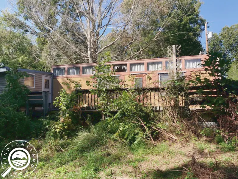
Enjoy the relaxing scenery of the lake while you sit comfortably on a chair from this parcel. There is an old
abandoned mobile home on the property.
You are welcome to visit the property. Maps, directions, and detailed payment information are all available on our website.
Purchasing Options:
Seller Financing: $20,000.00 w/ $2,000.00 down. Please see website for additional details.
Discounted Cash Price: $18,500.00
Nearby Attractions:
Angel Mounds State Historic Site: Located on the banks of the Ohio River in southwest Indiana, Angel Mounds State Historic Site is one of the best-preserved, pre-contact Native American sites in North America. Built between A.D. 1000 and 1450, the town was occupied by more than 1,000 people who were part of the Mississippian culture, and included earthen mounds built to elevate important buildings.
Friedman Park: Friedman Park is a stunning new 180-Acre park that is ideal for family picnics, corporate events, and public concerts. Amenities include an amphitheater, picnic pavilions, and biking, nature, and walking trails which provide numerous opportunities for interaction and entertainment. Visitors love the playgrounds, hiking, and fishing opportunities and appreciate the large parking area, wide open spaces, space for food trucks, and multiple public restrooms. Spend a minute on our site finding out more and come out and spend the day at the park. Open year-round from dawn to dusk.
Indian Hill Overlook Park: This location is the highest point along the Ohio River between Cincinnati, Ohio and Cairo, Illinois. This historic 17.6 acre site was once an American Indian settlement and later was the site of an estate of a prominent local family, the Schmidts.
Property Details:
NEAREST LARGE CITY: Louisville, KY - 1 hr 19 mins
STATE: Indiana (IN)
COUNTY: Warrick
ADDRESS: 12733 YELLOWBANKS TRL LOT 67N, DALE, IN, 47523
SIZE: 0.30 Acres
APN(s): 87-03-31-200-239.000-016 / 0 / 0 / 0 / 0 / 0
GPS COORDINATES: 38.21430958,-87.11975588
PROPERTY ELEVATION: 510
TAXES: No back taxes, approximately $177.88 per year total
HOA Dues: Approximately $0.00 per year total
ACCESS: Paved
ZONING: Residential
SEWER: Municipal Sewer
WATER: City Water
UTILITIES: along the road
FEMA FLOOD ZONE: No
TERRAIN: Level to sloping
CONVEYANCE: Special Warranty Deed
TITLE: Free of Liens and Encumbrances
FSL ID: IN-WAR-TS0269
Other Nearby City Distances:
Boonville, IN - 29 Minutes
Tell City, IN - 45 Minutes
Owensboro, KY - 49 Minutes
Evansville, IN - 50 Minutes
Henderson, KY - 58 Minutes
About Find Some Land Llc
Find Some Land LLC scours the country throughout the year to find the very best properties available for sale. The methods used to locate such property includes local contacts, auctions, and other investors. Tens of thousands of property records are analyzed every year in order to bring the very best to market.
Everything began several years ago while helping clients locate land to build homes in our local area. The process of locating suitable land to purchase was both time consuming and frustrating. Locating the perfect parcel at a decent price and also having adequate financing is a rare event indeed. Over the years we have been fortunate to develop the resources that allow us to do this source quality properties at fair prices and offer guaranteed seller financing.
Thank you for reviewing this property listing and please feel free to visit our website.
The Fine Print
Any property information (including, but not limited to, all real property images, descriptions, pricing, locations and availability; hereinafter referred to as Real Estate Information) made available by or through this website is provided solely for informational purposes and is not guaranteed or warranted by Find Some Land Llc. Find Some Land LLC believes the Real Estate Information to be accurate and complete; however it is subject to change and/or correction without notice.
All information regarding the real estate advertised herein has been assembled through various sources and independent investigation should be conducted by all prospective buyers. Please verify all Real Estate Information through public records available through the County Clerk or Registrar in the county where the property is located. Buyer is responsible for conducting due diligence.
If purchasing with seller financing, the contract for deed stipulates that all improvements to the property must be approved in writing. Please feel free to contact us if this is an issue for you so that we can discuss your specific situation and plans. The approval can and will be provided at the same time as the contract documents.
From elevation to risk assessment
Search for detailed parcel information including; Elevation & Vegetation Maps, Ownership Information, Detailed Parcel Information, Crop History Map, Soil Survey Productivity Data, and more.
Research Parcel InformationDirections
Driving directions can be found on the property page on the Find Some Land website. Both a Google Maps Pin and MapRight Mobile shareable link are provided.
You can also copy and paste the GPS coordinates into Google Maps and generate driving directions from any location.
Resources
Pinedale, WY
Land for Sale by FindSomeLand.com
Warrick County Properties By Type
- Undeveloped Land for Sale in Warrick County, Indiana
- Farms for Sale in Warrick County, Indiana
- Hunting Land for Sale in Warrick County, Indiana
- Lakefront Property for Sale in Warrick County, Indiana
- Timberland for Sale in Warrick County, Indiana
- Recreational Property for Sale in Warrick County, Indiana
- Residential Property for Sale in Warrick County, Indiana
- Ranches for Sale in Warrick County, Indiana
- Commercial Property for Sale in Warrick County, Indiana
- Horse Property for Sale in Warrick County, Indiana
- Beachfront Property for Sale in Warrick County, Indiana
- Riverfront Property for Sale in Warrick County, Indiana
Properties for Sale Nearby Counties
Warrick County Properties By City
- Boonville, Indiana Land for Sale
- Chandler, Indiana Land for Sale
- Elberfeld, Indiana Land for Sale
- Folsomville, Indiana Land for Sale
- Lynnville, Indiana Land for Sale
- Newburgh, Indiana Land for Sale
- Tennyson, Indiana Land for Sale
- Bullocktown, Indiana Land for Sale
- Dayville, Indiana Land for Sale
- New Hope, Indiana Land for Sale
- Paradise, Indiana Land for Sale
- Pelzer, Indiana Land for Sale
- More
- Wheatonville, Indiana Land for Sale
- Yankeetown, Indiana Land for Sale
- Ash Iron Springs, Indiana Land for Sale
- Baugh City, Indiana Land for Sale
- Camp Brosend, Indiana Land for Sale
- Castle Garden, Indiana Land for Sale
- De Gonia Springs, Indiana Land for Sale
- Dickeyville, Indiana Land for Sale
- Eames, Indiana Land for Sale
- Eby, Indiana Land for Sale
- Fisherville, Indiana Land for Sale
- Graham Valley, Indiana Land for Sale
- Hemenway, Indiana Land for Sale
- Hillcrest Terrace, Indiana Land for Sale
- Jarretts, Indiana Land for Sale
- Jockey, Indiana Land for Sale
- Loafers Station, Indiana Land for Sale
- Pyeattville, Indiana Land for Sale
- Red Bush, Indiana Land for Sale
- Rolling Acres, Indiana Land for Sale
- Rosebud, Indiana Land for Sale
- Rustic Hills, Indiana Land for Sale
- Scalesville, Indiana Land for Sale
- Stanley, Indiana Land for Sale
- Stevenson, Indiana Land for Sale
- Turpin Hill, Indiana Land for Sale
- Vanada, Indiana Land for Sale