59.55 acres in Colorado County, Texas
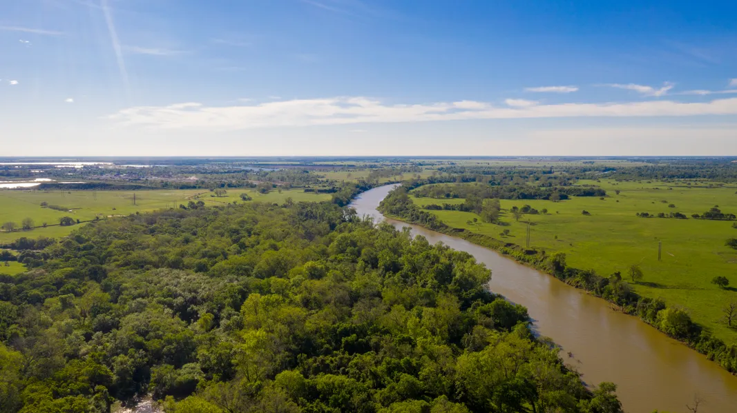
OVERVIEW The Colorado River Ranch is a phenomenal 59.547 +/- acre recreational and working property situated on the banks of the Colorado River in Eagle Lake, TX. With approximately 1,090 feet of Colorado River frontage, this property is a wildlife mecca. Known as the Goose-hunting Capital of the World, Eagle Lake has wintering waterfowl populations in the hundreds of thousands. The property sports multiple hunting blinds suited for deer, hog, predator, and varmint hunters. A long cutbank on the Colorado offers multiple positions for waterfowl blinds, while a 1.5-acre slough gives the birds an essential resting place. The sporting opportunities are endless as this property affords ample cover, water, and resting places for wildlife. The property borders Highway 90a for approximately 3,000 feet, which makes for quick access in and out. The 27.4 acres of pastureland allows the current owner to graze cows and hunt wildlife in open land. LOCATION The property is located in Eagle Lake, TX, in Colorado County. It is situated at the junction of Highway 90a and the Colorado River right next to the Altair LCRA Boat Ramp. The property is a 70-minute drive west of Houston and is only a 15-minute drive south of I-10 and Columbus. The property is situated in Rice CISD. IMPROVEMENTS The property is entirely perimeter fenced (except for Colorado River frontage) with barbed wire and is currently under a grazing lease. Cross fencing separates the pasture from the wooded areas. There are two gates to the property: one near the Altair Boat Ramp (LCRA) and one on the northeastern side near the old working pen. A 24 x 32 concrete slab, outhouse, and barbecue pit overlook the banks of the Colorado. UTILITIES A private septic system is required as the county does not provide wastewater services. The owner reports a water well behind the concrete slab, but it is not currently pumped. No well report is available. Electricity is available in the area. LAND PROFILE Approximately 27.4 acres of pastureland comprises the northeastern portion of the property. This pastureland is primarily Burleson clay and Wilson clay loam, and is suitable for intense grazing and moderate/intense cultivation. The southwestern portion of the property is heavily treed with Sycamore, Cedar Elm, Box Elder, Red Mulberry, and Pecan trees, and is made up of Norwood loam, Roetex clay, and Gholson sandy loam soils. A 1.5 +/- acre slough (great for waterfowl hunting) sits over the frequently ponded Roetex clay on the eastern boundary line. The propertys topography ranges from approximately 154 ft. to 187 ft. above sea level. ZONING & FLOOD PLAIN There is no zoning for the property as it is located in an unincorporated part of the county. The southwestern portion of the property (28.7 +/- acres) is situated in a Special Flood Hazard Area. The remainder of the property is situated in the 500-year floodplain. TAXES The entire property is currently appraised under the 1-d-1 open space agricultural valuation method, which resulted in 2019 taxes of $161.04. MINERAL RIGHTS Mineral rights will not convey with the sale of this property.
FINANCING Owner financing is available. Contact the listing agent for more details. SHOWINGS Please contact the listing agent, Lyles Carter, to schedule a showing. Buyer's agent must be identified upon first contact and present at all showings for participation in full fee structure. If these conditions are not met, fee participation will be at the sole discretion of the listing agent. DISCLAIMER The listing agent has made an effort to deliver accurate information, but buyers should independently verify any information on which they will rely in a transaction.
From elevation to risk assessment
Search for detailed parcel information including; Elevation & Vegetation Maps, Ownership Information, Detailed Parcel Information, Crop History Map, Soil Survey Productivity Data, and more.
Research Parcel InformationEnvironmental Factors
More Land for Sale in Colorado County
Colorado County Properties By Type
- Ranches for Sale in Colorado County, Texas
- Hunting Land for Sale in Colorado County, Texas
- Undeveloped Land for Sale in Colorado County, Texas
- Farms for Sale in Colorado County, Texas
- Recreational Property for Sale in Colorado County, Texas
- Residential Property for Sale in Colorado County, Texas
- Riverfront Property for Sale in Colorado County, Texas
- Horse Property for Sale in Colorado County, Texas
- Lakefront Property for Sale in Colorado County, Texas
- Commercial Property for Sale in Colorado County, Texas
- Timberland for Sale in Colorado County, Texas
- Beachfront Property for Sale in Colorado County, Texas
Properties for Sale Nearby Counties
Colorado County Properties By City
- Alleyton, Texas Land for Sale
- Altair, Texas Land for Sale
- Cat Spring, Texas Land for Sale
- Columbus, Texas Land for Sale
- Eagle Lake, Texas Land for Sale
- Garwood, Texas Land for Sale
- Glidden, Texas Land for Sale
- Nada, Texas Land for Sale
- Oakland, Texas Land for Sale
- Rock Island, Texas Land for Sale
- Sheridan, Texas Land for Sale
- Weimar, Texas Land for Sale
- More
- Borden, Texas Land for Sale
- Chesterville, Texas Land for Sale
- Elm Grove, Texas Land for Sale
- Hillcrest, Texas Land for Sale
- Osage, Texas Land for Sale
- Boedecker Junction, Texas Land for Sale
- Eldridge, Texas Land for Sale
- Frelsburg, Texas Land for Sale
- Helms, Texas Land for Sale
- Hoefer, Texas Land for Sale
- Laban, Texas Land for Sale
- Lafitte, Texas Land for Sale
- Matthews, Texas Land for Sale
- Mentz, Texas Land for Sale
- New Bielau, Texas Land for Sale
- Pisek, Texas Land for Sale
- Ramsey, Texas Land for Sale
- Rayner Junction, Texas Land for Sale
- Shaws Bend, Texas Land for Sale