Auction Information
120 acres in Klamath County, Oregon
Property 1202-132
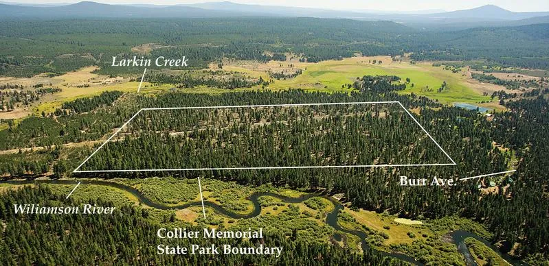
120 Acre Recreation and Timber Tract near Williamson River and State Park
Published Reserve
$59,500
Last Asking
$120,000
Size
120 Acres
Zoning
F (Forestry)
Property Inspection
At Any Time
Financing
None All Cash
Description
This 120 acre tract is located near the Williamson River and Collier Memorial State Park, ten miles north of Upper Klamath Lake, and 3.5 miles from both Chiloquin and Highway 97. The property has been selectively harvested, with wellstocked stands of residual pine remaining. There is good yearround access from Old Korral Road to the southwest corner of the tract. An easement has been provided to residences along the eastern boundary of the tract, and the property may meet the template test requirements for obtaining a home site. (Please see Supplemental Information Package for details.) The boundary of Collier Memorial State Park and Williamson River is to the west, and there are several excellent sites for a campsite or recreational vehicle. Crater Lake National Parks southern entry is a forty minute drive from the property. An overhead transmission line crosses the tract.
Location
Township 34 South, Range 7 East, west 1 / 2 of the northwest 1 / 4 of the southwest 1 / 4 of Section 11. From Klamath Falls, proceed north on Hwy. 97, turn right on to Chiloquin Highway, and proceed .9 mile to W. Chocktoot Street. Turn right and turn left on N. 1st Avenue/Sprague River Road and proceed for .7 mile. Turn left and then right onto Pine Ridge Road, and proceed for 2.4 miles (Pine Ridge becomes Old Korral), and then turn left onto Road 5811260 for one mile and left onto Burr Avenue. Proceed .7 mile to southwest corner of street.
SEALED BIDS DUE NO LATER THAN 5:00 P.M., May 16, 2012
From elevation to risk assessment
Search for detailed parcel information including; Elevation & Vegetation Maps, Ownership Information, Detailed Parcel Information, Crop History Map, Soil Survey Productivity Data, and more.
Research Parcel InformationEnvironmental Factors
Land for Sale by Colleen Cowan
Klamath County Properties By Type
- Riverfront Property for Sale in Klamath County, Oregon
- Undeveloped Land for Sale in Klamath County, Oregon
- Farms for Sale in Klamath County, Oregon
- Lakefront Property for Sale in Klamath County, Oregon
- Beachfront Property for Sale in Klamath County, Oregon
- Residential Property for Sale in Klamath County, Oregon
- Ranches for Sale in Klamath County, Oregon
- Recreational Property for Sale in Klamath County, Oregon
- Timberland for Sale in Klamath County, Oregon
- Horse Property for Sale in Klamath County, Oregon
- Commercial Property for Sale in Klamath County, Oregon
- Hunting Land for Sale in Klamath County, Oregon
Properties for Sale Nearby Counties
Klamath County Properties By City
- Beatty, Oregon Land for Sale
- Bly, Oregon Land for Sale
- Bonanza, Oregon Land for Sale
- Chemult, Oregon Land for Sale
- Chiloquin, Oregon Land for Sale
- Crescent, Oregon Land for Sale
- Dairy, Oregon Land for Sale
- Fort Klamath, Oregon Land for Sale
- Gilchrist, Oregon Land for Sale
- Keno, Oregon Land for Sale
- Klamath Falls, Oregon Land for Sale
- Malin, Oregon Land for Sale
- More
- Merrill, Oregon Land for Sale
- Midland, Oregon Land for Sale
- Sprague River, Oregon Land for Sale
- Diamond Lake, Oregon Land for Sale
- Worden, Oregon Land for Sale
- Ainsworth Corner, Oregon Land for Sale
- Algoma, Oregon Land for Sale
- Altamont, Oregon Land for Sale
- Fairhaven, Oregon Land for Sale
- Falcon Heights, Oregon Land for Sale
- Hager, Oregon Land for Sale
- Haynesville, Oregon Land for Sale
- Henley, Oregon Land for Sale
- Hildebrand, Oregon Land for Sale
- Hot Springs, Oregon Land for Sale
- Kirk, Oregon Land for Sale
- Klamath Agency, Oregon Land for Sale
- Lake of the Woods, Oregon Land for Sale
- Langell Valley, Oregon Land for Sale
- Lorella, Oregon Land for Sale
- Malone, Oregon Land for Sale
- Modoc Point, Oregon Land for Sale
- Odell Lake, Oregon Land for Sale
- Olene, Oregon Land for Sale
- Pelican City, Oregon Land for Sale
- Rocky Point, Oregon Land for Sale
- Shady Pine, Oregon Land for Sale
- Stewart Lenox, Oregon Land for Sale
- Terminal City, Oregon Land for Sale
- Yonna, Oregon Land for Sale