130 acres in Weld County, Colorado
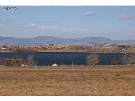
Lakeview Estates is a Prime Northern Colorado Residential Development Opportunity ~ Mountain & Water Views are incredible from this Westerly sloping land overlooking Windsor Reservoir. Potential for 200+ building sites, many with walk out basements possible. Water & sewer are stubbed at property. Perimeter fencing, early water ditch rights and irrigation pond on property. Located just minutes from Fort Collins, Loveland & Windsor. Preliminary soils, drainage & development proposals available.
About the project
WONDERFUL
MOUNTAIN
PANORAMAS!
28 Estate Lots
105 Standard Lots
70 Patio Homes
Totaling 203 new properties
Other images, Boundary Survey, Conceptual Drainage and Utilities Plans, Preliminary
Geotechnical Report, Lakeview Land Use Breakdown, and more available upon request
The proposed project is located in Weld County, and is approximately 130
acres in size. Per discussions with the Town Planner, the site is zoned
Suburban Perimeter, which could allow a mix of uses including residential and
commercial. Initial concept plans would allow approx 200-240 residential units
to be developed on this site.
The property will need to be annexed into the Town of Severance and then go
through a preliminary and final plat review process. It was indicated the
annexing and planning process would be a combined process and straight
forward but could take as long as 6-9 months to complete. This will need to
be discussed at a pre-application meeting. Development of this site is subject
to the requirements of the Town of Severance.
The Town of Severance is pro-growth for projects that meet the vision of the
Towns Comprehensive plan and meet requirements of the Town Code. The
process for projects like Lakeview Estates can be very straight forward. The
Town has a desire to be helpful and will expedite the process wherever
practical.
The Town of Severance will provide water and sewer service. Drainage design
will conform to the current Town of Severance requirements. Design of on-site
irrigation systems for the open space and lot areas will be evaluated after
completion of the land planning.
Preliminary geotechnical studies and reports, as well as topographic field and
boundary surveys have been completed. It is assumed there will only be a
simple intersection connection (similar to Fax Ridge) to CR 74; no significant
improvements will be made to CR 74.
From elevation to risk assessment
Search for detailed parcel information including; Elevation & Vegetation Maps, Ownership Information, Detailed Parcel Information, Crop History Map, Soil Survey Productivity Data, and more.
Research Parcel InformationMore Land for Sale in Weld County
Weld County Properties By Type
- Undeveloped Land for Sale in Weld County, Colorado
- Farms for Sale in Weld County, Colorado
- Ranches for Sale in Weld County, Colorado
- Commercial Property for Sale in Weld County, Colorado
- Residential Property for Sale in Weld County, Colorado
- Horse Property for Sale in Weld County, Colorado
- Hunting Land for Sale in Weld County, Colorado
- Lakefront Property for Sale in Weld County, Colorado
- Riverfront Property for Sale in Weld County, Colorado
- Recreational Property for Sale in Weld County, Colorado
- Timberland for Sale in Weld County, Colorado
- Beachfront Property for Sale in Weld County, Colorado
Properties for Sale Nearby Counties
- Adams County, Colorado Land for Sale
- Boulder County, Colorado Land for Sale
- Broomfield County, Colorado Land for Sale
- Kimball County, Colorado Land for Sale
- Laramie County, Colorado Land for Sale
- Larimer County, Colorado Land for Sale
- Logan County, Colorado Land for Sale
- Morgan County, Colorado Land for Sale
Weld County Properties By City
- Ault, Colorado Land for Sale
- Briggsdale, Colorado Land for Sale
- Carr, Colorado Land for Sale
- Dacono, Colorado Land for Sale
- Eaton, Colorado Land for Sale
- Erie, Colorado Land for Sale
- Evans, Colorado Land for Sale
- Firestone, Colorado Land for Sale
- Fort Lupton, Colorado Land for Sale
- Frederick, Colorado Land for Sale
- Galeton, Colorado Land for Sale
- Gilcrest, Colorado Land for Sale
- More
- Gill, Colorado Land for Sale
- Greeley, Colorado Land for Sale
- Grover, Colorado Land for Sale
- Hereford, Colorado Land for Sale
- Hudson, Colorado Land for Sale
- Johnstown, Colorado Land for Sale
- Keenesburg, Colorado Land for Sale
- Kersey, Colorado Land for Sale
- La Salle, Colorado Land for Sale
- Lucerne, Colorado Land for Sale
- Mead, Colorado Land for Sale
- Milliken, Colorado Land for Sale
- New Raymer, Colorado Land for Sale
- Nunn, Colorado Land for Sale
- Pierce, Colorado Land for Sale
- Platteville, Colorado Land for Sale
- Roggen, Colorado Land for Sale
- Severance, Colorado Land for Sale
- Stoneham, Colorado Land for Sale
- Windsor, Colorado Land for Sale
- Garden City, Colorado Land for Sale
- Raymer, Colorado Land for Sale
- Adna, Colorado Land for Sale
- Alden, Colorado Land for Sale
- Auburn, Colorado Land for Sale
- Avalo, Colorado Land for Sale
- Barnesville, Colorado Land for Sale
- Bracewell, Colorado Land for Sale
- Bruce, Colorado Land for Sale
- Buckingham, Colorado Land for Sale
- Buda, Colorado Land for Sale
- Bunyan, Colorado Land for Sale
- Canton, Colorado Land for Sale
- Cloverly, Colorado Land for Sale
- Comer, Colorado Land for Sale
- Cornish, Colorado Land for Sale
- Dearfield, Colorado Land for Sale
- Dent, Colorado Land for Sale
- Dick, Colorado Land for Sale
- Dover, Colorado Land for Sale
- East La Salle, Colorado Land for Sale
- Elm, Colorado Land for Sale
- Elwell, Colorado Land for Sale
- Evanston, Colorado Land for Sale
- Farmers, Colorado Land for Sale
- Fosston, Colorado Land for Sale
- Gates, Colorado Land for Sale
- Gowanda, Colorado Land for Sale
- Greeley Junction, Colorado Land for Sale
- Hambert, Colorado Land for Sale
- Hardin, Colorado Land for Sale
- Hardman, Colorado Land for Sale
- Harney, Colorado Land for Sale
- Highland Lake, Colorado Land for Sale
- Hillsboro, Colorado Land for Sale
- Houston, Colorado Land for Sale
- Hurrich, Colorado Land for Sale
- Idaho Creek, Colorado Land for Sale
- Jackson Field, Colorado Land for Sale
- Jessum, Colorado Land for Sale
- Johnson, Colorado Land for Sale
- Kahler, Colorado Land for Sale
- Keota, Colorado Land for Sale
- Kirkland, Colorado Land for Sale
- Krauss, Colorado Land for Sale
- Kuner, Colorado Land for Sale
- Lowe, Colorado Land for Sale
- Maloy, Colorado Land for Sale
- Mason Corner, Colorado Land for Sale
- Masters, Colorado Land for Sale
- Matthews, Colorado Land for Sale
- Mumper Corner, Colorado Land for Sale
- Peckham, Colorado Land for Sale
- Plumbs, Colorado Land for Sale
- Powars, Colorado Land for Sale
- Prospect Valley, Colorado Land for Sale
- Pulliam, Colorado Land for Sale
- Purcell, Colorado Land for Sale
- Puritan, Colorado Land for Sale
- Rinn, Colorado Land for Sale
- Rockport, Colorado Land for Sale
- Rosedale, Colorado Land for Sale
- Roy, Colorado Land for Sale
- Saint Vrains, Colorado Land for Sale
- Sloan, Colorado Land for Sale
- South Roggen, Colorado Land for Sale
- Spanish Village, Colorado Land for Sale
- Stage, Colorado Land for Sale
- Tampa, Colorado Land for Sale
- Tonville, Colorado Land for Sale
- Vollmar, Colorado Land for Sale
- Walker, Colorado Land for Sale
- Warren, Colorado Land for Sale
- Wattenberg, Colorado Land for Sale
- Welty, Colorado Land for Sale
- Wildcat, Colorado Land for Sale