301 Monroe Avenue Northeast, Ardmore, OK 73401 - Carter County
Unlock the Potential: 4.26 Acres Near Everything in Ardmore, OK
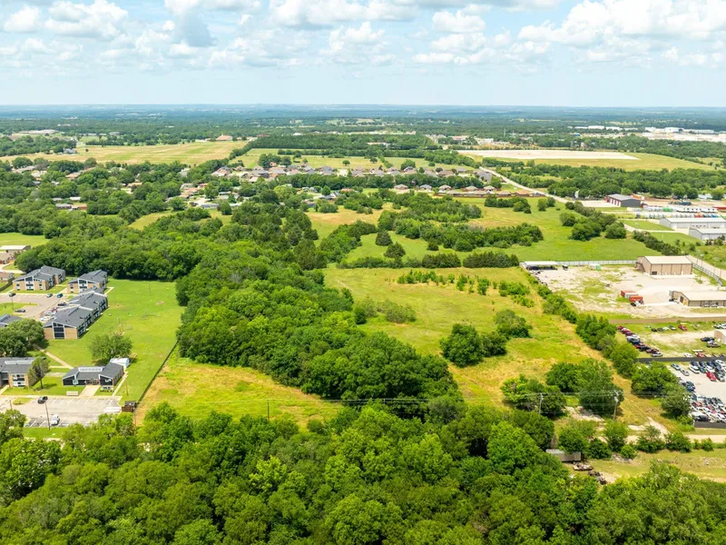
Unlock potential with this versatile 4.26-acre parcel located at the corner of Monroe Avenue and Refinery Road in Ardmore, Oklahoma. Perfectly positioned just blocks from Broadlawn Park and Will Rogers Elementary School, this property offers both convenience and promise for future development.
Whether you're envisioning a residential subdivision, or simply holding for future appreciation, the opportunity grows even larger, an adjacent 5-acre lot is also available, offering a rare chance to own over 9 contiguous acres in this established area. With easy access to the Burlington Northern Santa Fe Railway, major local roads, and less than 10 minutes to downtown Ardmore, the location supports a range of uses. Plus, it's strategically situated just 90 minutes from Oklahoma City and under 2 hours to Dallas and Fort Worth, making it an ideal hub for regional connectivity. Nearby parks, schools, and local infrastructure make this a smart choice for developers, investors, and business-minded buyers alike.
Dont miss this rare opportunity to secure a strategic piece of land in one of Ardmores most accessible and versatile locations.
Property Information
Parcel Size: 4.26 Acres
State: Oklahoma
County: Carter
Nearest Cities: Ardmore
Parcel #: 1990-20-04S-02E-3-022-00
Address: 301 Monroe Ave Ne, Ardmore, OK, 73401
Legal Description: W 5.18 Ac Se Se Sw 20 04 S 02 E & Sw Se Sw Less 5 Ac. 20 04 S 02 E Carter County, OK, APN#1990-20-04S-02E-3-022-00
Zip Code: 73401
Annual Property Taxes: $86.98
Agricultural Tax Exemption: No
HOA: No
HOA per Year: None!
Survey Available: Yes
School District: Ardmore Sch Dist (AD2)
Liens and Back Taxes: None!
Source Deed: Sent for Filing.
Title Status: Free & Clear!
Outgoing Conveyance: Warranty Deed
Property Features
Acres: 4.26
Dimension: 602 feet x 1,321 feet
County: Carter
Access: Yes
Power: Available
Water: Available
Coordinates: 34.1874, -97.1185
Zoning: Residential Multi Family
Elevation: 840 ft
Terrain: Flat
Floodplain: Yes
Duplexes: Yes
Mobiles: No
Tiny Homes: No
Barndominiums: No
RV's: No
Camping: No
Utilities:
Power: Oklahoma Gas and Electric (OG&E), Solar, wind, propane, or alternative energy source.
Water: Ardmore City Water Department, Water well, collection, hauling/delivery, or alternative.
Sewer: Septic or alternative sewer system.
Trash: City of Ardmore Sanitation Dept
Phone: Cellular, VOIP (see internet below), and satellite phone through Iridium, Globalstar, or Inmarsat.
Internet: Arbuckle Communications, Satellite internet through Starlink, HughesNet, or ViaSat.
Cable: Satellite cable through Dish or DirectTV.
County Contacts:
County Assessor: Kerry Ross (580) 223-9594
County Treasurer: Marsha Collins (580) 223-9467
County Zoning: Kelly Brawley (580) 223-8162
County CAD: Kerry Ross (580) 223-9594
County GIS: James Allen (580) 319-5986
From elevation to risk assessment
Search for detailed parcel information including; Elevation & Vegetation Maps, Ownership Information, Detailed Parcel Information, Crop History Map, Soil Survey Productivity Data, and more.
Research Parcel InformationDirections
Address to put in map on phone: 301 Monroe Avenue Northeast, Ardmore, OK, 73401
or GPS Coordinates: 34.1874, -97.1185
Resources
Land for Sale by Robert Dow
Carter County Properties By Type
- Undeveloped Land for Sale in Carter County, Oklahoma
- Residential Property for Sale in Carter County, Oklahoma
- Farms for Sale in Carter County, Oklahoma
- Ranches for Sale in Carter County, Oklahoma
- Timberland for Sale in Carter County, Oklahoma
- Lakefront Property for Sale in Carter County, Oklahoma
- Hunting Land for Sale in Carter County, Oklahoma
- Commercial Property for Sale in Carter County, Oklahoma
- Horse Property for Sale in Carter County, Oklahoma
- Riverfront Property for Sale in Carter County, Oklahoma
- Recreational Property for Sale in Carter County, Oklahoma
- Beachfront Property for Sale in Carter County, Oklahoma
Properties for Sale Nearby Counties
Carter County Properties By City
- Ardmore, Oklahoma Land for Sale
- Fox, Oklahoma Land for Sale
- Gene Autry, Oklahoma Land for Sale
- Graham, Oklahoma Land for Sale
- Healdton, Oklahoma Land for Sale
- Hennepin, Oklahoma Land for Sale
- Lone Grove, Oklahoma Land for Sale
- Ratliff City, Oklahoma Land for Sale
- Springer, Oklahoma Land for Sale
- Tatums, Oklahoma Land for Sale
- Tussy, Oklahoma Land for Sale
- Wilson, Oklahoma Land for Sale
- More
- Milo, Oklahoma Land for Sale
- Pooleville, Oklahoma Land for Sale
- Rubottom, Oklahoma Land for Sale
- Alpers, Oklahoma Land for Sale
- Baum, Oklahoma Land for Sale
- Brock, Oklahoma Land for Sale
- Caldwell Hill, Oklahoma Land for Sale
- Cheek, Oklahoma Land for Sale
- Clemscott, Oklahoma Land for Sale
- Cobalt Junction, Oklahoma Land for Sale
- Dickson, Oklahoma Land for Sale
- Dillard, Oklahoma Land for Sale
- Dundee, Oklahoma Land for Sale
- Durwood, Oklahoma Land for Sale
- Glenn, Oklahoma Land for Sale
- Hewitt, Oklahoma Land for Sale
- Newport, Oklahoma Land for Sale
- Old Scott, Oklahoma Land for Sale
- Post Oak, Oklahoma Land for Sale
- Provence, Oklahoma Land for Sale
- Pruitt City, Oklahoma Land for Sale
- Rexroat, Oklahoma Land for Sale
- Wirt, Oklahoma Land for Sale
- Woodford, Oklahoma Land for Sale
- Zaneis, Oklahoma Land for Sale
