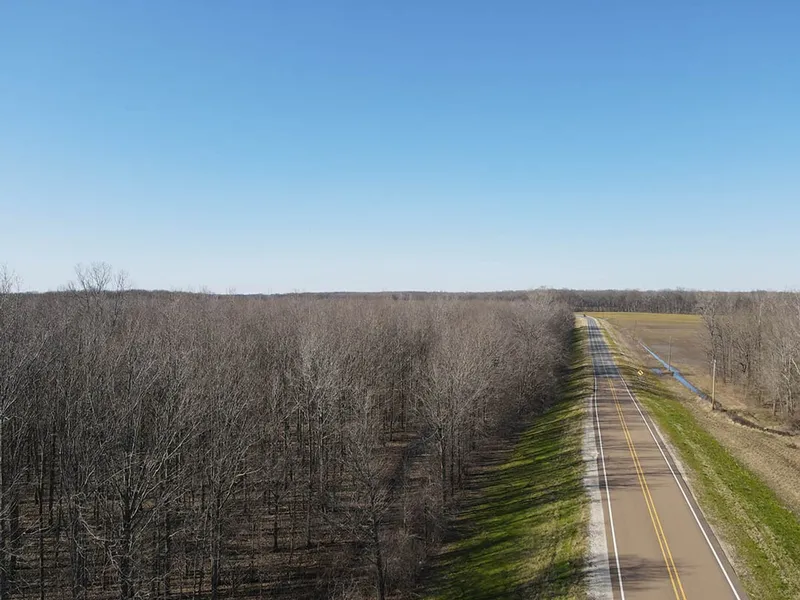
Sharkey 52.87
Welcome to the Sharkey 52.87, located just four miles southeast of Rolling Fork. This Sharkey County farm features 52.87 acres of Mississippi Delta bottomland just waiting on your recreational development. According to historical imagery, the western 20 acres appear to have been cutover approximately six to ten years ago, providing the perfect thicket for deer bedding. This area would be great for a new two to three acre wildlife plot or a few nice shooting lanes. The remainder of the property consists of expired CRP (Conservation Reserve Program) timberland. The current owner started some hedge cutting but there is plenty of room for additional development measures to provide more habitat. A perimeter road is in place for traversing the property without blowing out the entire farm. This general area is known for producing trophy whitetail, hogs, small game, and the occasional turkey. If you're a public land hunter, the Sharkey 52.87 sits less than a mile northwest of the Little Sunflower River, less than a mile northwest of the Delta National Forest, and less than ten miles northeast of the Theodore Roosevelt National Wildlife Refuge. The farm enjoys 1,250+ frontage feet along the west side of Highway 16. If you are looking for a place to build a camp or home, public water is through the City of Rolling Fork and Twin County EPA is the power provider which is available along the road frontage. Most of the Mississippi Delta is located within the FEMA Flood Zone and this tract is no different. A cabin would need to be elevated out of the flood zone. The location is convenient, being just 35 miles northeast of Vicksburg, 48 miles northwest of Madison, and 170 miles northeast of Baton Rouge, LA. If you have been searching for that hard to find and affordable Mississippi Delta tract, give Michael Oswalt a call today for your private tour of the Sharkey 52.87!
Location:
Hwy 16 Rolling Fork, MS 39159
Sharkey County
1 Miles NW of the Delta National Forest
1 Miles NW of the Little Sunflower River
4 Miles SE of Rolling Fork
35 Miles NE of Vicksburg
48 Miles NW of Madison
170 Miles NE of Baton Rouge
Coordinates:
32.8697, -90.81801
Property Use:
Recreational
Hunting
Cabin/Home Site
Property Information:
52.87 Acres
Natural Regeneration Timberland
1,250' Frontage on Hwy 16
Perimeter Road in Place
Retired CRP
Water & Power Available
Tax Information:
2023 Taxes: $229.26
Parcel #1: 085-021-014.00
Parcel #2: 085-021-013.00
From elevation to risk assessment
Search for detailed parcel information including; Elevation & Vegetation Maps, Ownership Information, Detailed Parcel Information, Crop History Map, Soil Survey Productivity Data, and more.
Research Parcel InformationResources
Land for Sale by Michael Oswalt
Sharkey County Properties By Type
- Hunting Land for Sale in Sharkey County, Mississippi
- Farms for Sale in Sharkey County, Mississippi
- Residential Property for Sale in Sharkey County, Mississippi
- Recreational Property for Sale in Sharkey County, Mississippi
- Undeveloped Land for Sale in Sharkey County, Mississippi
- Riverfront Property for Sale in Sharkey County, Mississippi
- Lakefront Property for Sale in Sharkey County, Mississippi
- Commercial Property for Sale in Sharkey County, Mississippi
- Timberland for Sale in Sharkey County, Mississippi
- Ranches for Sale in Sharkey County, Mississippi
- Horse Property for Sale in Sharkey County, Mississippi
- Beachfront Property for Sale in Sharkey County, Mississippi
Properties for Sale Nearby Counties
Sharkey County Properties By City
- Anguilla, Mississippi Land for Sale
- Cary, Mississippi Land for Sale
- Delta City, Mississippi Land for Sale
- Panther Burn, Mississippi Land for Sale
- Rolling Fork, Mississippi Land for Sale
- Fitler, Mississippi Land for Sale
- Nitta Yuma, Mississippi Land for Sale
- Onward, Mississippi Land for Sale
- Auter, Mississippi Land for Sale
- Big Eddy Landing, Mississippi Land for Sale
- Blanton, Mississippi Land for Sale
- Bommers, Mississippi Land for Sale
- More
- Cameta, Mississippi Land for Sale
- Chapel Landing, Mississippi Land for Sale
- Choctaw Landing, Mississippi Land for Sale
- Dogwood Landing, Mississippi Land for Sale
- Egremont, Mississippi Land for Sale
- Hickman Landing, Mississippi Land for Sale
- Holland Landing, Mississippi Land for Sale
- Issaquena, Mississippi Land for Sale
- Kelso, Mississippi Land for Sale
- Little Sunflower, Mississippi Land for Sale
- Lorenzen, Mississippi Land for Sale
- Mont Helena, Mississippi Land for Sale
- Patmos, Mississippi Land for Sale
- Ratliff Landing, Mississippi Land for Sale
- Richey, Mississippi Land for Sale
- Riverside Junction, Mississippi Land for Sale
- Sago, Mississippi Land for Sale
- Shraderville, Mississippi Land for Sale
- Smedes, Mississippi Land for Sale
- Spanish Fort, Mississippi Land for Sale
- Tisdell Landing, Mississippi Land for Sale
- Updike, Mississippi Land for Sale
- Vickland, Mississippi Land for Sale
- White House Landing, Mississippi Land for Sale