54217 State Highway M, New London, MO 63459 - Ralls County
9.22+/- Acres Ralls County, MO
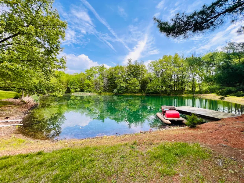
High Point Land Company is honored to present this beautiful country home located only 9 miles south of Hannibal, MO. Located in Ralls County, approximately 2 miles west of Highway 61 off of Highway M, youll find this 9.22+/- acre slice of heaven that many rural homeowners dream of. As you pull down the gravel driveway lined by cedar trees, you will see a beautiful Veneer brick home overlooking a breathtaking 1 acre stocked pond, and approximately 6 acres of solid mature timber. With a 4 car driveway, and an attached 693sq ft 2 car garage, the places to park are endless!
As you walk under the covered front porch, and open the doors to a very spacious family room, youll see the countless amenities this beautiful home has to offer. Boasting 3 fireplaces, 3 beds / 2 baths, a large kitchen, a wood stove, and a finished 990sq ft basement bringing the total living area to 3,136sq ft! Not only is the basement 100% finished, it is also accompanied by 2 storage rooms, bar countertop, bathroom, and a sliding glass door leading onto a large concrete patio with a breathtaking view of the 1 acre pond. Step out of the master bedroom onto the 12x14ft deck, or the dining room where youll find a 12x16ft deck over looking the back yard.
This property features an outbuilding, a spacious 24x31 shed with a concrete floor, and large workbench! A variety of wildlife can be found on the property, with several well used game trails leading through the timber! Those looking for a quaint rural home with acreage, look no further!
Property Address:
54217 Highway M, New London, MO 63459
Property Features:
-Beautiful rural home with acreage
-Approximately 6 miles of mature timber
-9.22+/- acres
-24x31 shed
-Finished basement
-3 bed/2 bath
-Game trails throughout the property
From elevation to risk assessment
Search for detailed parcel information including; Elevation & Vegetation Maps, Ownership Information, Detailed Parcel Information, Crop History Map, Soil Survey Productivity Data, and more.
Research Parcel InformationDirections
Turn off Highway 61 onto Highway M, property is approximately 2 miles west on the south side of Highway M.
Resources
Land for Sale by Jacob Hart
Ralls County Properties By Type
- Farms for Sale in Ralls County, Missouri
- Hunting Land for Sale in Ralls County, Missouri
- Residential Property for Sale in Ralls County, Missouri
- Lakefront Property for Sale in Ralls County, Missouri
- Timberland for Sale in Ralls County, Missouri
- Undeveloped Land for Sale in Ralls County, Missouri
- Ranches for Sale in Ralls County, Missouri
- Recreational Property for Sale in Ralls County, Missouri
- Commercial Property for Sale in Ralls County, Missouri
- Riverfront Property for Sale in Ralls County, Missouri
- Horse Property for Sale in Ralls County, Missouri
- Beachfront Property for Sale in Ralls County, Missouri
Properties for Sale Nearby Counties
Ralls County Properties By City
- Center, Missouri Land for Sale
- New London, Missouri Land for Sale
- Perry, Missouri Land for Sale
- Saverton, Missouri Land for Sale
- Hassard, Missouri Land for Sale
- Ilasco, Missouri Land for Sale
- Madisonville, Missouri Land for Sale
- Rensselaer, Missouri Land for Sale
- Salt River, Missouri Land for Sale
- Spalding, Missouri Land for Sale
- Cincinnati, Missouri Land for Sale
- Greenlawn, Missouri Land for Sale
- More