Riverfront Property - Fly Fishermans Delight
OWNER FINANCING AVAILABLE:
$1000 down (plus the $250 doc fee)
$350/mo for 96 months
---------------------------------
Your 1+ acres of sunshine sits smack dab in the #1 place to retire in the West (according to Money magazine), Klamath County, OR. With a moderate four-season climate and 300 days of sunshine, you can spend your days hiking and mountain biking, golfing at five courses, freshwater fishing at over 100 lakes, rivers and streams, or flying high at Oregon's longest zipline.
Why should you buy land in Klamath County? The locals say that the beauty of nearby Crater Lake alone is worth it. An 183,224-acre park containing America's deepest lake, striking geologic features & a historic lodge. Visitors to Crater Lake enjoy biking, fishing, swimming, boating, climbing, cross-country skiing, snowshoeing, ziplining and more. There are numerous trails around the lake for hiking and accessing the swimming beach. And if youre into birdwatching, this is a mecca its along the largest migratory bird route in the West!
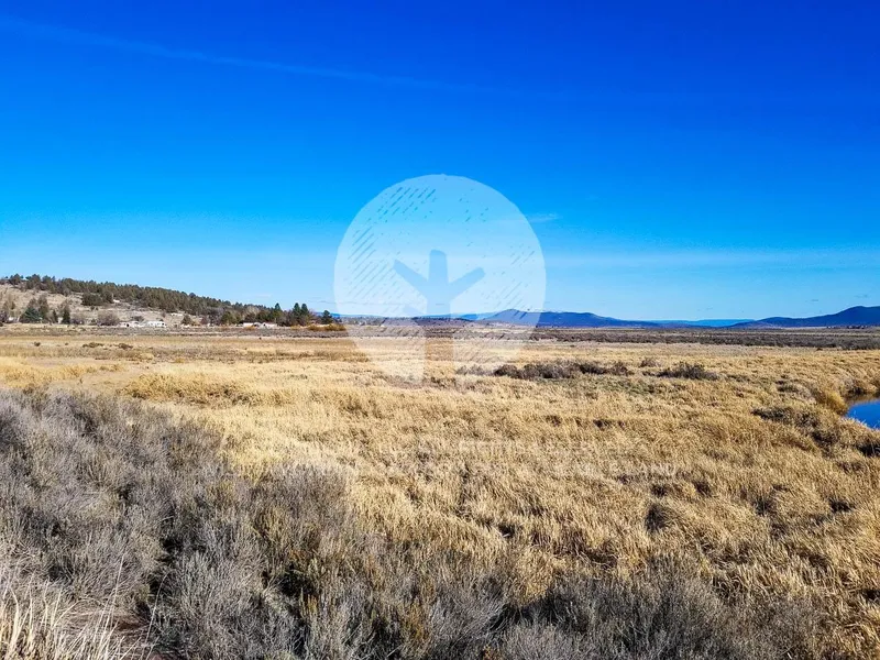
With picture-perfect mountain views as the backdrop, your property has just one neighbor and the rustic terrain is filled with bitter brush, pine, juniper trees and sage brush. Rural residential zoning and no time limit to build. Build a tiny house or camp for up to 21 days every six months. Less than a mile off the paved main road allows easy hookup to utilities. And yes, cell service is available! Ready to come call this home? Well, as they say in these parts, Meet me in Klamath!
SUBDIVISION: NIMROD RIVER PARK 2ND ADDITION
STREET ADDRESS: N/A, Coos St, Sprague River, OR 97639
STATE: OR
COUNTY: Klamath County, OR
ZIP: 97639
SIZE: 1.35 acres
LOT DIMENSIONS: 347 feet (Eastern Leg) x 320 feet (Southern Leg) x 393 feet (Western Leg) x 34 feet (Northern Leg)
APN: 350284
LEGAL DESCRIPTION:
LAT/LONG COORDINATES:
NW: 42.466716, -121.391516
NE: 42.466262, -121.390391
SW: 42.465626, -121.391182
SE: 42.466658, -121.391615
Additional Coordinates:
North: 42.466716, -121.391516
East: 42.466262, -121.390391
South: 42.465626, -121.391182
West: 42.466658, -121.391615
ELEVATION: 4,329 ft
ANNUAL TAXES: Approx. $180 per year
ZONING: Land Use Zoning: CO -(R-2) Rural Residential - No time limit to build. Site built, mobile homes & manufactured homes are okay. The building code that Klamath County uses allows houses as small as 300 sq. ft. RVs are allowed for camping but not as a permanent residence. Camping is allowed for up to 21 days every 6 month period. Permits only required if staying for more than one week at a time. Tiny homes on trailer frames are registered by DMV as an RV so fall under the camping regulations. Contact Klamath County, OR Planning and Zoning Department at Phone: 541-883-5121 Option 4, for more info.
HOA/POA: No
IMPROVEMENTS:
ACCESS: Dirt Roads
WATER: Would be a well, water haul and holding tank or other similar option
SEWER: Would be by Septic
UTILITIES: Power by solar, wind or generator, Phone by cellular, satellite TV/Internet/Phone
From elevation to risk assessment
Search for detailed parcel information including; Elevation & Vegetation Maps, Ownership Information, Detailed Parcel Information, Crop History Map, Soil Survey Productivity Data, and more.
Research Parcel InformationDirections
ACCESS: Dirt Roads
Land for Sale by Landopia
Klamath County Properties By Type
- Riverfront Property for Sale in Klamath County, Oregon
- Undeveloped Land for Sale in Klamath County, Oregon
- Farms for Sale in Klamath County, Oregon
- Lakefront Property for Sale in Klamath County, Oregon
- Beachfront Property for Sale in Klamath County, Oregon
- Residential Property for Sale in Klamath County, Oregon
- Ranches for Sale in Klamath County, Oregon
- Timberland for Sale in Klamath County, Oregon
- Recreational Property for Sale in Klamath County, Oregon
- Horse Property for Sale in Klamath County, Oregon
- Commercial Property for Sale in Klamath County, Oregon
- Hunting Land for Sale in Klamath County, Oregon
Properties for Sale Nearby Counties
Klamath County Properties By City
- Beatty, Oregon Land for Sale
- Bly, Oregon Land for Sale
- Bonanza, Oregon Land for Sale
- Chemult, Oregon Land for Sale
- Chiloquin, Oregon Land for Sale
- Crescent, Oregon Land for Sale
- Dairy, Oregon Land for Sale
- Fort Klamath, Oregon Land for Sale
- Gilchrist, Oregon Land for Sale
- Keno, Oregon Land for Sale
- Klamath Falls, Oregon Land for Sale
- Malin, Oregon Land for Sale
- More
- Merrill, Oregon Land for Sale
- Midland, Oregon Land for Sale
- Sprague River, Oregon Land for Sale
- Diamond Lake, Oregon Land for Sale
- Worden, Oregon Land for Sale
- Ainsworth Corner, Oregon Land for Sale
- Algoma, Oregon Land for Sale
- Altamont, Oregon Land for Sale
- Fairhaven, Oregon Land for Sale
- Falcon Heights, Oregon Land for Sale
- Hager, Oregon Land for Sale
- Haynesville, Oregon Land for Sale
- Henley, Oregon Land for Sale
- Hildebrand, Oregon Land for Sale
- Hot Springs, Oregon Land for Sale
- Kirk, Oregon Land for Sale
- Klamath Agency, Oregon Land for Sale
- Lake of the Woods, Oregon Land for Sale
- Langell Valley, Oregon Land for Sale
- Lorella, Oregon Land for Sale
- Malone, Oregon Land for Sale
- Modoc Point, Oregon Land for Sale
- Odell Lake, Oregon Land for Sale
- Olene, Oregon Land for Sale
- Pelican City, Oregon Land for Sale
- Rocky Point, Oregon Land for Sale
- Shady Pine, Oregon Land for Sale
- Stewart Lenox, Oregon Land for Sale
- Terminal City, Oregon Land for Sale
- Yonna, Oregon Land for Sale