Fly on over to Klamath County!
OWNER FINANCING AVAILABLE:
$500 down (plus $250 doc fee),
$225/mo. for 84 months
---------------------------------
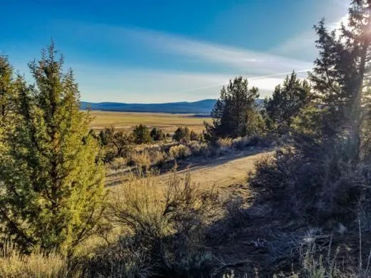
Located just north of California, Sprague River, Oregon is located in the eastern foothills of the Cascade Mountains. The area was first inhabited by Native Americans and has plenty of history in addition to plenty of places to enjoy with friends and family. Fishermen will rejoice, because this 1.59 acre lot is in the Nimrod River Park subdivision, close to the trout-filled Sprague River.
If you're not convinced yet, just ask the locals. Theyll tell you that the beauty of Crater Lake alone is worth moving here. The Park itself contains America's deepest lake, where visitors can enjoy biking, fishing, swimming, boating, climbing, cross-country skiing, snowshoeing, ziplining and more. Hike many trails around the lake and take a swim in the lake.
Theres no time limit to build and camping is allowed for up to 21 days every 6 months. Roll up in your RV or truck and spend your weekends here, or call it home by building a mobile, site-built, or manufactured home. Ready to make the move to Klamath County? Give us a call today to secure this property.
SUBDIVISION: NIMROD RIVER PARK 5TH ADDITION
STREET ADDRESS: N/A, Harney, Sprague River, OR 97639
STATE: OR
COUNTY: Klamath County, OR
ZIP: 97639
SIZE: 1.59 acres
LOT DIMENSIONS: 357 feet (Eastern Leg) x 270 feet (Western Leg) x 227 feet (Southern Leg) x 317 feet (Northern Leg)
APN: 339921
LEGAL DESCRIPTION: BLOCK 70, LOT 61, OF THE 5th ADDITION TO NIMROD RIVER PARK as shown on map in official records of said county.
LAT/LONG COORDINATES:
NW: 42.474205, -121.386778
NE: 42.473284, -121.386346
SW: 42.473008, -121.387083
SE: 42.473642, -121.387588
Additional Coordinates:
North: 42.474205, -121.386778
East: 42.473284, -121.386346
South: 42.473008, -121.387083
West: 42.473642, -121.387588
ELEVATION: 4,464 ft
ANNUAL TAXES: Approx. $180 per year
ZONING: Land Use Zoning: CO -(R-2) Rural Residential - No time limit to build. Site built, mobile homes & manufactured homes are okay. The building code that Klamath County uses allows houses as small as 300 sq. ft. RVs are allowed for camping but not as a permanent residence. Camping is allowed for up to 21 days every 6 month period. Permits only required if staying for more than one week at a time. Tiny homes on trailer frames are registered by DMV as an RV so fall under the camping regulations. Contact Klamath County, OR Planning and Zoning Department at Phone: 541-883-5121 Option 4, for more info.
HOA/POA: No
IMPROVEMENTS: None
ACCESS: Property can be accessed via Harney.
WATER: Would be a well, water haul and holding tank or other similar option
SEWER: Would be by Septic
UTILITIES: The nearest power post is about 0.7 miles away from the lot. Power could also be by solar, wind or generator, Phone by cellular, satellite TV/Internet/Phone
From elevation to risk assessment
Search for detailed parcel information including; Elevation & Vegetation Maps, Ownership Information, Detailed Parcel Information, Crop History Map, Soil Survey Productivity Data, and more.
Research Parcel InformationDirections
ACCESS: Property can be accessed via Harney.
Environmental Factors
Resources
Klamath County Properties By Type
- Undeveloped Land for Sale in Klamath County, Oregon
- Lakefront Property for Sale in Klamath County, Oregon
- Riverfront Property for Sale in Klamath County, Oregon
- Farms for Sale in Klamath County, Oregon
- Beachfront Property for Sale in Klamath County, Oregon
- Residential Property for Sale in Klamath County, Oregon
- Ranches for Sale in Klamath County, Oregon
- Recreational Property for Sale in Klamath County, Oregon
- Commercial Property for Sale in Klamath County, Oregon
- Timberland for Sale in Klamath County, Oregon
- Hunting Land for Sale in Klamath County, Oregon
- Horse Property for Sale in Klamath County, Oregon
Properties for Sale Nearby Counties
Klamath County Properties By City
- Beatty, Oregon Land for Sale
- Bly, Oregon Land for Sale
- Bonanza, Oregon Land for Sale
- Chemult, Oregon Land for Sale
- Chiloquin, Oregon Land for Sale
- Crescent, Oregon Land for Sale
- Dairy, Oregon Land for Sale
- Fort Klamath, Oregon Land for Sale
- Gilchrist, Oregon Land for Sale
- Keno, Oregon Land for Sale
- Klamath Falls, Oregon Land for Sale
- Malin, Oregon Land for Sale
- More
- Merrill, Oregon Land for Sale
- Midland, Oregon Land for Sale
- Sprague River, Oregon Land for Sale
- Diamond Lake, Oregon Land for Sale
- Worden, Oregon Land for Sale
- Ainsworth Corner, Oregon Land for Sale
- Algoma, Oregon Land for Sale
- Altamont, Oregon Land for Sale
- Fairhaven, Oregon Land for Sale
- Falcon Heights, Oregon Land for Sale
- Hager, Oregon Land for Sale
- Haynesville, Oregon Land for Sale
- Henley, Oregon Land for Sale
- Hildebrand, Oregon Land for Sale
- Hot Springs, Oregon Land for Sale
- Kirk, Oregon Land for Sale
- Klamath Agency, Oregon Land for Sale
- Lake of the Woods, Oregon Land for Sale
- Langell Valley, Oregon Land for Sale
- Lorella, Oregon Land for Sale
- Malone, Oregon Land for Sale
- Modoc Point, Oregon Land for Sale
- Odell Lake, Oregon Land for Sale
- Olene, Oregon Land for Sale
- Pelican City, Oregon Land for Sale
- Rocky Point, Oregon Land for Sale
- Shady Pine, Oregon Land for Sale
- Stewart Lenox, Oregon Land for Sale
- Terminal City, Oregon Land for Sale
- Yonna, Oregon Land for Sale