Keno Oregon Heavily Wooded Building Lot - Over One Acre - Power
Description
***See all of our listings by visiting us at governmentlandsales.us***
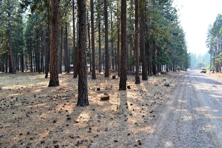
Wonderful timbered and level lot with power, located just outside of Keno, Oregon. Measuring in at over an acre, this lot has the feel of full-time camping, tucked in a secluded and quiet residential neighborhood. Build your home or bring your mobile and stretch out as there is plenty of room to do so.
Keno
Keno is a great little town. Its got that off-the-beaten track, locals-only, undiscovered territory kind of charm. It is an unincorporated community in Klamath County, Oregon, southwest of Klamath Falls on the Klamath River near Oregon Route 66. The town population hovers around 1200 residents. Keno's elevation is 4,108 feet above sea level. It is a town of history and adventure and is home to the Bill Scholtes Klamath Sportsmans Park. This multiuse facility has a motocross course, four wheel drive and off-highway course, an airfield for radio controlled aircraft, shooting ranges for both rifle and archery, picnic and camping areas, access to fishing on the Klamath River and more.
Klamath Falls
Located just 12 miles northeast, Klamath Falls is the county seat for Klamath County, Oregon, and the majority of the county population resides here. Home to national chains and local flare, the city has all services one would need. It is also home to the largest freshwater lake by surface area in the state of Oregon, Upper Klamath Lake. Measuring 25 miles long and 8 miles wide, the lake is a sportsman's paradise. Also overlooking the lake, the nearby Running Y Ranch Resort & hotel features a golf course designed by Arnold Palmer and an ice skating arena.
Klamath Falls has developed a series of trails in Moore Park. The trail network in and around Moore Park is well loved and heavily used by hikers, cyclists, runners, and others. Crater Lake National Park is less than 50 miles north of Klamath Falls, and the 33-mile Rim Drive, which circles the lake, is a favorite of cyclists. Winter cross country skiing and snow shoeing in the park is also very popular.
Land Information:
Legal: Klamath River Acres 4th Addition Block 25 Lot 2
APN: 488911
Map and Taxlot: 3907-026D0-08300-000
Size: 1.16 Acres
Dimensions: 289' X 223' X 280' X 152'
GPS: Approximate GPS Coordinates
42.1411, -121.9592 (NW Corner)
42.1412, -121.9581 (NE Corner)
42.1406, -121.9581 (SE Corner)
42.1406, -121.9591 (SW Corner)
Owner financing available, please inquire. No credit checks, everyone qualifies. We accept all major credit cards. All cash offers are considered.
Document Preparation Fee: $299
Property ID: C-2021062-BEFTT
From elevation to risk assessment
Search for detailed parcel information including; Elevation & Vegetation Maps, Ownership Information, Detailed Parcel Information, Crop History Map, Soil Survey Productivity Data, and more.
Research Parcel InformationEnvironmental Factors
Klamath County Properties By Type
- Undeveloped Land for Sale in Klamath County, Oregon
- Farms for Sale in Klamath County, Oregon
- Residential Property for Sale in Klamath County, Oregon
- Riverfront Property for Sale in Klamath County, Oregon
- Beachfront Property for Sale in Klamath County, Oregon
- Lakefront Property for Sale in Klamath County, Oregon
- Ranches for Sale in Klamath County, Oregon
- Hunting Land for Sale in Klamath County, Oregon
- Recreational Property for Sale in Klamath County, Oregon
- Commercial Property for Sale in Klamath County, Oregon
- Timberland for Sale in Klamath County, Oregon
- Horse Property for Sale in Klamath County, Oregon
Properties for Sale Nearby Counties
Klamath County Properties By City
- Beatty, Oregon Land for Sale
- Bly, Oregon Land for Sale
- Bonanza, Oregon Land for Sale
- Chemult, Oregon Land for Sale
- Chiloquin, Oregon Land for Sale
- Crescent, Oregon Land for Sale
- Dairy, Oregon Land for Sale
- Fort Klamath, Oregon Land for Sale
- Gilchrist, Oregon Land for Sale
- Keno, Oregon Land for Sale
- Klamath Falls, Oregon Land for Sale
- Malin, Oregon Land for Sale
- More
- Merrill, Oregon Land for Sale
- Midland, Oregon Land for Sale
- Sprague River, Oregon Land for Sale
- Diamond Lake, Oregon Land for Sale
- Worden, Oregon Land for Sale
- Ainsworth Corner, Oregon Land for Sale
- Algoma, Oregon Land for Sale
- Altamont, Oregon Land for Sale
- Fairhaven, Oregon Land for Sale
- Falcon Heights, Oregon Land for Sale
- Hager, Oregon Land for Sale
- Haynesville, Oregon Land for Sale
- Henley, Oregon Land for Sale
- Hildebrand, Oregon Land for Sale
- Hot Springs, Oregon Land for Sale
- Kirk, Oregon Land for Sale
- Klamath Agency, Oregon Land for Sale
- Lake of the Woods, Oregon Land for Sale
- Langell Valley, Oregon Land for Sale
- Lorella, Oregon Land for Sale
- Malone, Oregon Land for Sale
- Modoc Point, Oregon Land for Sale
- Odell Lake, Oregon Land for Sale
- Olene, Oregon Land for Sale
- Pelican City, Oregon Land for Sale
- Rocky Point, Oregon Land for Sale
- Shady Pine, Oregon Land for Sale
- Stewart Lenox, Oregon Land for Sale
- Terminal City, Oregon Land for Sale
- Yonna, Oregon Land for Sale