1.49 Acres near Crater Lake, Zoned for Your Big Dreams
OWNER FINANCING AVAILABLE:
$250 down (plus $250 doc fee),
$225/mo. for 86---- months
-----------------------------
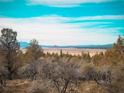
Dreaming of an adventure thats all your own? Set your sights on Sprague River, OR, where 1.49 acres of raw land await in the Nimrod River Park subdivision. Heres your chance to transform a blank slate into the sanctuary you've always wanted. Just 3,600 feet south, the Sprague River meanders gracefully, inviting you to explore its majestic beauty every day. Whats even better? We also have the adjoining 1.53-acre lot available, allowing you to expand your horizons effortlessly.
The land itself boasts gentle slopes and lush vegetation, offering you a truly picturesque setting. Visualize your dream home overlooking the serene Sprague River, surrounded by the natural beauty this area is known for. Near the majestic Cascade Mountains, this plot offers panoramic views that will make every morning a splendid experience. This property is truly a blank canvas waiting for your personal touch.
Dont miss your chance to claim this unique piece of Sprague River paradise! Such prime parcels dont come around oftenand they dont stay on the market for long. Take action now to secure your own slice of Oregons pristine wilderness. Contact us today to start your journey towards owning this extraordinary property. Check out our testimonials and take advantage of our 100% money-back guarantee. Your dream land is just a decision away!
SUBDIVISION: NIMROD RIVER PARK 4TH ADDITION
STREET ADDRESS: N/A, Rim Drive, Sprague River, OR 97639
STATE: OR
COUNTY: Klamath County, OR
ZIP: 97639
SIZE: 1.49 acres
LOT DIMENSIONS: 399 feet x 175 feet
APN: 327202 & 327211
LEGAL DESCRIPTION: Block 32, Lot 35, OF THE 4th ADDITION TO NIMROD RIVER PARK as shown on map in official records of said county.
LAT/LONG COORDINATES:
NW: 42.473482, -121.491412
NE: 42.473676, -121.490815
SW: 42.472575, -121.490575
SE: 42.472839, -121.490047
ELEVATION: 4,596 ft
ANNUAL TAXES: Approx. $90 per year
ZONING: (R-2) Rural Residential - No time limit to build. Site built, mobile homes & manufactured homes are okay. The building code that Klamath County uses allows houses as small as 300 sq. ft. RVs are allowed for camping but not as a permanent residence. Camping is allowed for up to 21 days every 6 month period. Permits only required if staying for more than one week at a time. Tiny homes on trailer frames are registered by DMV as an RV so fall under the camping regulations. Contact Klamath County, OR Planning and Zoning Department at Phone: 541-883-5121 Option 4, for more info.
HOA/POA: No
IMPROVEMENTS: None
ACCESS: Dirt Roads
WATER: Would be a well, water haul and holding tank or other similar option
SEWER: Would be by Septic
UTILITIES: Nearest power post is about .1 mile away from the property. Power could also be by solar, wind or generator, Phone by cellular, satellite TV/Internet/Phone
From elevation to risk assessment
Search for detailed parcel information including; Elevation & Vegetation Maps, Ownership Information, Detailed Parcel Information, Crop History Map, Soil Survey Productivity Data, and more.
Research Parcel InformationDirections
ACCESS: Dirt Roads
Resources
Land for Sale by Landopia
Klamath County Properties By Type
- Undeveloped Land for Sale in Klamath County, Oregon
- Farms for Sale in Klamath County, Oregon
- Riverfront Property for Sale in Klamath County, Oregon
- Lakefront Property for Sale in Klamath County, Oregon
- Ranches for Sale in Klamath County, Oregon
- Residential Property for Sale in Klamath County, Oregon
- Beachfront Property for Sale in Klamath County, Oregon
- Recreational Property for Sale in Klamath County, Oregon
- Commercial Property for Sale in Klamath County, Oregon
- Timberland for Sale in Klamath County, Oregon
- Horse Property for Sale in Klamath County, Oregon
- Hunting Land for Sale in Klamath County, Oregon
Properties for Sale Nearby Counties
Klamath County Properties By City
- Beatty, Oregon Land for Sale
- Bly, Oregon Land for Sale
- Bonanza, Oregon Land for Sale
- Chemult, Oregon Land for Sale
- Chiloquin, Oregon Land for Sale
- Crescent, Oregon Land for Sale
- Dairy, Oregon Land for Sale
- Fort Klamath, Oregon Land for Sale
- Gilchrist, Oregon Land for Sale
- Keno, Oregon Land for Sale
- Klamath Falls, Oregon Land for Sale
- Malin, Oregon Land for Sale
- More
- Merrill, Oregon Land for Sale
- Midland, Oregon Land for Sale
- Sprague River, Oregon Land for Sale
- Diamond Lake, Oregon Land for Sale
- Worden, Oregon Land for Sale
- Ainsworth Corner, Oregon Land for Sale
- Algoma, Oregon Land for Sale
- Altamont, Oregon Land for Sale
- Fairhaven, Oregon Land for Sale
- Falcon Heights, Oregon Land for Sale
- Hager, Oregon Land for Sale
- Haynesville, Oregon Land for Sale
- Henley, Oregon Land for Sale
- Hildebrand, Oregon Land for Sale
- Hot Springs, Oregon Land for Sale
- Kirk, Oregon Land for Sale
- Klamath Agency, Oregon Land for Sale
- Lake of the Woods, Oregon Land for Sale
- Langell Valley, Oregon Land for Sale
- Lorella, Oregon Land for Sale
- Malone, Oregon Land for Sale
- Modoc Point, Oregon Land for Sale
- Odell Lake, Oregon Land for Sale
- Olene, Oregon Land for Sale
- Pelican City, Oregon Land for Sale
- Rocky Point, Oregon Land for Sale
- Shady Pine, Oregon Land for Sale
- Stewart Lenox, Oregon Land for Sale
- Terminal City, Oregon Land for Sale
- Yonna, Oregon Land for Sale
