Cul De Sac Seclusion
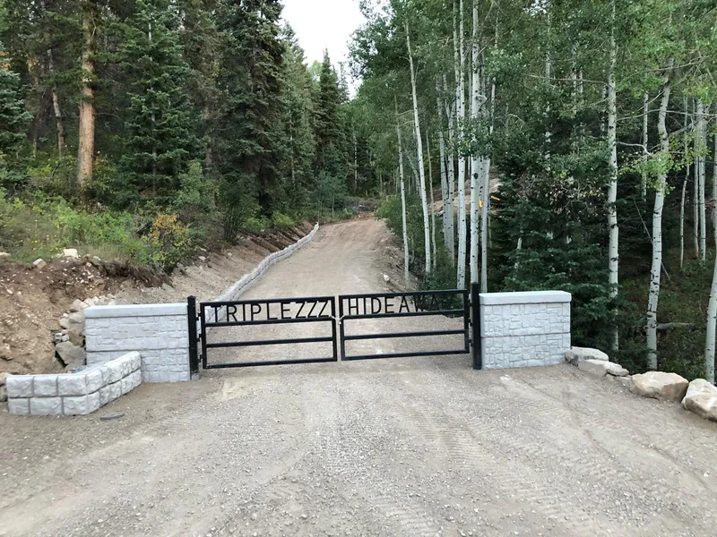
Unique setting with this improved lot. Water is connected, 3" conduit line is installed...copper power line not installed. Concrete wall runs from entry and surrounding back wall of pad. Gate installed for instant private access. 13.56 acres has two Spring creeks water running during snow melt. Thick Pines and Quaking Aspens. Front and both sides sloped...back of lot has sectional flat. (NOTE: Back of lot has an old cut-through road for developer. This is no longer in use and gated.)
From elevation to risk assessment
Search for detailed parcel information including; Elevation & Vegetation Maps, Ownership Information, Detailed Parcel Information, Crop History Map, Soil Survey Productivity Data, and more.
Research Parcel InformationDirections
From I-15 - Highway 6 off ramp intersection. Head East 37 miles up Highway 6. As you reach your roughly 37 miles on your right is a 10 wide 12 high Soldier Summit sign nestled between large tree logs. Turn right onto dirt road or Soldier Summit Dr. Road will make couple short curves then you will continue South over Rail Road tracks. Close gate as you enter...thanks! Continue on Soldier Summit dr to T in road...turning right onto Alta Dr then turn left onto Snowbird drive. Heading south up the Snowbird Dr make your second right onto Brighton Circle. Follow Brighton Circle to Culdesac where C50 Seclusion begins. Grab your Plat C map to help you navigate.
Resources
Land for Sale by Steve Fritzsche
Utah County Properties By Type
- Undeveloped Land for Sale in Utah County, Utah
- Farms for Sale in Utah County, Utah
- Commercial Property for Sale in Utah County, Utah
- Ranches for Sale in Utah County, Utah
- Residential Property for Sale in Utah County, Utah
- Horse Property for Sale in Utah County, Utah
- Lakefront Property for Sale in Utah County, Utah
- Recreational Property for Sale in Utah County, Utah
- Riverfront Property for Sale in Utah County, Utah
- Timberland for Sale in Utah County, Utah
- Hunting Land for Sale in Utah County, Utah
- Beachfront Property for Sale in Utah County, Utah
Properties for Sale Nearby Counties
Utah County Properties By City
- Alpine, Utah Land for Sale
- American Fork, Utah Land for Sale
- Eagle Mountain, Utah Land for Sale
- Goshen, Utah Land for Sale
- Lehi, Utah Land for Sale
- Lindon, Utah Land for Sale
- Mapleton, Utah Land for Sale
- Orem, Utah Land for Sale
- Payson, Utah Land for Sale
- Pleasant Grove, Utah Land for Sale
- Provo, Utah Land for Sale
- Salem, Utah Land for Sale
- More
- Santaquin, Utah Land for Sale
- Saratoga Springs, Utah Land for Sale
- Spanish Fork, Utah Land for Sale
- Springville, Utah Land for Sale
- Benjamin, Utah Land for Sale
- Bunker, Utah Land for Sale
- Cedar Fort, Utah Land for Sale
- Cedar Hills, Utah Land for Sale
- Elk Ridge, Utah Land for Sale
- Fairfield, Utah Land for Sale
- Genola, Utah Land for Sale
- Highland, Utah Land for Sale
- Lake Shore, Utah Land for Sale
- Lakeview, Utah Land for Sale
- Leland, Utah Land for Sale
- Mammoth, Utah Land for Sale
- Palmyra, Utah Land for Sale
- Spring Lake, Utah Land for Sale
- Vineyard, Utah Land for Sale
- Woodland Hills, Utah Land for Sale
- Aspen Grove, Utah Land for Sale
- Canyon Glen, Utah Land for Sale
- Caryhurst, Utah Land for Sale
- Castilla, Utah Land for Sale
- Christmas City, Utah Land for Sale
- Colton, Utah Land for Sale
- Dividend, Utah Land for Sale
- Geneva, Utah Land for Sale
- Gilluly, Utah Land for Sale
- Gomex, Utah Land for Sale
- Gorder, Utah Land for Sale
- Hardy, Utah Land for Sale
- Homansville, Utah Land for Sale
- Ironton, Utah Land for Sale
- Keigley, Utah Land for Sale
- Knightville, Utah Land for Sale
- Kyune, Utah Land for Sale
- Lant, Utah Land for Sale
- Lewis, Utah Land for Sale
- Mill Fork, Utah Land for Sale
- Moark Junction, Utah Land for Sale
- Mosida, Utah Land for Sale
- Mount Nebo, Utah Land for Sale
- Mutual Dell, Utah Land for Sale
- Nunns, Utah Land for Sale
- Olmstead, Utah Land for Sale
- Orem Station, Utah Land for Sale
- Patrick Place, Utah Land for Sale
- Pines, Utah Land for Sale
- Rio, Utah Land for Sale
- Sky View, Utah Land for Sale
- Soldier Summit, Utah Land for Sale
- Springdell, Utah Land for Sale
- Sutro, Utah Land for Sale
- Three Forks, Utah Land for Sale
- Townsend, Utah Land for Sale
- Tucker, Utah Land for Sale
- Vivian Park, Utah Land for Sale
- West Mountain, Utah Land for Sale
- West Portal, Utah Land for Sale
- Wicks, Utah Land for Sale
- Wing, Utah Land for Sale
- Elberta, Utah Land for Sale