Union 61.32
Description
Welcome to the Union 61.32, located in New Albany, Mississippi. Imagine owning 61.32 acres in the heart of a proven wildlife neighborhood. This Union County property doesn’t just look good on paperit hunts big, benefiting from the expansive, well-managed surroundings that funnel deer, turkey, and waterfowl through the area.
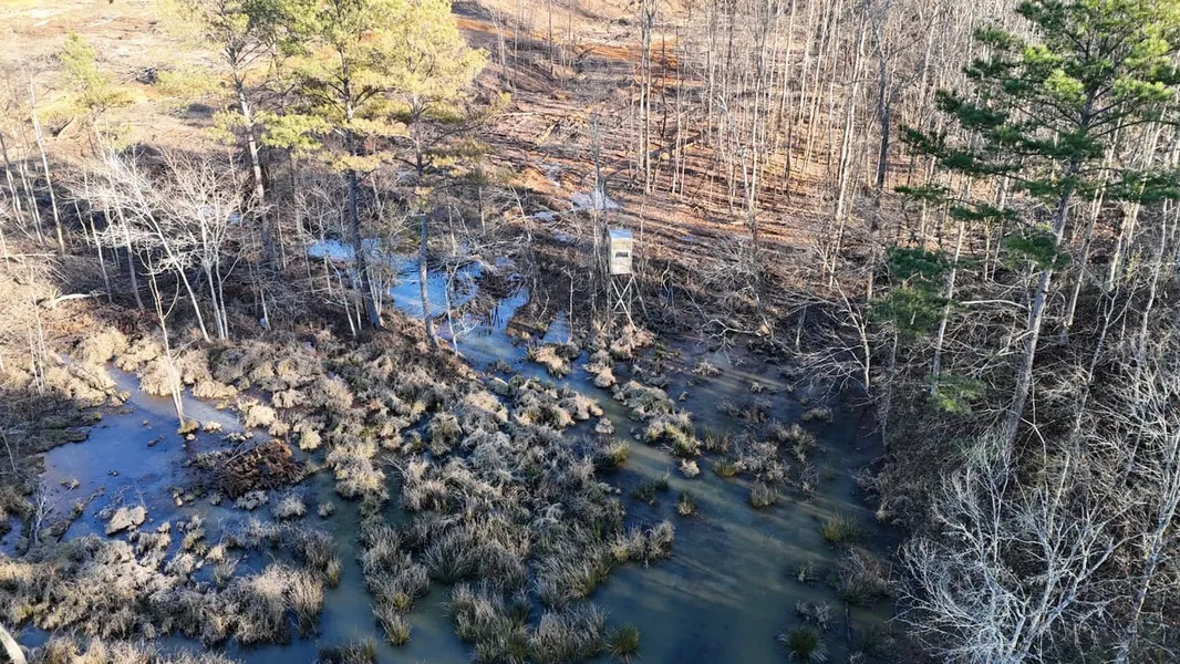
This turnkey hunting tract is loaded with features and ready to enjoy immediately. The property includes two shooting houses, multiple established food plots, and a well-planned internal trail system that allows quiet, efficient access throughout the land. One of the standout features is a duck hole, offering a rare bonus for waterfowl hunters and adding true diversity to the recreational value of the property.
Well-known for its strong deer and turkey populations, this area is ideal for chasing mature whitetails, listening to spring gobblers, or simply enjoying a peaceful retreat to the outdoors. In addition to its hunting appeal, the tract offers excellent building sites with electricity and community water available, making it well-suited for a hunting cabin or future home. If you’re searching for manageable acreage that delivers big hunting potential, the Union 61.32 is worth a visit.
Contact Annah Barnes today to schedule a private showing and experience #TheSmallTownWay!
Location:
County Road 731
New Albany, MS 38652
Union County
11.5 Miles SE of Ripley
11.7 Miles NE of New Albany
38 Miles NW of Tupelo
47 Miles NE of Oxford
103 Miles SE of Memphis, TN
Coordinates:
34.594417, -88.904123
Property Use:
Hunting
Recreational
Potential Home/Cabin Site
Investment
Property Information:
61.32 Turnkey Acres
Established Food Plots
Maintained Internal Trail System
Deer, Turkey, & Ducks
Duck Hole
Seasonal Creek
Electricity Available
Community Water On-Site
Tax Information:
Parcel: 075R-05-003.00
2024: $200
From elevation to risk assessment
Search for detailed parcel information including; Elevation & Vegetation Maps, Ownership Information, Detailed Parcel Information, Crop History Map, Soil Survey Productivity Data, and more.
Research Parcel InformationEnvironmental Factors
Resources
Union County Properties By Type
- Hunting Land for Sale in Union County, Mississippi
- Undeveloped Land for Sale in Union County, Mississippi
- Residential Property for Sale in Union County, Mississippi
- Lakefront Property for Sale in Union County, Mississippi
- Ranches for Sale in Union County, Mississippi
- Farms for Sale in Union County, Mississippi
- Riverfront Property for Sale in Union County, Mississippi
- Commercial Property for Sale in Union County, Mississippi
- Recreational Property for Sale in Union County, Mississippi
- Timberland for Sale in Union County, Mississippi
- Horse Property for Sale in Union County, Mississippi
- Beachfront Property for Sale in Union County, Mississippi
Properties for Sale Nearby Counties
Union County Properties By City
- Blue Springs, Mississippi Land for Sale
- Etta, Mississippi Land for Sale
- Myrtle, Mississippi Land for Sale
- New Albany, Mississippi Land for Sale
- Alpine, Mississippi Land for Sale
- Branyan, Mississippi Land for Sale
- Center, Mississippi Land for Sale
- Fairfield, Mississippi Land for Sale
- Ingomar, Mississippi Land for Sale
- Jericho, Mississippi Land for Sale
- Keownville, Mississippi Land for Sale
- Locum, Mississippi Land for Sale
- More
- New Harmony, Mississippi Land for Sale
- North Haven, Mississippi Land for Sale
- Pinedale, Mississippi Land for Sale
- Pleasant Ridge, Mississippi Land for Sale
- Pumpkin Center, Mississippi Land for Sale
- Wallerville, Mississippi Land for Sale
- Baker, Mississippi Land for Sale
- Bald Hill, Mississippi Land for Sale
- Beacon Hill, Mississippi Land for Sale
- Concord, Mississippi Land for Sale
- Darden, Mississippi Land for Sale
- Flatwood, Mississippi Land for Sale
- Gallway, Mississippi Land for Sale
- Glenfield, Mississippi Land for Sale
- Halltown, Mississippi Land for Sale
- Locust Grove, Mississippi Land for Sale
- Martintown, Mississippi Land for Sale
- Molino, Mississippi Land for Sale
- Old Myrtle, Mississippi Land for Sale
- Parks, Mississippi Land for Sale
- Poolville, Mississippi Land for Sale
- Reese, Mississippi Land for Sale
- Shari, Mississippi Land for Sale
- Smalco, Mississippi Land for Sale
- Union Hill, Mississippi Land for Sale